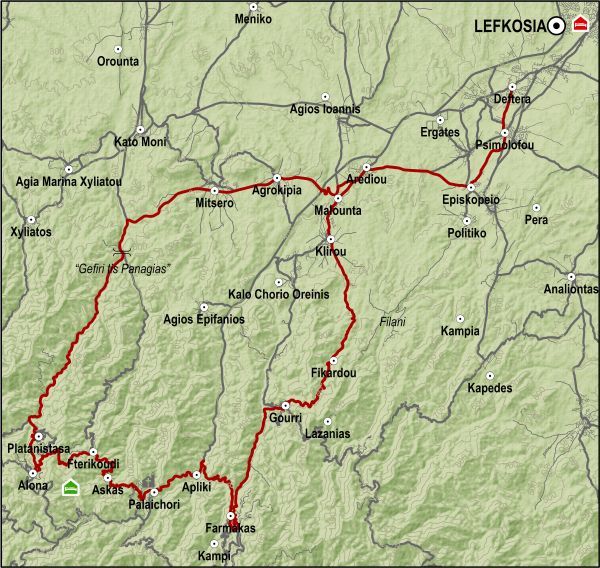
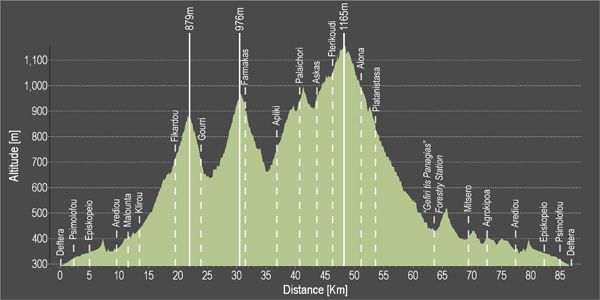
The route follows part of the course from Lefkosia (Deftera) to Machairas up to the village of Episkopeio, but from there it heads west to the village of Arediou instead of the village of Politiko. It gradually climbs from the old Lefkosia-Palaichori road going through Malounta and Klirou and turns left towards Fikardou. From Fikardou it goes downhill to Gourri and then turns right on the road towards Gourri. After you pass through Gourri at the next junction you go left towards the village of Farmakas. From Farmakas the route continues west Apliki. From there it follows the road to Palaichori. From the village of Palaichori after a short climb turns right to take the road for Askas, Fterikoudi and Alona, where it turns right heading north and begins the descent towards Lefkosia. At Alona there is accommodation and restaurants if you wish to spend the night or a few more days in the area. After leaving Alona the course descends towards Platanistasa, passes the “Gefiri tis Panagias” forestry station, arriving at a right turn that leads east to the villages of Mitsero and Agrokipia and ultimately coming out at the Lefkosia-Palaichori road. From there to the left and south, the course reaches the Klirou District Gymnasium, where it turns right just before Arediou to meet the old Lefkosia-Palaichori road heading back to Lefkosia in the opposite direction.
Alternative route: At Gourri, instead of heading towards Lazanias, take the paved road for Farmakas and Palaichori. Turn right and to the north from Palaichori, instead of heading towards Askas-Alona, and start descending to Lefkosia (Deftera).
Difficulty rate: Quite a difficult course even though that the route is descending all the way past the village of Alona. It requires a road bike with low/ easy gear ratios.
To download the route in gpx format click here
| Distance: | 87.3km |
| Elevation Gain: | 2583m |
| Highest point: | 1165m |
| Lowest point: | 290m |
| Loop: | YES |
| Terrain: | Mountain |
| Road surface: | Paved |
| Section Distance (km) | Total Distance (km) | |
| Deftera | 0,0 | 0,0 |
| Psimolofou | 2,1 | 2,1 |
| Episkopeio | 3,0 | 5,1 |
| Arediou | 4,6 | 9,7 |
| Malounta | 1,8 | 11,5 |
| Klirou | 1,9 | 13,4 |
| Fikardou | 6,0 | 19,4 |
| Gourri | 4,5 | 23,9 |
| Farmakas | 7,2 | 31,1 |
| Apliki | 5,9 | 37,0 |
| Palaichori | 3,7 | 40,7 |
| Askas | 2,9 | 43,6 |
| Fterikoudi | 2,6 | 46,2 |
| Alona | 4,8 | 51,0 |
| Platanistasa | 2,4 | 53,4 |
| "Gefiri tis Panagias" Forestry Station | 10,4 | 63,8 |
| Mitsero | 5,7 | 69,5 |
| Agrokipia | 2,8 | 72,3 |
| Arediou | 5,3 | 77,6 |
| Episkopeio | 4,6 | 82,2 |
| Psimolofou | 3,0 | 85,2 |
| Deftera | 2,1 | 87,3 |


