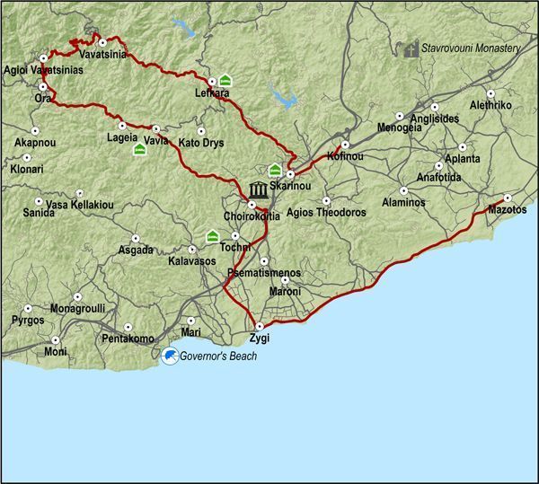
From there the road climbs to the north towards Tochni and reaches the archaeological site of Choirokitia.
The route continues in a northwestern direction, going through the village of Choirokitia and, climbing steadily, goes through the villages of Vavla, Lageia and Ora.
From Ora it turns right and after 10km, heading first north and then northwest, reaches Vavatsinia. Vavatsinia is a good spot to rest and have a snack before heading back down to Kofinou via the villages of Pano Lefkara and Skarinou. Kofinou is a 5km ride to the north of Skarinou on the old Lefkosia - Lemesos road.
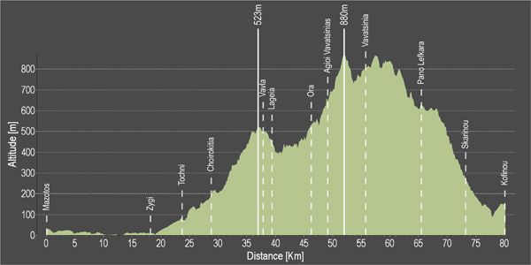
Difficulty rate: A difficult route with long but not very steep uphills. It requires a 20-speed road bicycle.
Road condition: Paved roads throughout.
Route Description: This route travels along the western coastal district of Larnaka and then climbs towards the hillside villages of the region, going past the archaeological site of Choirokoitia and ending at Kofinou.
Alternative route: From Vavla the route turns right and climbs up to the village of Kato Drys (6km), then three kilometers later gets on the Skarinou -Vavatsinia road, just below Pano Lefkara. This route is shorter.
To download the route in gpx format click here
| Distance: | 78.3km |
| Elevation Gain: | 1882m |
| Highest point: | 880m |
| Lowest point: | 1m |
| Loop: | NO |
| Terrain: | Mountain |
| Road surface: | Paved |
| Section Distance (km) | Total Distance (km) | |
| Mazotos fuel station | 0,0 | 0,0 |
| Zygi | 18,2 | 18,2 |
| Tochni | 5,6 | 23,8 |
| Choirokitia | 5,1 | 28,9 |
| Vavla | 8,4 | 37,34 |
| Lageia | 2,2 | 39,5 |
| Ora | 6,7 | 46,2 |
| Agioi Vavatsinias | 2,9 | 49,1 |
| Vavatsinia | 6,7 | 55,8 |
| Pano Lefkara | 9,6 | 65,4 |
| Skarinou | 7,8 | 73,2 |
| Kofinou | 5,1 | 78,3 |


