To read the written tour of Agios Nikolaos tis Stegis please click here.
Author: cconstantinou
Agios Lazaros Church and Ecclesiastical Museum – Audio Guide
Introducton
Customs and Traditions
Larnaca Ecclesiastical Museum
Hall 1
Hall 2
Hall 3
Hall 4
Hall 5
In detail
To read the written tour of Agios Lazaros Church, please click here.
To listen the entire tour please click here.
Agia Napa Monastery – Audio Guide
Introduction
George Seferis poem Agia Napa
Let us now take a virtual tour of the monument
Within the agia napa municipality
To read the written tour of The Agia Napa Monastery please click here.
To listen the entire tour please click here.
Catering and Entertainment Establishments

European Mediterranean Route EuroVelo 8
Discover and enjoy the natural beauty of the island from the pedal of a bike with our suggested itineraries, all created to put you on the ‘right track’ and showcase Cyprus’ stunning landscape.
Cyprus is also part of the cofunded project ‘MedCycleTour’, which is based on the ‘European Mediterranean Route – EuroVelo 8’, one of the 15 long distance cycle routes in the network ‘EuroVelo’ that connects 11 countries. ‘MedCycleTour’ aims to develop cycle tourism in the Mediterranean region by providing transnational tools to attract visitors. The project is cofunded by the Interreg Mediterranean Programme, the project has a budget of over €2,5 million.
The MedCycleRoute project will contribute to the development of the EuroVelo 8 – Mediterranean Route by exchanging good practices; surveying the existing cycle route; developing regional and transnational action plans; preparing and publishing promotional material related to EuroVelo 8; and implementing pilot projects such as signposting, promotional tools (web sites, apps, etc.) and cycle friendly schemes.
Lead by the Andalusian Government – Agency of Public Works, Andalusian Ministry of Development and Housing (Spain) -, the project has 10 other partners from 7 countries, besides the Deputy Ministry of Tourism. The European Cyclists´ Federation (Belgium), Alpes Maritimes (France), Catalonia Region (Spain), Western Greece (Greece), Friuli Venezia Giulia Region (Italy), Province of Mantova (Italy), Regional Development Center of Koper (Slovenia), Croatian National Tourism Board (Croatia) and the Cluster for Eco-Social Innovation and Development (Croatia).
For more information about EuroVelo please visit: www.eurovelo.com
For more information about EuroVelo 8 please visit: www.eurovelo8.com
For more information about MedCycleTour project please visit: https://medcycletour.interreg-med.eu/ or please contact Thalia Christodoulidou at [email protected].
Happy cycling!

Vasilikos Maroni Panorama
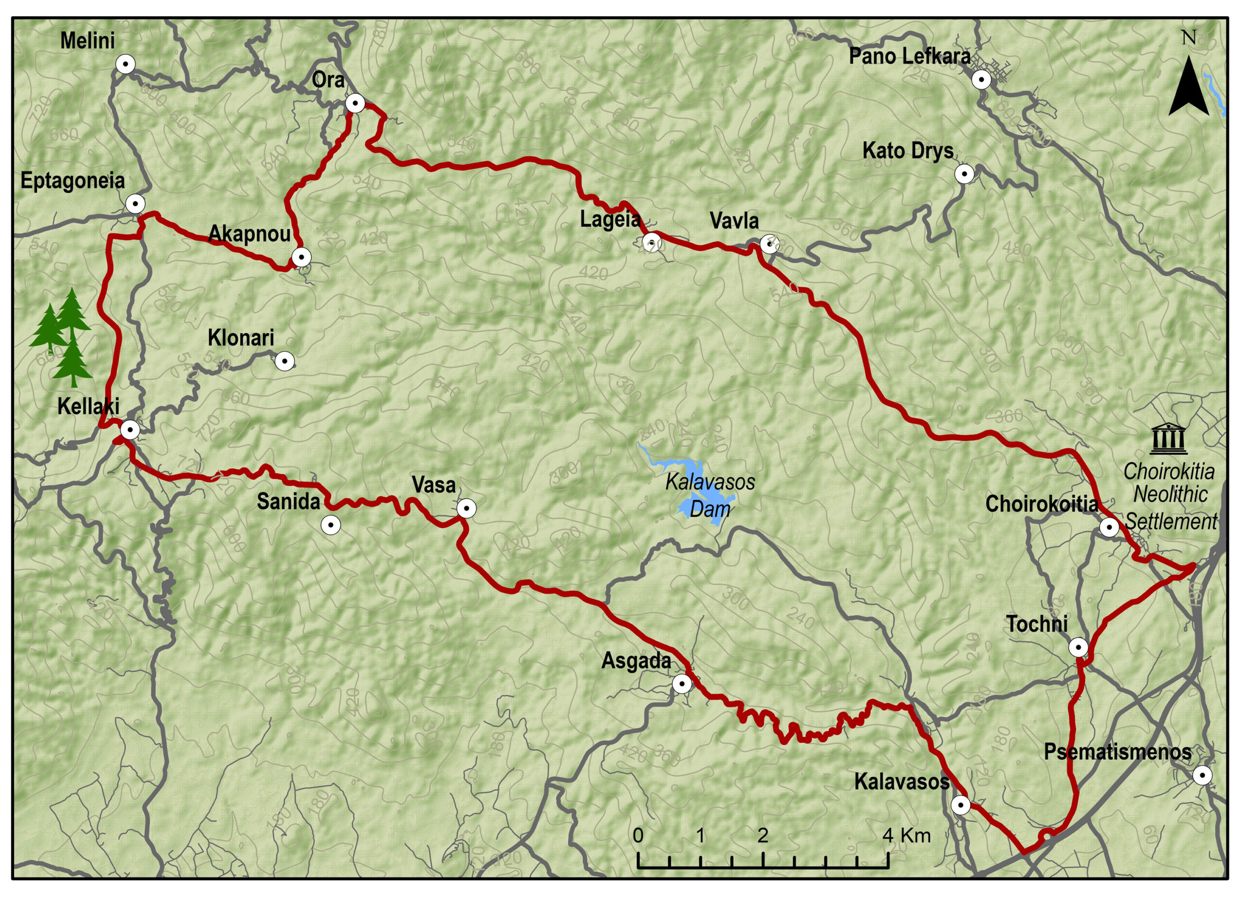
The route starts from the village of Kalavasos with a slight uphill ascent towards the village of Asgata. Pass through the narrow streets of the village and continue uphill to Vasa, Sanida and then to Kellaki. Woodland areas and unique views will be encountered along the way. Ride downhill to reach the Eptagoneia Village and the small picturesque village of Akapnou. Continue towards Ora, Lageia, Vavla and ride further downhill to Choirokoitia. Pass through the village of the picturesque and beautiful Tochni to reach the starting point in Kalavasos.
To download the route in gpx format click here
| Distance: | 57.6km |
| Elevation Gain: | 1169m |
| Highest point: | 724m |
| Lowest point: | 65m |
| Loop: | YES |
| Terrain: | Mountain |
| Road surface: | Paved |
| Section Distance (km) | Total Distance (km) | |
| Kalavasos | 0,0 | 0,0 |
| Asgada | 6.6 | 6.6 |
| Vasa | 5.1 | 11.7 |
| Sanida | 3.6 | 15.3 |
| Kellaki | 4.1 | 19.4 |
| Eptagonia | 4.5 | 23.9 |
| Akapnou | 3.0 | 26.9 |
| Ora | 3.5 | 30.4 |
| Lageia | 6.3 | 36.7 |
| Vavla | 2.4 | 39.1 |
| Choirokoitia | 9.7 | 48.8 |
| Choirokoitia Neolithic Settlement | 0.0 | 48.8 |
| Tochni | 2.8 | 51.6 |
| Kalavasos | 6.0 | 57.6 |

Vasilikos Maroni Panorama Intense
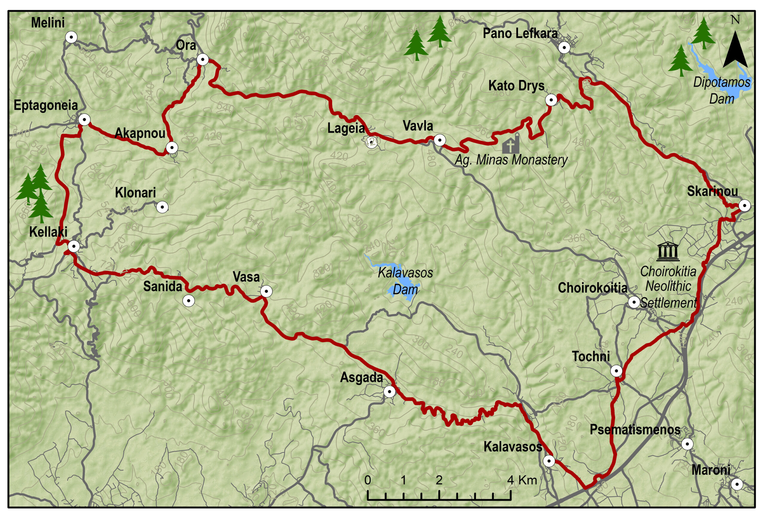
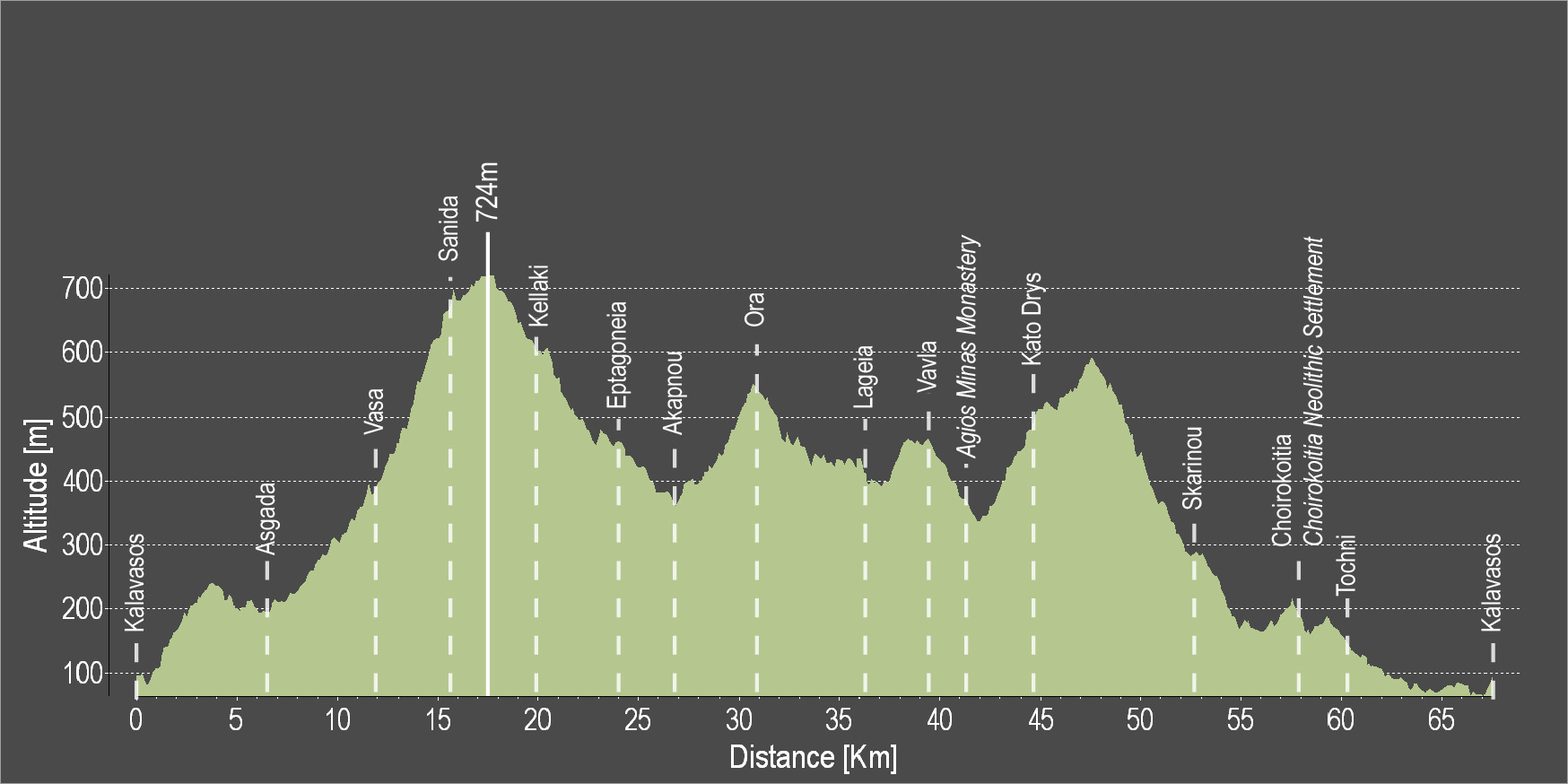
The route starts from the village of Kalavasos with a slight uphill ascent towards the village of Asgata. Pass through the narrow streets of the village and continue uphill to Vasa, Sanida and then to Kellaki. Woodland areas and unique views will be encountered along the way. Ride downhill to reach the Eptagoneia Village and the small picturesque village of Akapnou. Continue towards Ora, Lageia, Vavla and then ride uphill to Kato Drys village. A big downhill ride will follow which leads to the village of Skarinou. Pass through the village and continue to Choirokoitia and then to beautiful Tochni. Continue straight ahead to reach the starting point of the route in Kalavasos.
To download the route in gpx format click here
| Distance: | 67.3km |
| Elevation Gain: | 1484m |
| Highest point: | 724m |
| Lowest point: | 65m |
| Loop: | YES |
| Terrain: | Mountain |
| Road surface: | Paved |
| Section Distance (km) | Total Distance (km) | |
| Kalavasos | 0.0 | 0.0 |
| Asgada | 6.6 | 6.6 |
| Vasa | 5.1 | 11.7 |
| Sanida | 3.6 | 15.3 |
| Kellaki | 4.1 | 19.4 |
| Eptagoneia | 4.5 | 23.9 |
| Akapnou | 3.0 | 26.9 |
| Ora | 3.5 | 30.4 |
| Lageia | 6.3 | 36.7 |
| Vavla | 2.4 | 39.1 |
| Agios Minas Monastery | 2.4 | 41.5 |
| Kato Drys | 3.1 | 44.6 |
| Skarinou | 9.0 | 53.6 |
| Choirokoitia | 4.1 | 57.7 |
| Choirokoitia Neolithic Settlement | 0.0 | 57.7 |
| Tochni | 2.7 | 60.4 |
| Kalavasos | 6.9 | 67.3 |
Ancient Vasilikos Extended
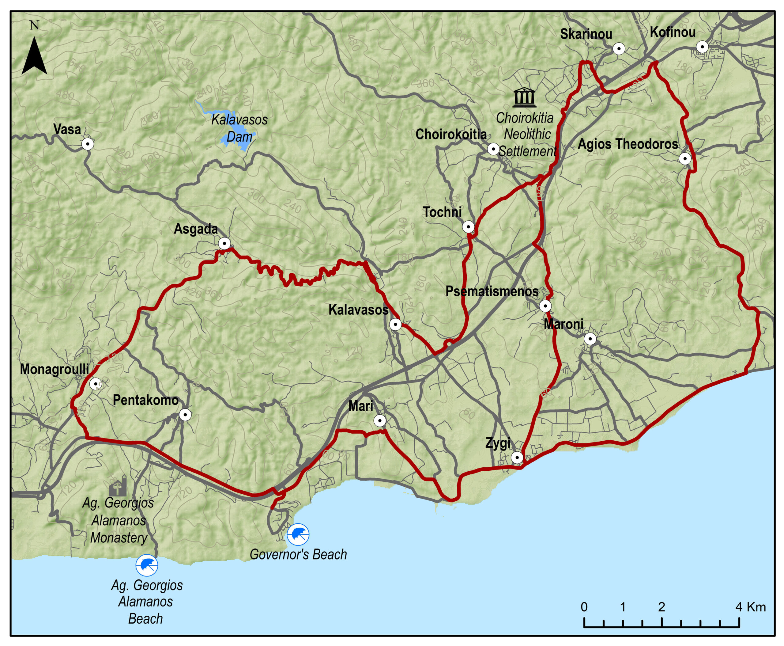
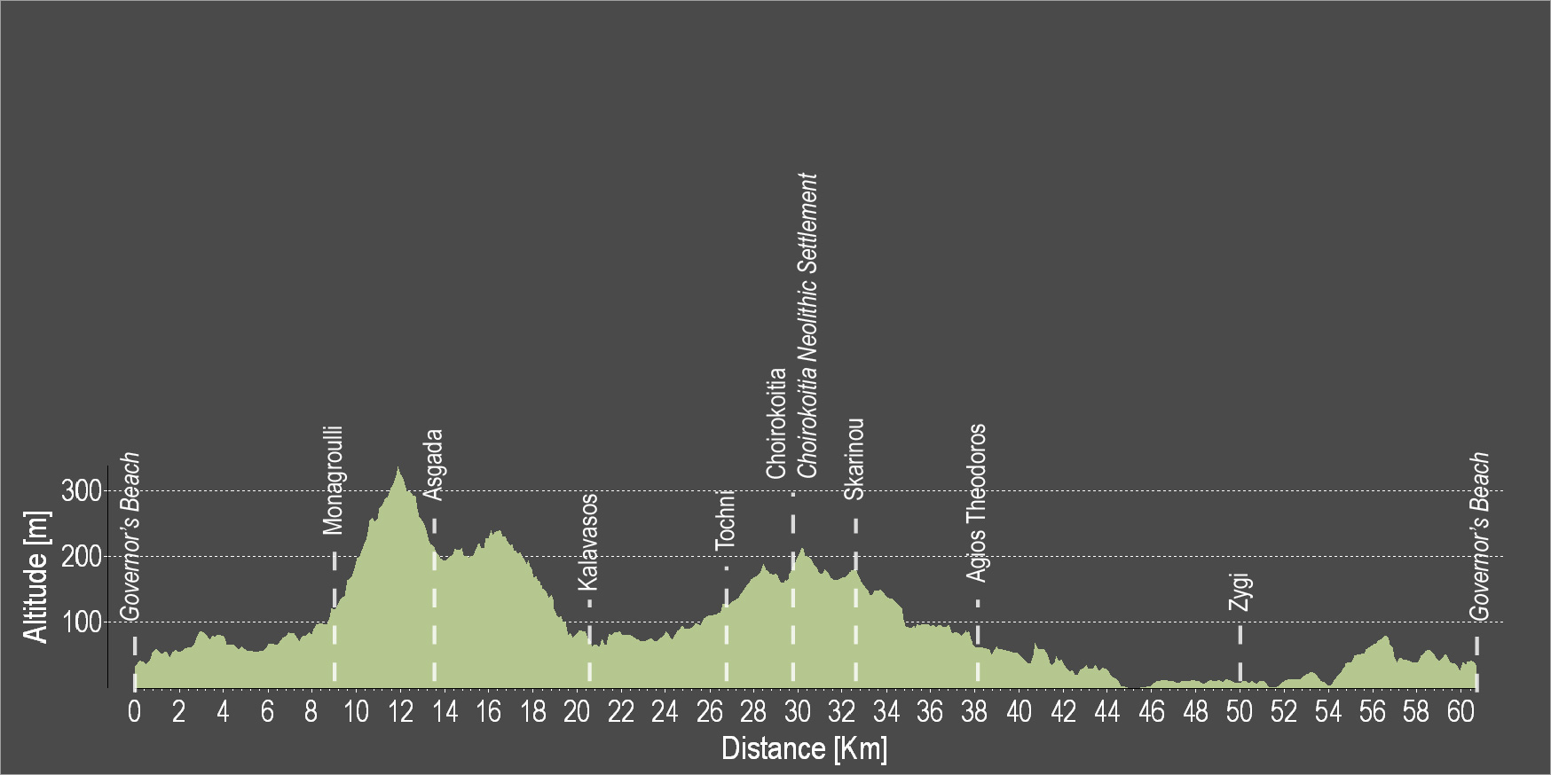
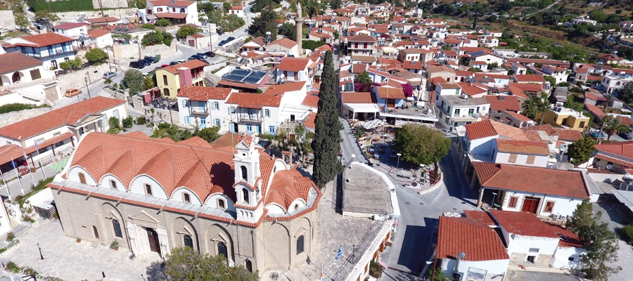
The route starts at the Governor’s Beach heading west to Monagroulli. A three kilometre uphill ride will lead to the beautiful village of Asgata. Pass through the narrow streets of the village and go downward to Kalavasos. The paved traditional streets, the grand church of the Virgin Mary and the Mosque are some of the many things to admire in Kalavasos. Then, head south and discover the village of Tochni where the ancient church of the village is bound to impress. The village of Choirokoitia is next, where the Neolithic Settlement of Choirokoitia is located, which has been listed as a UNESCO World Heritage Site since 1998. Skarinou and Agios Theodoros are the villages to follow before reaching Zygi and the Zygi Marina. Continue towards Vasiliko to finish the circular route at Governor’s Beach.
To download the route in gpx format click here
| Distance: | 60.2km |
| Elevation Gain: | 806m |
| Highest point: | 336m |
| Lowest point: | 3m |
| Loop: | YES |
| Terrain: | Mixed |
| Road surface: | Paved |
| Section Distance (km) | Total Distance (km) | |
| Governor’s Beach | 0.0 | 0.0 |
| Monagrouli | 8.5 | 8.5 |
| Asgada | 5.1 | 13.6 |
| Kalavasos | 6.7 | 20.3 |
| Tochni | 6.1 | 26.4 |
| Choirokoitia | 3.0 | 29.4 |
| Choirokoitia Neolithic Settlement | 0.0 | 29.4 |
| Skarinou | 3.1 | 32.5 |
| Agios Theodoros | 5.3 | 37.8 |
| Zygi | 12.4 | 50.2 |
| Governor’s Beach | 10.0 | 60.2 |
Ancient Vasilikos
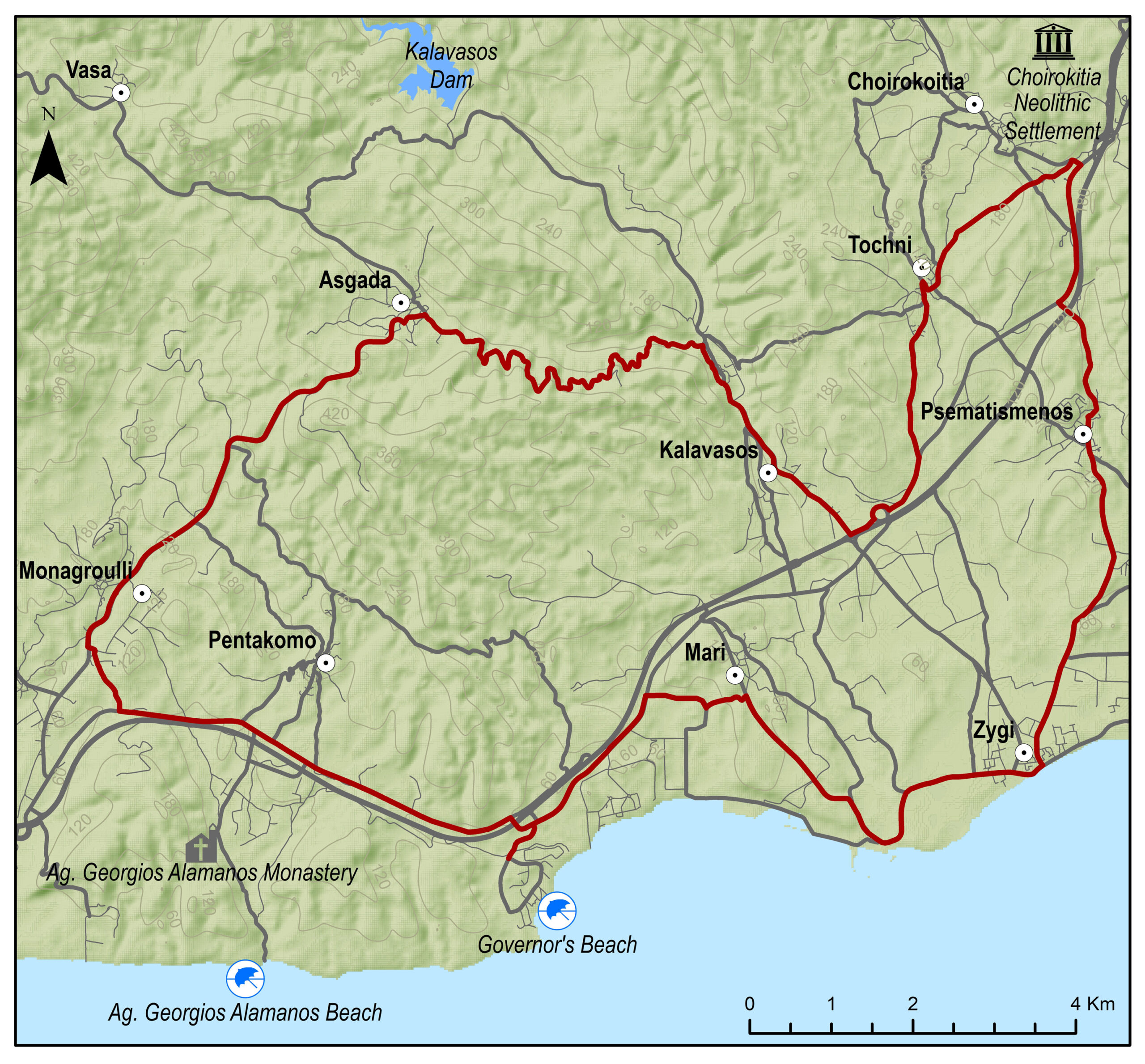
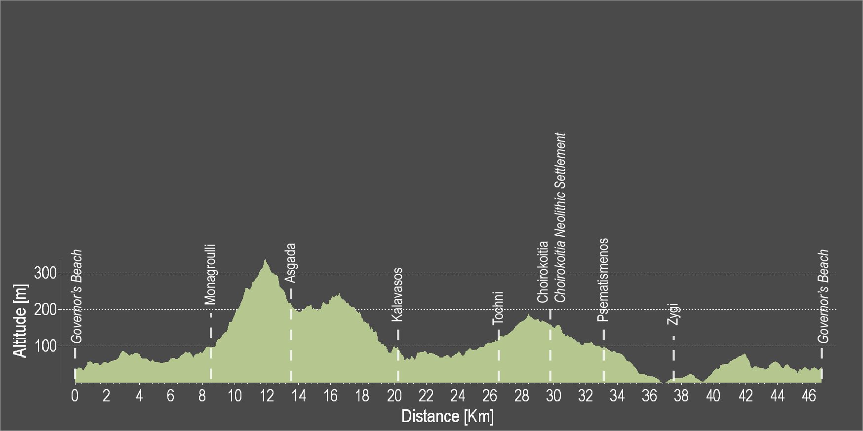
The route starts at the Governor’s Beach and heads westward to Monagroulli. A three kilometre uphill ride will lead to the beautiful village of Asgata. Pass through the narrow streets of the village and go downward to Kalavasos. The paved traditional streets, the grand church of the Virgin Mary and the Mosque are some of the many things to admire in Kalavasos. Then, head south and discover the village of Tochni where the ancient church of the village is bound to impress. Choirokoitia and Psematismenos are the villages to follow before reaching Zygi and the Zygi Marina. Continue towards Vasiliko to finish the circular route at Governor’s Beach.
To download the route in gpx format click here
| Distance: | 47.2km |
| Elevation Gain: | 677m |
| Highest point: | 338m |
| Lowest point: | 3m |
| Loop: | YES |
| Terrain: | Mixed |
| Road surface: | Paved |
| Section Distance (km) | Total Distance (km) | |
| Governor’s Beach | 0,0 | 0,0 |
| Monagroulli | 8.5 | 8.5 |
| Asgada | 5.1 | 13.6 |
| Kalavasos | 6.7 | 20.3 |
| Tochni | 6.1 | 26.4 |
| Choirokoitia | 3.0 | 29.4 |
| Choirokoitia Neollithic Settlement | 0.0 | 29.4 |
| Psematismenos | 3.3 | 32.7 |
| Zygi | 4.5 | 37.2 |
| Governor’s Beach | 10.0 | 47.2 |
Divine Coast
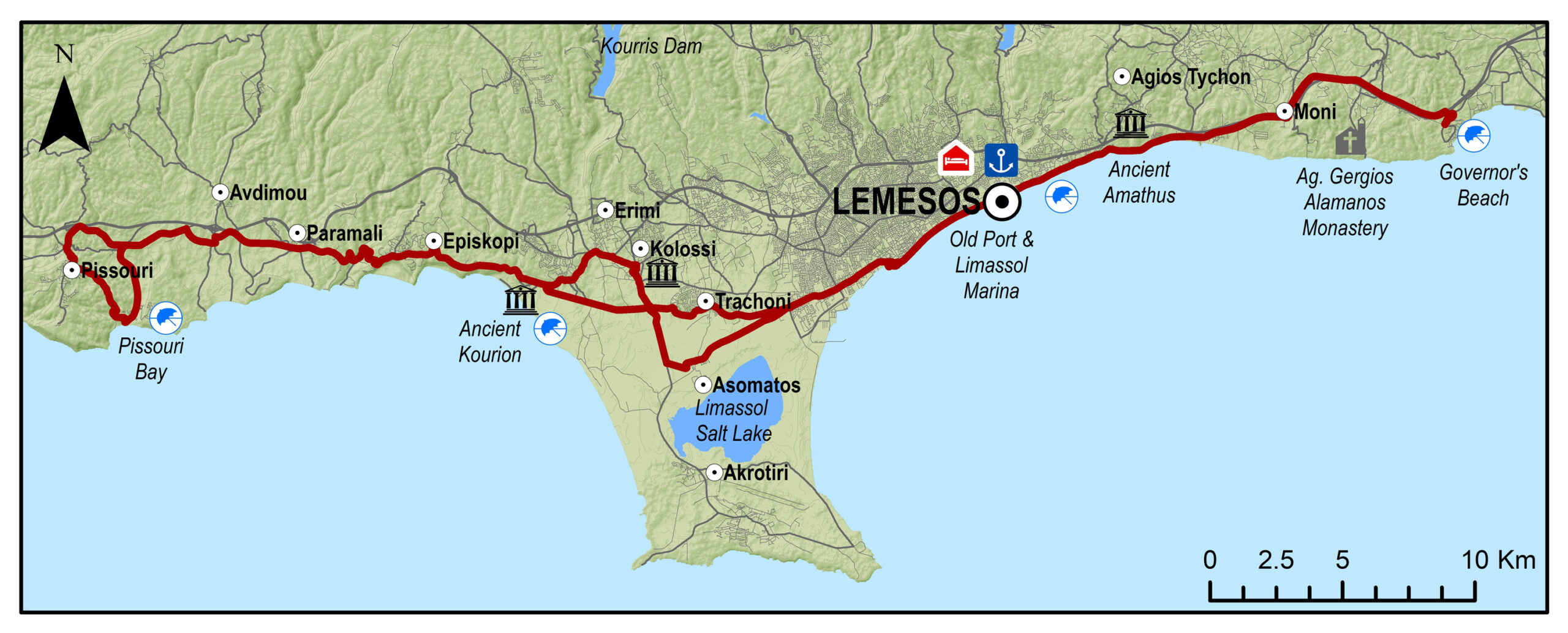
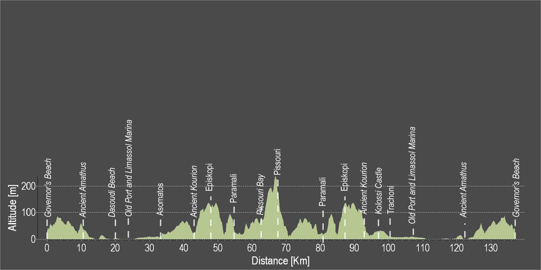
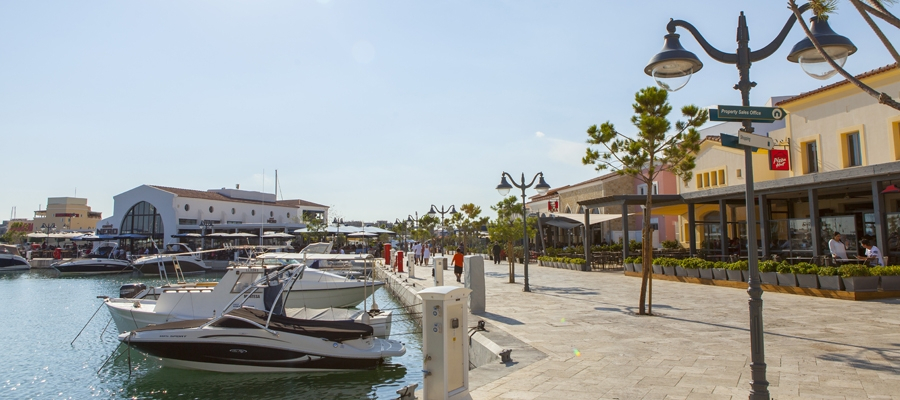
The route starts from Governor’s Beach and heads towards the coast and westward towards Lemesos. Cross Lemesos by going along the entire coastline of the city, from the Molos area, to the old port, to Limassol Marina, etc. Continue west and pass through the archaeological site of Kourion where the ancient theatre of Kourion is located. Ride uphill to the Sanctuary of Apollon Hylates and continue to reach the Episkopi and the Happy Valley. Pass through the Paramali village and end the route in Pissouri and Pissouri Bay.
To download the route in gpx format click here
| Distance: | 131.2km |
| Elevation Gain: | 1191m |
| Highest point: | 241m |
| Lowest point: | 2m |
| Loop: | YES |
| Terrain: | Mixed |
| Road surface: | Paved |
| Section Distance (km) | Total Distance (km) | |
| Governor’s Beach | 0,0 | 0,0 |
| Ancient Amathus | 10.5 | 10.5 |
| Dasoudi Beach | 9.5 | 20.0 |
| Old Port | 4.3 | 24.3 |
| Limassol Marina | 0.6 | 24.9 |
| asomatos | 8.2 | 33.1 |
| Ancient Kourion | 9.5 | 42.6 |
| Episkopi | 4.9 | 47.5 |
| Paramali | 5.6 | 53.1 |
| Pissouri Bay | 10.5 | 63.6 |
| Pissouri | 3.3 | 66.9 |
| Paramali | 11.5 | 78.4 |
| Episkopi | 5.5 | 83.9 |
| Ancient Kourion | 5 | 88.9 |
| Kolossi Castle | 5.5 | 94.4 |
| Trachoni | 4.6 | 99 |
| Limassol Marina | 7.2 | 106.2 |
| Old Port | 0.6 | 106.8 |
| Dasoudi Beach | 4.3 | 111.1 |
| Ancient Amathus | 10.5 | 121.6 |
| Governor’s Beach | 9.6 | 131.2 |