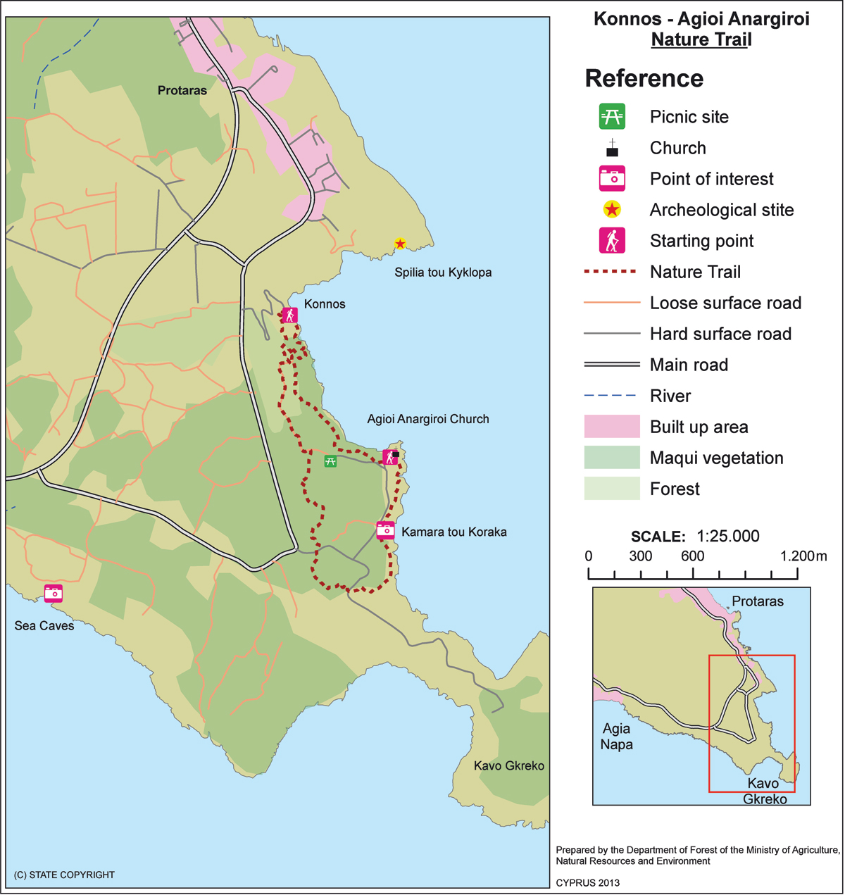
Konnoi ­- Agioi Anargyroi (Circular) – Ammochostos (Famagusta) District, Cape Gkreko National Forest Park Nature Trail

GPS coordinates of the starting point: Lat: 34.982763 Lon: 34.069620
GPS coordinates of the ending point: Lat: 34.975341 Lon: 34.075811
Altitude of the starting point: 3m
Altitude of the highest peak: 28m
Altitude of the end peak: 10m
Starting point: (a) Konnos Beach, between Protaras and Cape Gkreko
(b) Agioi Anargyroi church, accessible from the Protaras Cape Gkreko main road close to the Cape.
Length: 4.8km
Estimated duration: 2 hours
Difficulty rate: 1


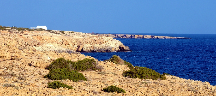
Points of interest: The trail affords excellent views throughout, with the views of the stunning Konnos Bay being particularly impressive. For the first two kilometres of the trail ­ beginning at Konnos Bay ­ the path continues parallel to the beach and arrives at the Agioi Anargyroi Church, which is built above a sea cave where it is said that the Saint Anargyroi lived an ascetic life. Following the trail to the south, through low shrub vegetation, it leads to the natural Kamara (arch) tou Koraka bridge ­ an impressive geological formation. After the bridge, the trail ascends slightly, passing through the ruins of the temple of Aphrodite, running parallel to the coastline through high shrub vegetation, and towards its end through a small pine forest.

Flora: While hiking you can study the endemic plants: Cyprus bosea (Bosea cypria), Wild garlic (Allium willeanum), Three colour chamomile (Anthemis tricolor), Cyprus Golden – Drop (Onosma fruticosa), Cyprus Germander (Teucrium micropodioides), ‘Valandia’ (Valantia eburnea).

Fauna: The main species of fauna found in the area are:

Mammals: Fox, hare, hedgehog.

Birds:  Kestler, partridge, Cyprus warbler  (endemic), Cyprus wheatear (endemic). The National Cape Gkreko Forest Park serves as a resting point for many migratory birds. Reptiles: Cyprus viper, Cyprus lizard, Cyprus chameleon, Black whip snake. 

Kyparissia ­- Ydatofraktis (dam) Germasogeias (Linear) – Lemesos (Limassol) District, Lemesos Forest Nature Trail

GPS coordinates of the starting point: Lat: 34.794998 Lon: 33.136578
GPS coordinates of the ending point: Lat: 34.759798 Lon: 33.104231
Altitude of the starting point: 562m
Altitude of the highest peak: 692m
Altitude of the end peak: 140m
Starting point: Around 3km from the main Parekklisia – Kellaki road.
Length: (a) 3.7km (circular), (b) 11km (ends at Germasogeia Dam)
Estimated duration: (a) 1.5 hour, (b) 3 – ­ 3.5 hours
Difficulty rate: (a) 2 (there is a steep downhill at the start), (b) 3 (there is a steep downhill at the start)


Points of interest: The trail initially passes through areas of forest and then continues for a short distance along the Kyparissia River, offering panoramic views of the Germasogeia dam and Lemesos (Limassol). The trail runs through a forest, with clusters of Cypress trees (Cupressus sempervirens var. horizontalis), and connects to the circular trail of Germasogeia dam. The Kyparissia Forest is a Natura 2000 site.

Flora: While hiking you can study the endemic plants: Entire – Leaved Horehound (Acanthoprasium integrifolium), Kakomallis Alison (Alyssum chondrogynum), Thyme (Thymus integer), Shrubby knapweed (Ptilostemon chamaepeuce subsp. cyprius), Cyprus Yellow Sun Rose (Helianthemum obtusifolium).

Fauna: The main species of fauna found in the area are:

Mammals: Fox, hare, hedgehog.

Birds:  Bonelli’s eagle, Wood pigeon, partridge, Cyprus warbler (endemic), Cyprus wheatear (endemic).

Reptiles: Cyprus viper, Cyprus lizard, Black whip snake.

Chrysovrysi (Linear) – Lemesos (Limassol) District,

GPS coordinates of the starting point: Lat: 34.929738 Lon: 32.924810
GPS coordinates of the ending point: Lat: 34.927571 Lon: 32.934557
Altitude of the starting point: 1,308m
Altitude of the highest peak: 1,315m
Altitude of the end peak: 1,068m
Starting point: Karvounas – Troodos road, 300 metres from Chrysovrysi Spring.
Length: 1.5km
Estimated duration: 1 hour
Difficulty rate: 2


Points of interest: Almost the entire trail is located within the Troodos National Forest Park, which is a Natura 2000 area. The last 300 metres of the trail are on a dirt road that is used by the residents of Amiantos for their agricultural operations. Gabbro rock formations, i.e. ultrabasic plutonic rocks belonging to the Troodos ophiolite complex, prevail along the trail. The route ends up on the Karvounas – Amiantos road, approximately 1.4 kilometres from the village of Amiantos. The A.G. Leventis Botanical Garden of Troodos and the Troodos Geopark Visitor Centre are located within the limits of the asbestos mine.

Flora: While hiking you can study the indigenous plants: plane (Platanus orientalis), Calabrian pine (Pinus brutia), strawberry tree (Arbutus adrachnae), terebinth (Pistacia terebinthus) and the endemic golden oak (Quercus alnifolia).


Loumata ton Aeton (Linear) – Lemesos (Limassol) District, Troodos Forest Nature Trail

GPS coordinates of the starting point: Lat: 34.915396 Lon: 32.931950
GPS coordinates of the ending point: Lat: 34.920130 Lon: 32.931465
Altitude of the starting point: 1,106m
Altitude of the highest peak: 1,106m
Altitude of the end peak: 1,012m
Starting point: The main road between Kato Amiantos village and SEK.
Length: 2.5km
Estimated duration: 1 hour
Difficulty rate: 2


Points of interest: The trail runs through a beautiful hillside and along the riverbank with lush vegetation, ending at Amiantos Park. It also passes the restored hide­out of the EOKA fighters and the stream Loumata ton Aeton. From linear, the trail becomes circular by following the roads through the village towards the summer camping site of S.E.K Trade Union Confederation. The trail is located within the Troodos National Forest Park.

Flora: While hiking you can study the indigenous plants: terebinth (Pistacia terebinthus), storax (Styrax officinalis), strawberry tree (Arbutus adrachnae), laurel (Laurus nobilis), myrtle (Myrtus communis), barberry  (Berberis cretica), oleander (Nerium oleander), honeysuckle (Lonicera etrusca), the common smilax (Smilax aspera), sage (Salvia fruticosa) and the endemic golden oak (Quercus alnifolia).

Fauna: The main species of fauna found in the area are:

Mammals: Fox, hare, hedgehog.

Birds: Bonelli’s eagle, Eurasian jay, Wood pigeon, partridge, Cyprus warbler  (endemic), Cyprus wheatear (endemic).

Reptiles: Cyprus viper, Cyprus lizard, Black whip snake, Montpellier snake.


Mnimata Piskopon (Linear) – Lefkosia (Nicosia) District, Troodos Forest Nature Trail

GPS coordinates of the starting point: Lat: 34.940102 Lon: 32.892387
GPS coordinates of the ending point: Lat: 34.975745 Lon: 32.888780
Altitude of the starting point: 1,723m
Altitude of the highest peak: 1,723m
Altitude of the end peak: 828m
Starting point: Along the road that leads to Kampos tou Livadiou picnic site.
Length: 8km
Estimated duration: 3 hours
Difficulty rate: 3 (smooth path at the beginning and downhill for the rest of the trail)


Points of interest: The trail passes through thickets of black pine and follows a route by the cliff’s edge, with views toward Chromium River, Solea Valley, Morfou Bay and the tip of Chionistra. The rich vegetation at the beginning of the trail, comprised of black pine and foetid juniper, gradually gives way to Calabrian pine at lower altitudes (below 1,400 metres). The whole trail is located within the Troodos National Forest Park, which is a Natura 2000 area. The route ends up on the Platania – Agios Nikolaos tis Stegis forest road. For the first kilometre the route is common with the Kampos tou Livadiou Trail. At the end of the trail you have the choice between three routes that end up at Agios Nikolaos tis Stegis, the village of Kakopetria or Platania Forest Station. ‘Kampos tou Livadiou’ picnic site, situated near the starting point, has potable water.

Flora: While hiking you can study the indigenous plants: white beam (Sorbus aria ssp. cretica), barberry (Berberis cretica), terebinth (Pistacia terebinthus), strawberry tree (Arbutus adrachnae) and the endemic golden oak (Quercus alnifolia).


Livadi (Circular) – Lefkosia (Nicosia) District, Troodos Forest Nature Trail

GPS coordinates of the starting point: Lat: 34.938829 Lon: 32.889990
GPS coordinates of the ending point: Lat: 34.938829 Lon: 32.889990
Altitude of the starting point: 1,711m
Altitude of the highest peak: 1,711m
Altitude of the end peak: 1,711m
Starting point: On the narrow asphalted road that leads to Kampos tou Livadiou picnic site.
Length: 1.5km
Estimated duration: 30 minutes
Difficulty rate: 1 (wheelchair accessible)


Points of interest: The Livadi Trail, which is wheelchair accessible, is located within Troodos National Forest Park – a Natura 2000 area. The course takes you through a black pine and foetid juniper forest, where you will have the chance to admire some century­ old trees. A viewpoint, where you can see Chromium River and Solea Valley, is available on the route. To complete the trail, turn back at the viewpoint and follow the same route for about 100 metres, then take the route on the right, as indicated by the sign. Tree loggings have not taken place in these forests since 1972, since the principal management objective for this forest area is the conservation of biodiversity, water resources and the landscape. ‘Kampos tou Livadiou’ picnic site has drinking water. The Troodos Visitor Centre, which holds information on the Troodos mountain range, its flora and its fauna, is located In Troodos Square.

Flora: While hiking you can study the endemic plants: Troodos viper­grass (Scorzonera troodea), Troodos spurge (Euphorbia cassia subsp. rigoi), golden oak (Quercus alnifolia), and the indigenous barberry (Berberis cretica), white beam (Sorbus aria ssp.cretica) and bracken (Pteridium aquilinum).


Kampos tou Livadiou (Circular) – Lemesos (Limassol) / Lefkosia (Nicosia) District, Troodos Forest Nature Trail

GPS coordinates of the starting point: Lat: 34.936231 Lon: 32.889129
GPS coordinates of the ending point: Lat: 34.936231 Lon: 32.889129
Altitude of the starting point: 1,680m
Altitude of the highest peak: 1,700m
Altitude of the end peak: 1,680m
Starting point: The road that leads to Kampos tou Livadiou picnic site.
Length: 3km
Estimated duration: 1.5 hour
Difficulty rate: 1 – 2


Points of interest: The first 1,000 metres of the trail are common with the Kampos tou Livadiou – Mnimata Piskopon Trail. With its positioning near the edge of a cliff, the trail offers views toward Chromium River, Solea Valley, Morfou Bay and the tip of Chionistra. It is particularly enjoyable as it passes through thickets of black pine and a significant number of century­ old black pines and junipers. There are also points of geological interest (dunite, harzburgite). The entire trail is located within the Troodos National Forest Park, which is a Natura 2000 area. The picnic site of ‘Kampos tou Livadiou’ has drinking water.

Flora: While hiking you can study the endemic plants: Cyprus skullcap (Scutellaria cypria subsp. cypria), Troodos Alyson (Alyssum troodi), golden oak (Quercus alnifolia), Troodos sage (Salvia willeana) and the indigenous barberry (Berberis cretica) and white beam (Sorbus aria ssp.cretica).


Trooditissa – Foini (Linear) – Lemesos (Limassol) District, Troodos Forest Nature Trail

GPS coordinates of the starting point: Lat: 34.912177 Lon: 32.837174
GPS coordinates of the ending point: Lat: 34.896838 Lon: 32.837357
Altitude of the starting point: 1,330m
Altitude of the highest peak: 1,330m
Altitude of the end peak: 944m
Starting point: The Platres – Prodromos main road.
Length: 4.5km
Estimated duration: 2 hours
Difficulty rate: 1


Points of interest: The route follows a forest road that connects Trooditissa Monastery with the beautiful village of Foini, with exceptional views towards the village along the way. The trail crosses the Trooditissa River and leads you to the route’s main attraction, the Chantara waterfall (eight metres high), then passes by vertical cliffs before the journey ends on the Foini – Agios Dimitrios road, right outside Foini. The entire trail is located within Troodos National Forest Park, which is a Natura 2000 area.

Flora: While hiking you can study (amongst other plants) the indigenous plants: Calabrian pine (Pinus brutia), strawberry tree (Arbutus adrachnae), and the endemic golden oak (Quercus alnifolia).


Psilondentro (Tall Tree) – Pouziaris (Circular) ­- Lemesos (Limassol) District, Troodos Forest Nature Trail

GPS coordinates of the starting point: Lat: 34.895957 Lon: 32.869154
GPS coordinates of the ending point: Lat: 34.920633 Lon: 32.881826
Altitude of the starting point: 1,178m
Altitude of the highest peak: 1,718m
Altitude of the end peak: 1,178m
Starting point: The crossing point of the forest road Platres – Mesa Potamos with the tourist road Moniatis – Platres – Troodos, close to the Psilodentro (Tall Tree).
Length: 9km
Estimated duration: 3 – 4 hours
Difficulty rate: 3 (very challenging due to the uphill and downhill areas of the route)


Points of interest: For the first kilometre, the path passes through dense clusters of Calabrian pine trees, whilst on the third kilometre at the points with a higher altitude it passes through an impressive and dense black pine forest (Pinus nigra subsp.pallasiana). At points along the trail you will experience panoramic views. The path is located within the National Forest Park of Troodos.

Flora: While hiking you can study the endemic plants: Golden oak (Quercus alnifolia), Purple Rock Cress (Arabis purpurea), Manouthkia (Pterocephalus multiflorus subsp. multiflorus – an evergreen small shrub with pale pink flowers), Cyprus Skullcap (Scutellaria cypria subsp. cypria), Troodos Sage (Salvia willeana).

Fauna: The main species of fauna found in the area are:

Mammals: Fox, hare, hedgehog.

Birds: Bonelli’s eagle, Eurasian jay, Wood pigeon, partridge, Cyprus warbler (endemic), Cyprus wheatear (endemic).

Reptiles: Cyprus viper, Cyprus snake (endemic), Cyprus lizard.

Kalidonia (Linear) – Lemesos (Limassol) District, Troodos Forest Nature Trail

GPS coordinates of the starting point: Lat: 34.914670 Lon: 32.870569
GPS coordinates of the ending point: Lat: 34.895785 Lon: 32.868541
Altitude of the starting point: 1,571m
Altitude of the highest peak: 1,571m
Altitude of the end peak: 1,238m
Starting point: (a) 350m from the main road of Troodos Square ­ Platres, 3km from the square. You can also access the starting point from the old Troodos ­ Platres road, after the Presidential Summer Residence
(b) At the Psilodentro (Tall Tree) above Pano (Upper) Platres.
Length: 3km
Estimated duration: 1.5 hour
Difficulty rate: 3


Points of interest: From the starting point (a) the trail passes through a dense forest and then runs alongside the Cold River (Krios Potamos), which has running water all year round. It then passes by the Kalidonia Waterfall and finishes at the Psilodentro in Pano Platres. The trail is located within the Troodos National Forest Park. In Troodos Square you will find the Environmental Information Centre for the Troodos National Forest Park.

Flora: While hiking you can study the endemic plants: Troodos sage (Salvia willeana), Purple Rock ­ Cress (Arabis purpurea), Thorny gorse (Genista fasselata subsp. crudelis), Urse mint (Mentha longifolia subsp. cyprica), Aphrodite’s spurge (Euphorbia veneris), Golden oak (Quercus alnifolia).

Fauna: The main species of fauna found in the area are:

Mammals: Fox, hare, hedgehog.

Birds: Bonelli’s eagle, Eurasian jay, Wood pigeon, partridge, Cyprus warbler (endemic), Cyprus wheatear (endemic).

Reptiles: Cyprus viper, Cyprus snake (endemic).