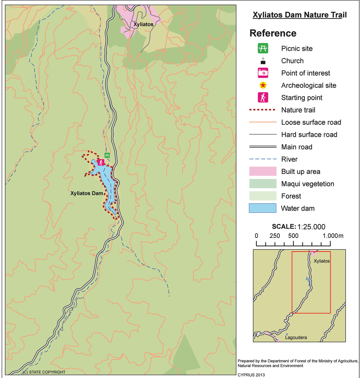
Xyliatos (Circular) – Lefkosia (Nicosia) District, Adelfoi Forest Nature Trail

GPS coordinates of the starting point: Lat: 35.009318 Lon: 33.036420
GPS coordinates of the ending point: Lat: 35.009318 Lon: 33.036420
Altitude of the starting point: 543m
Altitude of the highest peak: 601m
Altitude of the end peak: 543m
Starting point: (a) The overflow of the dam, (b) The dam’s picnic site.
Length: 3.8km
Estimated duration: 1 – 1.5 hour
Difficulty rate: 2


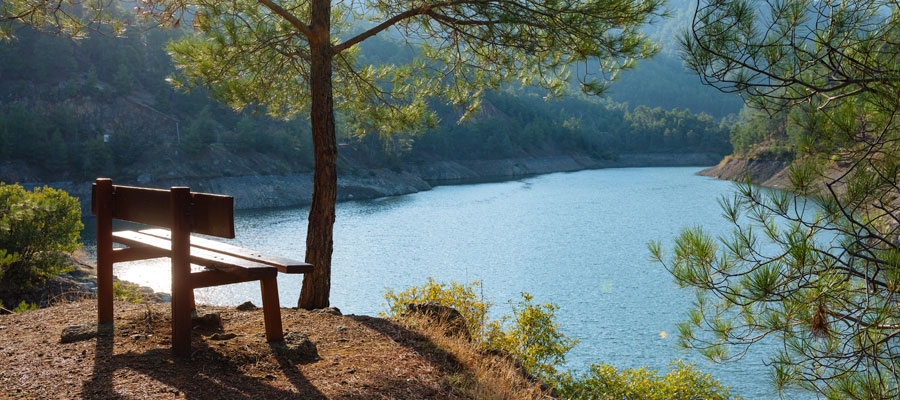
Points of interest: The trail begins at the overflow of the dam and runs alongside the highest water level point of the dam. It then crosses the artificial bridge over the dam. The uphill trail takes you to the Xyliatos – ­Lagoudera road, which leads you to the starting point if you follow through the dam’s embankment. The trail connects with another 200-metre trail, which starts from the picnic site ‘Fraktis tou Xyliatou’ (Xyliatos Dam) then follows a small section of the Xyliatos – ­Lagoudera road, joining with the circular path at the dam’s embankment. The dam itself is also of interest. A section of the path passes through a pine forest where you will encounter varieties of the golden oak tree, strawberry tree, myrtle, oriental alder and rockrose.

Flora: While hiking you can study the endemic plants: Shrubby knapweed (Ptilostemon chamaepeuce var. cyprius), Purple Rock ­ Cress (Arabis purpurea), ‘Manouthkia’ (Pterocephalus multiflorus subsp. multiflorus – an evergreen small shrub with pale pink flowers), Cyprus skullcap (Scutellaria cypria subsp. elatior), Thyme (Thymus integer), Wild garlic (Allium willeanum).

Fauna: The main species of fauna found in the area are:

Mammals: Fox, hare, hedgehog.

Birds: Bonelli’s eagle, Wood pigeon, partridge, Cyprus warbler (endemic), Cyprus wheatear (endemic).

Fish: Trout, carp, bass.

Amphibians: Frogs.

Kionia – Profitis Ilias (Linear) – Lefkosia (Nicosia) District, Machairas Forest Nature Trail

GPS coordinates of the starting point: Lat: 34.920214 Lon: 33.197602
GPS coordinates of the ending point: Lat: 34.933480 Lon: 33.246317
Altitude of the starting point: 1,251m
Altitude of the highest peak: 1,251m
Altitude of the end peak: 677m
Starting point: Kionia picnic site. There are two access points to the trail- one from the Machairas monastery road that leads to Kionia, and the other from the Vavatsinia to Machairas road.
Length: 7km
Estimated duration: 2.5 hours
Difficulty rate: 3 (steep downhill path, especially towards the end)


Points of interest: The trail starts at the Kionia picnic site, where you can find a fountain with drinking water, and runs through a forest section where it affords great views of the Mesaoria plain, which belongs to the Machairas National Forest Park a Natura 2000 site. There is a perennial strawberry tree on the trail, whilst the picnic site boasts perennial pine and arar trees. The trail ends at the Profitis Ilias picnic site, approximately eight kilometres from Lythrodontas and six kilometres from Mandra tou Kambiou, via dirt roads.

Flora: While hiking you can study the endemic plants: Shrubby knapweed (Ptilostemon chamaepeuce var. cyprius), Golden oak (Quercus alnifolia), Purple Rock ­ Cress (Arabis purpurea), ‘Manouthkia’ (Pterocephalus multiflorus subsp. multiflorus – an evergreen small shrub with pale pink flowers).

Fauna: The main species of fauna found in the area are:

Mammals: Fox, hare, hedgehog.

Birds: Bonelli’s eagle, Eurasian jay, Wood pigeon, Partridge, Cyprus warbler  (endemic),

Cyprus wheatear (endemic).

Reptiles: Cyprus viper, Black whip Snake, Cyprus lizard.

Avakas Gorge (Linear) – Pafos (Paphos) District, Akamas Forest – Nature Trails

GPS coordinates of the starting point: Lat: 34.920499 Lon: 32.337698
Altitude of the starting point: 47m
Altitude of the highest peak: 45m
Altitude of the end peak: 45m
Starting point: Avakas Gorge, following the Agios Georgios Pegeias – Toxeftra road for 2.5km and heading east from where Toxeftra Bay begins.
Length: 1.2km
Estimated duration: 45 minutes
Difficulty rate: 1 – 2


Points of interest: The Avakas Gorge Trail is located in the homonymous gorge, within Pegeia state forest with the end of the trail located inside the gorge. It follows the course of the Avgas River, from where the gorge gets its name and resulted from constant erosive activity on the erodible, sloping limestone rocks composed of loams, chalks, reef and grain limestone and bentonitic clays. The gorge is also a Natura 2000 area. The trail firstly follows a dirt road (closed to private vehicles) through an open valley, then takes you into the gorge. In its last section, the trail is in the stream, in which water usually flows throughout the year. The route through the gorge is characterised by thick vegetation and a particularly attractive, shady and moist environment.

Flora: While hiking you can study the indigenous plants: lentisk (Pistacia lentiscus), Phoenician juniper (Juniperus phoenicea), terebinth (Pistacia terebinthus), thorny broom (Calycotome villosa), common smilax (Smilax aspera), oleander (Nerium oleander), storax (Styrax officinalis), and the endemic endangered Akamas centaury (Centaurea akamantis).

Fauna: The main species of fauna found in the area are:

Mammals: Fox, hare, hedgehog. Birds: Cyprus wheatear (endemic), Cyprus warbler (endemic), scops owl (endemic), partridge, little owl, kestrel, wild pigeon.

Reptiles: Stellion lizard. Amphibians: Marsh frog, iridescent frog, tree frog.

Pissouromoutti (Circular) – Pafos (Paphos) District, Akamas Forest Nature Trail

GPS coordinates of the starting point: Lat: 35.023417 Lon: 32.333405
GPS coordinates of the ending point: Lat: 35.023417 Lon: 32.333405
Altitude of the starting point: 285m
Altitude of the highest peak: 400m
Altitude of the end peak: 285m
Starting point: Smigies picnic site.
Length: 3km
Estimated duration: 2 hours
Difficulty rate: 2 (upward and downward gradients around the hill)


Points of interest: There are many points of exceptional view along the trail, but the most impressive view is from the top of the hill. Here, you can seamlessly enjoy nature all around you (toward the south coast: Tzioni, Geranissos, Lara, Agios Georgios Pegeias, and toward the north coast: Chrysochou Bay). Part of the trail passes through a pine forest that offers shade on warm summer days, making the walk particularly unique and enjoyable. Smigies picnic site has drinking water flowing directly to the area from a spring.

Flora: While hiking you can study the indigenous plants: Phoenician juniper (Juniperus phoenicea), lentisk (Pistacia lentiscus), terebinths (Pistacia terebinthus), rockroses (Cistus creticus, Cistus monspeliensis etc), wild thyme (Thymus capitatus).


Smigies (Circular) – Pafos (Paphos) District, Akamas Forest Nature Trail

GPS coordinates of the starting point: Lat: 35.024020 Lon: 32.333115
GPS coordinates of the ending point: Lat: 35.024020 Lon: 32.333115
Altitude of the starting point: 273m
Altitude of the highest peak: 388m
Altitude of the end peak: 273m
Starting point: Smigies picnic site, 2.5km from Neo Chorio, within the Akamas region.
Length: a) Short route: 2.5km, (b) Long route: 6km
Estimated duration: (a) Short route: 1 hour, (b) Long route: 2 hours
Difficulty rate: 2


Points of interest: Initially, the trail offers beautiful views of the coastline of the Akamas peninsula to the west ­ including Lara Bay ­ and later on, to the east, with views of Chrysochous bay in the direction of Latsi, Polis, Pachyammos and Pafos (Paphos) forest. The longer route runs past the old mines, magnesium facilities, and abandoned kilns, and through a dense section of the Akamas forest. The trail also connects with the Adonis trail at Kefalovrisia, where you will find a non­ potable water fountain. At the starting point, the two routes are adjacent to the walking trail of Pissouromoutti. Both routes pass by the Piana fire lookout station of the Forestry Department.

Flora: While hiking you can study the endemic plants: Thyme (Thymus integer), Cyprus germander (Teucrium micropodiodes), Cyprus Golden – Drop (Onosma fruticosa), Entire – Leaved Horehound (Acanthoprasium integrifolium), Sweet Marjoram (Origanum majorana var. tenuifolium).

Fauna: The main species of fauna found in the area are:

Mammals: Fox, hare, hedgehog.

Birds: Wood pigeon, partridge, Cyprus warbler (endemic), Cyprus wheatear (endemic).

The Forest of Akamas serves as a resting point for many migratory birds.

Reptiles: Cyprus viper, Cyprus lizard, Black whip snake.


Aphrodite (Circular) – Pafos (Paphos) District, Akamas Forest Nature Trail (Rural)

GPS coordinates of the starting point: Lat: 35.056063 Lon: 32.345565
GPS coordinates of the ending point: Lat: 35.056063 Lon: 32.345565
Altitude of the starting point: 35m
Altitude of the highest peak: 333m
Altitude of the end peak: 35m
Starting point: The Loutra tis Afroditis (Baths of Aphrodite).
Length: 7.5km
Estimated duration: 3 – 4 hours
Difficulty rate: 3


Points of interest: Of special interest on this trail are the Loutra tis Afroditis (Baths of Aphrodite), where, according to legend, the Goddess of Love and Beauty used to take her baths. You will also pass by the ruins of Pyrgos tis Rigainas (Queen’s Tower), which are believed to belong to a Medieval monastery. Also noteworthy is a 500­ year­ old oak tree, which is located near the ruins of the tower. Along the trail you can enjoy excellent views of Cape Arnaoutis, Polis Chrysochous and Pafos (Paphos) Forest. There are two non­ potable water fountains along the trail; one near the ruins of Pyrgos tis Rigainas, and another between the Loutra tis Afroditis (Baths of Aphrodite) and Kakoskali. The trail connects with the Adonis trail, whilst at its starting point you can visit the Botanical Gardens of Akamas. 

Flora: While hiking you can study the endemic plants: Cyprus Golden – Drop (Onosma fruticosa), Cyprus sage (Phlomis cypria var. occidentalis).

Fauna: The main species of fauna found in the area are:

Mammals: Fox, hare, hedgehog.

Birds: Wood pigeon, partridge, Cyprus warbler  (endemic), Cyprus wheatear (endemic).

The forest serves as a resting point for many migratory birds.

Reptiles: Cyprus viper, Cyprus lizard, Black whip Snake.


Adonis (Circular) – Pafos (Paphos) District – Akamas

GPS coordinates of the starting point: Lat: 35.056063 Lon: 32.345565
GPS coordinates of the ending point: Lat: 35.056063 Lon: 32.345565
Altitude of the starting point: 35m
Altitude of the highest peak: 319m
Altitude of the end peak: 35m
Starting point: 400m before the Loutra tis Afroditis (Baths of Aphrodite).
Length: 7.5km
Estimated duration: 3 – 4 hours
Difficulty rate: 3


Points of interest: This trail offers beautiful views of Polis Chrysochous, the Pafos (Paphos) Forest and the Akamas peninsula. The path runs past Pyrgos tis Rigainas (Queen’s Tower) and connects with the Smigies trail at Kefalovrysia (where there is a fountain of non­ potable water), and with the Afroditi trail at Pyrgos tis Rigainas. Also noteworthy is the 500 ­year­ old oak tree, which is located near the ruins of the tower. To return full circle, the trail follows the main road that connects the Loutra tis Afroditis (Baths of Aphrodite) with Polis for about 400 metres. At the starting point of the trail you can visit the Botanical Gardens of Akamas.

Flora: While hiking you can study the endemic plants: Cyprus Bosea (Bosea cypria), Shrubby knapweed (Ptilostemon chamaepeuce var. cyprius), Entire – Leaved Horehound (Acanthoprasium integrifolium), Sweet Marjoram (Origanum majorana var. tenuifolium), Cyprus Golden ­ Drop (Onosma fruticosa), Cyprus sage (Phlomis cypria var. occidentalis).

Fauna: The main species of fauna found in the area are:

Mammals: Fox, hare, hedgehog.

Birds: Wood pigeon, partridge, Cyprus warbler (endemic), Cyprus wheatear (endemic).

The forest of Akamas serves as a resting point for many migratory birds.

Reptiles: Cyprus viper, Cyprus lizard, Black whip Snake.

Troodos Square – Stavros tis Psokas Cycling Route

Linking the Troodos area with the Kykkos Mountains, this 55km route also allows further trips to the northwest coast of the island, along the route from Stavros to Pyrgos or to Polis.

The route begins in Troodos Square and climbs to the west for about 2,5km when it reaches a turning to the left leading to Mount Olympos. From here, it travels downhill to the village of Prodromos. It then turns right to the Pinewood area and travels above the village of Pedoulas to Kykkos Monastery. At this point there is an opportunity to stop at the Kykkos restaurant before going on to Kampos. A turning to the left before Kampos leads to Stavros tis Psokas to the west and 3,5km further down, another turning to the left leads to the Cedar Valley. The route continues straight on for another 16km until another turning to the left, leading to Stavros tis Psokas forestry station 3km along the way. Here, there is a restaurant, a hostel, a picnic site and a camping site, as well as a fenced off area where moufflon (indigenous mountain goats) are kept.

Start Point: Troodos Square
End Point: Stavros tis Psokas
Total Distance: 55km
Height Gain: 25m
Difficulty Rating: An easy route with a few uphills and plenty of downhills. Requires a street bike with speeds.
Road Conditions: Paved roads throughout
 

Troodos – Pafos (Paphos) Cycling Route

This 65km route links the Troodos area to Pafos (Paphos) via the picturesque villages of the Diarizos River Valley.

From Troodos Square the route heads south along the main Lemesos (Limassol) – Troodos road. At Psilo Dendro it turns right to Pano Platres and then on to Kato Platres. Just outside the village it turns right for Mandria and Pafos. Heading southwest the route goes through Mandria and enters the Diarizos Valley, passing through the villages of Agios Nikolaos, Praitori, Kedares, Kidasi, Agios Georgios, Mamonia, Fasoula and Nikokleia, and finally joins the old Lemesos – Pafos road. From there it turns west to reach Pafos via the villages of Mandria, Timi, Acheleia and Geroskipou.

Start Point: Troodos Square
End Point: Pafos
Total Distance: 65km
Height Gain: 20m
Difficulty Rating: An easy route, mostly downhill. Requires good brakes whether street or mountain bike.
Road Conditions: Paved road throughout.
 

Psilo Dendro (Platres) – Karvounas Cycling Route

Karvounas is one of the main junctions of the Troodos cycling network. It forms the administrative boundary between Lemesos (Limassol) district to the south and Lefkosia (Nicosia) district to the north.

All seven rest and viewpoints are located along the first 9km of the route, overlooking Platres Valley and linking it with Moniatis. The southern shores of the island and the city of Lemesos stretch out in the distance, and the horizon extends as far as Cape Gata.

The route crosses the Mesa Potamos River 6km from the starting point. The dense vegetation in this corner of the eastern slopes of the mountain range of Troodos creates a cool, almost chilly environment that is a welcome respite in the hottest summer months. There are rest benches, and fresh running water is freely available for visitors to drink when they stop here for a well­earned break.

The nearby village of Pano Platres, 1km away, provides hotel and other tourist accommodation, restaurants, cafes, banks and shops.

Start Point: Psilo Dendro, Platres
End Point: Karvounas
Total Distance: 16,2km
Difficulty Rating: An easy route with good accessibility by bicycle.
Road Conditions: Good quality tarmac and forest dirt track in good condition (Depending on weather conditions).