Deryneia Folkloric Museum / Open Air Museum for Traditional Professions

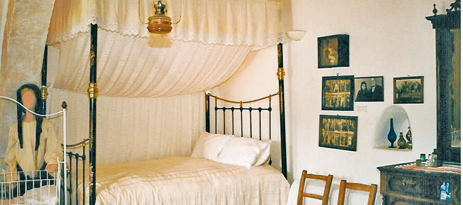
Housed in an old traditional residence, Deryneia Folk Art Museum exhibits a collection of everyday agricultural tools and equipment used by traditional farming families of bygone times.

Located opposite is the Open Air Traditional Folk Art Museum which further showcases traditional professions in its exhibition rooms, including that of furniture and shoe maker, carpenter, tailor, blacksmith, builder, barber, sculptor, fisherman and farmer, among others. Exhibitions are also held on the grounds, along with civil marriages and other cultural events.

Region: Ammochostos (Famagusta)
Address: Demetri Liberti 2 & 3, Deryneia village
Contact No: Tel: +357 23 811 000
Operating Hours: Winter: Monday – ­ Saturday: 09:00 – 13:00 / 15:00 – ­17:00
Summer: Monday – ­ Saturday: 09:00 – 13:00 / 15:00 -­ 18:00
Closed on Sunday.
Operating Period: All year round.
Closed on Public Holidays.
Entrance Fee: €2,00 / Groups €1,00 (both museums)
Disabled Access: Wheelchair accessible
Website: www.visitfamagusta.com.cy
  Opening and closing times as well as entrance fees, are subject to alterations without notice. Visitors are advised to check before visiting.
 

Thalassa Agia Napa Municipal Museum

Named after the Greek word for ‘sea’ – the Thalassa Museum was created to promote awareness of the marine heritage of Cyprus from prehistoric times to the present, and is a modern, interactive museum, housed in a multi­purpose cultural centre.

Pride of place among the exhibits is a life­size replica of the famous 4th century Greek trading ship ‘Keryneia II’ that sank off the coast of Keryneia around the year 300 BC. Due to the museum’s design, the ship can be viewed from different levels, including a birds­eye view – as can the other exhibits, that include pottery and other antiquities.

Housed in the basement is a marine life section with various exhibits, from fish and sea mammals to crustaceans, corals, shells and fossils – some dating back 130 million years ago.

The museum also functions as an arts exhibition centre, as well as a multipurpose hall for a variety of events and conferences.

Region: Ammochostos (Famagusta)
Address: Leoforos Kryou Nerou, 14, Agia Napa
GPS coordinates: Lat: 34.987634 Lon: 34.002424
Contact No: Tel: +357 23 816 366, Fax: +357 23 816 369
Operating Hours: October – May: Monday: 09:00 – 13:00, Tuesday – Saturday: 09:00 – 17:00, Sunday: closed
June – September: Monday: 09:00 – 13:00, Tuesday – Saturday: 09:00 – 17:00, Sunday: 15:00 – 19:00
Operating Period: All year round.
Closed on Public Holidays.
Entrance Fee: Adults €4,00 / Children €1,50
Special rates for students and groups.
Disabled Access: Wheelchair accessible.
Website: https://thalassamuseum.org.cy/
  Opening and closing times as well as entrance fees, are subject to alterations without notice. Visitors are advised to check before visiting.
 

The Avgorou Ethnographic Museum

The Ethnographic Museum in the village of Avgorou is housed in a 1921 two­storey, traditional residence (the Koutras House), and depicts the daily life of previous generations.

Amongst its exhibits are rare 19th century wood­carved furniture, costumes, silverware and pottery, a collection of paintings by self­taught Cypriot artists, and priceless traditional textiles and embroideries of the 18th – 19th century, as well as many other traditional utensils and tools.

The museum also has a large courtyard, stockyard, water reservoir and wheel­well.

Region: Ammochostos (Famagusta)
Address: Leoforos Karyon, 52, Avgorou village
GPS coordinates: Lat: 35.0395 Lon: 33.83987
Contact No: Tel: +357 23 923 340
Operating Hours: Monday – Friday: 08:30 – 13:30
Tuesday, Thursday, Friday: 16:00 – 18:00
Saturday: 09:00 – 13:00
Closed on Sunday.
Operating Period: All year round.
Closed on Public Holidays.
Entrance Fee: Adults €1,71 / Children €0,86
Special rates for students and groups.
  Opening and closing times as well as entrance fees, are subject to alterations without notice. Visitors are advised to check before visiting.
 

Sea Caves – Agioi Anargyroi (Linear) – Ammochostos (Famagusta) District, Cape Gkreko National Forest Park Nature Trail

GPS coordinates of the starting point: Lat: 34.975349 Lon: 34.075822
Altitude of the starting point: 13m
Altitude of the highest peak: 30m
Altitude of the end peak: 13m
Starting point: (a) the Sea Caves / (b) Agioi Anargyroi Church.
Length: 4km
Estimated duration: 1.5 hour
Difficulty rate: 1


Points of interest: The Sea Caves – Agioi Anargyroi Trail is located on the cape of Cape Gkreko, within the National Forest Park, which is a Natura 2000 area. A big part of the route runs parallel to the shoreline. From the Sea Caves to Kavos hill the trail passes through a rocky area with sparse halophytic vegetation. It then follows a course due north, through low shrubby vegetation. Passing through an area of fields planted with cereals ­ and through an area of low bushes ­ the trail reaches a natural bridge called ‘Kamara tou Koraka’ and ends up at Agioi Anargyroi Church. The church is built over a sea cave, where it is believed that saints (known as Agioi Anargyroi) lived as ascetics. The trail connects to the Konnoi – Agioi Anargyroi Trail, and to the Aphrodite Trail. About 200 metres to the west of the end of trail, there is a picnic site with drinking water.

Flora: While hiking you can study the plants: prickly burnet (Sarcopoterium spinosum), wild thyme (Thymus capitatus), rock samphires (Crithmum maritimum), lentisk (Pistacia lentiscus), wild olive (Olea europaea).

Aphrodite (Circular), Ammochostos (Famagusta) District, Cape Gkreko National Forest Park Nature Trail Agia Napa

GPS coordinates of the starting point: Lat: 34.982762 Lon: 34.069630
GPS coordinates of the ending point: Lat: 34.982762 Lon: 34.069630
Altitude of the starting point: 10m
Altitude of the highest peak: 60m
Altitude of the end peak: 10m
Starting point: Visitor Centre parking site.
Length: 2km
Estimated duration: 1 hour
Difficulty rate: 1


Points of interest: The Aphrodite Trail is located within the Cape Gkreko National Forest Park and follows a downhill incline until it reaches the beach. Here, it connects to the Sea Caves – Agioi Anargyroi Trail and before it reaches a natural bridge called ‘Kamara tou Koraka’ it takes an uphill turn toward the Visitor Centre. This part of the trail is common with the Konnoi – Agioi Anargyroi. The first part of the trail passes by the ruins of the ancient temple, dedicated to the Goddess of Love and Beauty, Aphrodite. On the way to the beach, the trail passes by natural caves with dry stone walls built around their perimeter – constructions that were used by shepherds to keep animals. There are many viewpoints along the route. There is also a sign with the Cypria Aphrodite (Κύπριδα Αφροδίτη) logo indicating where an ancient temple dedicated to the Goddess Aphrodite is believed to have been.

Flora: While hiking you can study the indigenous plants: Phoenician juniper (Juniperus phoenicea), wild thyme (Thymus capitatus), prickly burnet (Sarcopoterium spinosum), rock samphires (Crithmum maritimum).

Konnoi – Cyclops Cave (Circular) – Ammochostos (Famagusta) District, Cape Gkreko National Forest Park Nature Trail

GPS coordinates of the starting point: Lat: 34.984287 Lon: 34.068423
GPS coordinates of the ending point: Lat: 34.984287 Lon: 34.068423
Altitude of the starting point: 27m
Altitude of the highest peak: 30m
Altitude of the end peak: 27m
Starting point: Konnos beach parking area.
Length: 1.7km
Estimated duration: 45 minutes
Difficulty rate: 1


Points of interest: The Konnoi – Cyclops Cave Trail is situated within the Cape Gkreko National Forest Park, which is a Natura 2000 area. The trail follows a route parallel to the rugged shore. Passing through mostly shrubby vegetation, it reaches the natural Cyclops Cave. The return route is on the same trail for about 250 metres. It then follows a downward path toward the beach and finally an uphill climb back to the starting point. All along the trail, there is a seamless view of the turquoise waters and golden sands of Konnos beach, as well as of Agioi Anargyroi church.

Flora: While hiking you can study the plants: coastal boxthorn (Lycium schweinfurthii), prickly burnets (Sarcopoterium spinosum), Phoenician juniper trees (Juniperus phoenicea), acacia trees (Acacia sp.).


Konnoi ­- Agioi Anargyroi (Circular) – Ammochostos (Famagusta) District, Cape Gkreko National Forest Park Nature Trail

GPS coordinates of the starting point: Lat: 34.982763 Lon: 34.069620
GPS coordinates of the ending point: Lat: 34.975341 Lon: 34.075811
Altitude of the starting point: 3m
Altitude of the highest peak: 28m
Altitude of the end peak: 10m
Starting point: (a) Konnos Beach, between Protaras and Cape Gkreko
(b) Agioi Anargyroi church, accessible from the Protaras Cape Gkreko main road close to the Cape.
Length: 4.8km
Estimated duration: 2 hours
Difficulty rate: 1


Points of interest: The trail affords excellent views throughout, with the views of the stunning Konnos Bay being particularly impressive. For the first two kilometres of the trail ­ beginning at Konnos Bay ­ the path continues parallel to the beach and arrives at the Agioi Anargyroi Church, which is built above a sea cave where it is said that the Saint Anargyroi lived an ascetic life. Following the trail to the south, through low shrub vegetation, it leads to the natural Kamara (arch) tou Koraka bridge ­ an impressive geological formation. After the bridge, the trail ascends slightly, passing through the ruins of the temple of Aphrodite, running parallel to the coastline through high shrub vegetation, and towards its end through a small pine forest.

Flora: While hiking you can study the endemic plants: Cyprus bosea (Bosea cypria), Wild garlic (Allium willeanum), Three colour chamomile (Anthemis tricolor), Cyprus Golden – Drop (Onosma fruticosa), Cyprus Germander (Teucrium micropodioides), ‘Valandia’ (Valantia eburnea).

Fauna: The main species of fauna found in the area are:

Mammals: Fox, hare, hedgehog.

Birds:  Kestler, partridge, Cyprus warbler  (endemic), Cyprus wheatear (endemic). The National Cape Gkreko Forest Park serves as a resting point for many migratory birds. Reptiles: Cyprus viper, Cyprus lizard, Cyprus chameleon, Black whip snake. 

Kyparissia ­- Ydatofraktis (dam) Germasogeias (Linear) – Lemesos (Limassol) District, Lemesos Forest Nature Trail

GPS coordinates of the starting point: Lat: 34.794998 Lon: 33.136578
GPS coordinates of the ending point: Lat: 34.759798 Lon: 33.104231
Altitude of the starting point: 562m
Altitude of the highest peak: 692m
Altitude of the end peak: 140m
Starting point: Around 3km from the main Parekklisia – Kellaki road.
Length: (a) 3.7km (circular), (b) 11km (ends at Germasogeia Dam)
Estimated duration: (a) 1.5 hour, (b) 3 – ­ 3.5 hours
Difficulty rate: (a) 2 (there is a steep downhill at the start), (b) 3 (there is a steep downhill at the start)


Points of interest: The trail initially passes through areas of forest and then continues for a short distance along the Kyparissia River, offering panoramic views of the Germasogeia dam and Lemesos (Limassol). The trail runs through a forest, with clusters of Cypress trees (Cupressus sempervirens var. horizontalis), and connects to the circular trail of Germasogeia dam. The Kyparissia Forest is a Natura 2000 site.

Flora: While hiking you can study the endemic plants: Entire – Leaved Horehound (Acanthoprasium integrifolium), Kakomallis Alison (Alyssum chondrogynum), Thyme (Thymus integer), Shrubby knapweed (Ptilostemon chamaepeuce subsp. cyprius), Cyprus Yellow Sun Rose (Helianthemum obtusifolium).

Fauna: The main species of fauna found in the area are:

Mammals: Fox, hare, hedgehog.

Birds:  Bonelli’s eagle, Wood pigeon, partridge, Cyprus warbler (endemic), Cyprus wheatear (endemic).

Reptiles: Cyprus viper, Cyprus lizard, Black whip snake.

Chrysovrysi (Linear) – Lemesos (Limassol) District, Troodos Forest Nature Trail

GPS coordinates of the starting point: Lat: 34.929738 Lon: 32.924810
GPS coordinates of the ending point: Lat: 34.927571 Lon: 32.934557
Altitude of the starting point: 1,308m
Altitude of the highest peak: 1,315m
Altitude of the end peak: 1,068m
Starting point: Karvounas – Troodos road, 300 metres from Chrysovrysi Spring.
Length: 1.5km
Estimated duration: 1 hour
Difficulty rate: 2


Points of interest: Almost the entire trail is located within the Troodos National Forest Park, which is a Natura 2000 area. The last 300 metres of the trail are on a dirt road that is used by the residents of Amiantos for their agricultural operations. Gabbro rock formations, i.e. ultrabasic plutonic rocks belonging to the Troodos ophiolite complex, prevail along the trail. The route ends up on the Karvounas – Amiantos road, approximately 1.4 kilometres from the village of Amiantos. The A.G. Leventis Botanical Garden of Troodos and the Troodos Geopark Visitor Centre are located within the limits of the asbestos mine.

Flora: While hiking you can study the indigenous plants: plane (Platanus orientalis), Calabrian pine (Pinus brutia), strawberry tree (Arbutus adrachnae), terebinth (Pistacia terebinthus) and the endemic golden oak (Quercus alnifolia).


Loumata ton Aeton (Linear) – Lemesos (Limassol) District, Troodos Forest Nature Trail

GPS coordinates of the starting point: Lat: 34.915396 Lon: 32.931950
GPS coordinates of the ending point: Lat: 34.920130 Lon: 32.931465
Altitude of the starting point: 1,106m
Altitude of the highest peak: 1,106m
Altitude of the end peak: 1,012m
Starting point: The main road between Kato Amiantos village and SEK.
Length: 2.5km
Estimated duration: 1 hour
Difficulty rate: 2


Points of interest: The trail runs through a beautiful hillside and along the riverbank with lush vegetation, ending at Amiantos Park. It also passes the restored hide­out of the EOKA fighters and the stream Loumata ton Aeton. From linear, the trail becomes circular by following the roads through the village towards the summer camping site of S.E.K Trade Union Confederation. The trail is located within the Troodos National Forest Park.

Flora: While hiking you can study the indigenous plants: terebinth (Pistacia terebinthus), storax (Styrax officinalis), strawberry tree (Arbutus adrachnae), laurel (Laurus nobilis), myrtle (Myrtus communis), barberry  (Berberis cretica), oleander (Nerium oleander), honeysuckle (Lonicera etrusca), the common smilax (Smilax aspera), sage (Salvia fruticosa) and the endemic golden oak (Quercus alnifolia).

Fauna: The main species of fauna found in the area are:

Mammals: Fox, hare, hedgehog.

Birds: Bonelli’s eagle, Eurasian jay, Wood pigeon, partridge, Cyprus warbler  (endemic), Cyprus wheatear (endemic).

Reptiles: Cyprus viper, Cyprus lizard, Black whip snake, Montpellier snake.