STAGE 4 – XCO – Mantra tou Kampiou

The Mantra tou Kampiou Pic-Nic site hosts the fourth and final stage of the Afxentia stage race, the Cross Country Olympic format race! Being based on the same trails used in the very first edition of the stage race, the Mantra course is considered a classic in the MTB XCO world. An all-natural, old school course, which slowly evolves every year, with new – small or big – sections added every year to make racing more spectacular, with long climbs and very long, super steep descends, it’s a favourite amongst the athletes!

Distance: 5.9Km per lap..
Total ascent: +217m per lap

To download the route in gpx format click here

STAGE 3 – XCP – Lythrodontas

Stage 3 of the Afxentia Stage Race starts in Lythrodontas main square. After going through some of the best riding the area has to offer the riders will return to the finish on the outskirts of the village. Lythrodontas also hosts the final awards ceremony after the last stage of the race. The local community has embraced the race and creates a festive atmosphere with traditional music, food and sweets!

Distance: 66.2Km
Total ascent: +1993m

To download the route in gpx format click here

STAGE 2 – XCP – Lefkara

Stage 2 of the Afxentia Stage Race starts in Lefkara center, and after climbing almost to the Peak of Macheras Mountain the riders will return to the village through breathtaking singletrail and fast forest roads!

Distance: 52.2Km
Total ascent: +2154m

To download the route in gpx format click here

STAGE 1 – XCT – Lefkara

Stage 1 of the Afxentia Stage Race starts from the Saviour church on the hill overlooking Lefkara. After passing through the narrow alleys of the village, it follows a route inspired by Enduro racing to decent 500m lower to the basin of the Pentaschoinos River.

Distance: 14.5Km
Total ascent: +147m

To download the route in gpx format click here

Main 17 – Pafos (Paphos) – Agios Georgios, Pegeia – Lara – Baths of Aphrodite Cycling Route

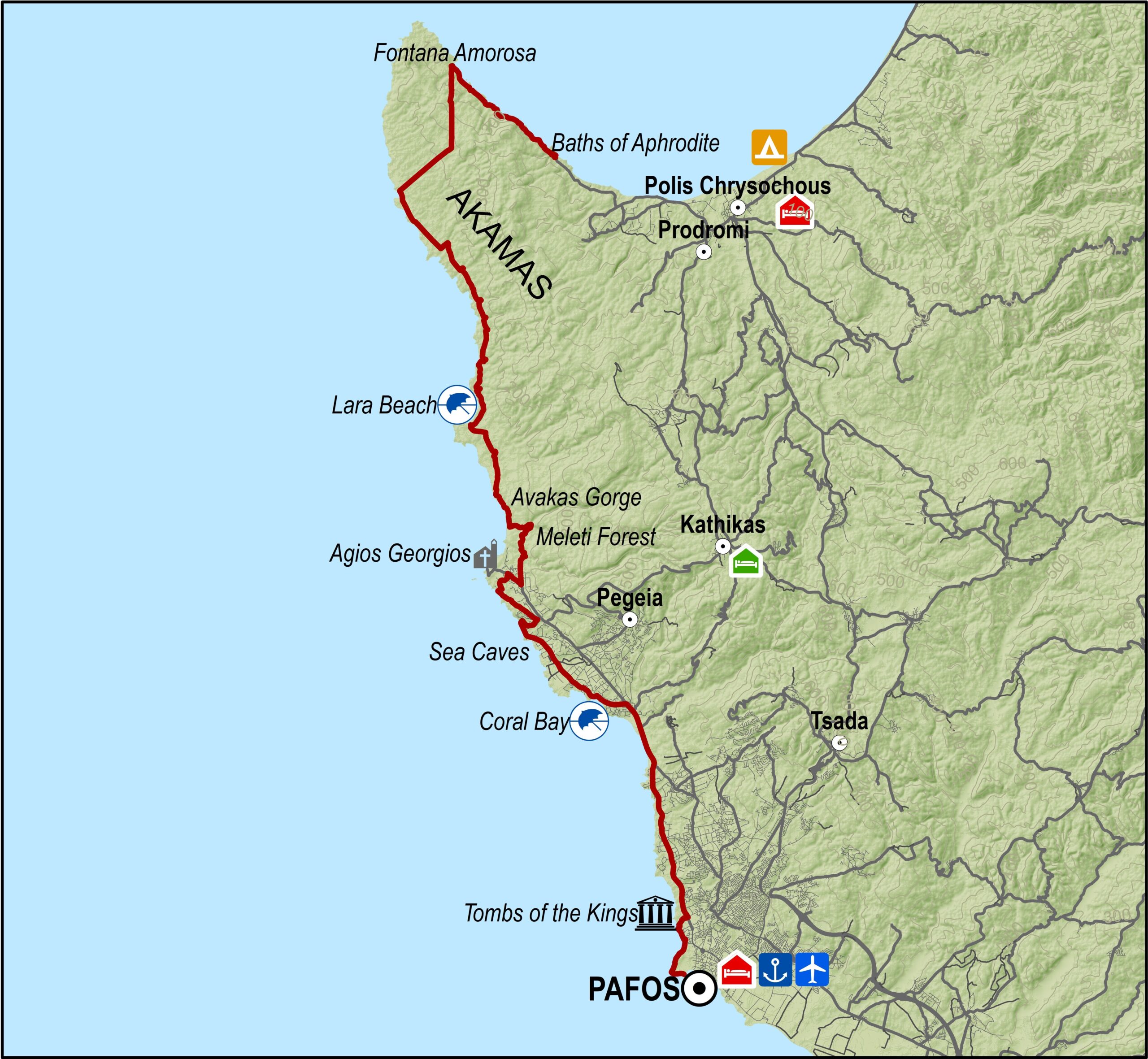
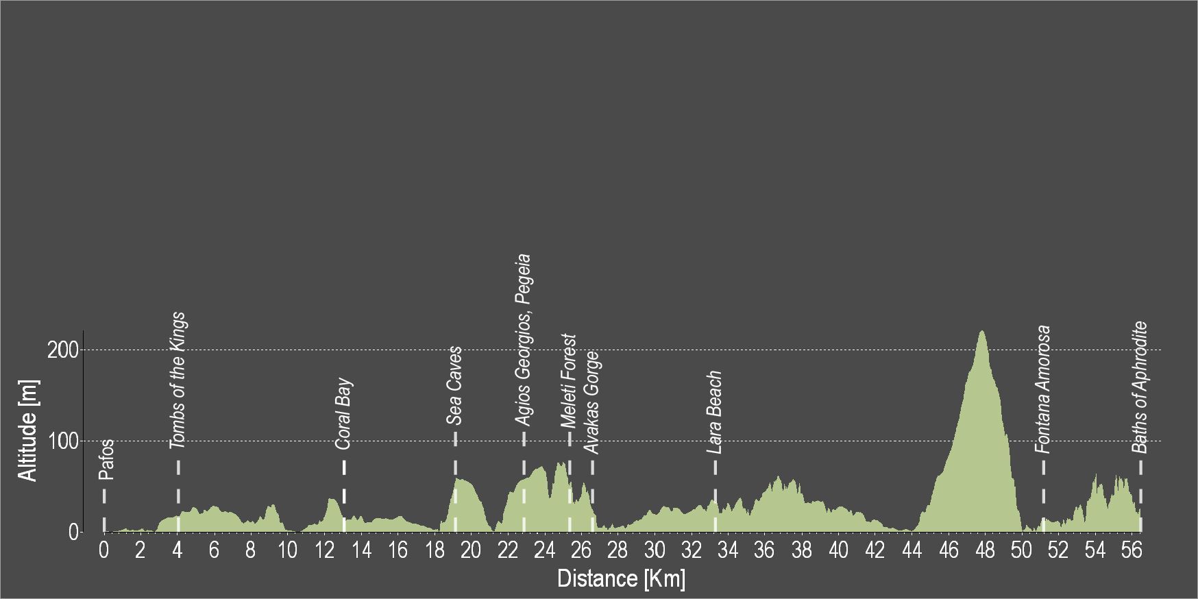
The route explores the west coast of the island. Starting at the Pafos Archaeological Park and passing through the ‘Tombs of the Kings’, two of the most important archaeological sites on the island, you arrive after about 15 km, at the entrance of the Akamas peninsula. On the way there, you can make a small detour towards the Pegeia Sea Caves, a coastal area of stunning natural beauty. When you reach Akamas, not too far from its entrance you can find a path leading through the wonderful Avakas Gorge. It is worthwhile leaving your bike there for a while (you will need to have a lock with you) and walk the path. The Gorge’s impressive geological features and natural beauty definitely deserve a visit!

Continuing your ride on the route, you will pass by Lara beach, nesting ground of the caretta caretta turtles. The turtles dig nests in the soft golden sand where they lay their eggs, and if you are lucky, you might be able to catch a view of the new born turtles.

The route continues along the coast for several kilometres before climbing up into the peninsula. Arriving at the highest point of the route, you can enjoy the magnificent view of the blue Mediterranean Sea stretching on both sides of Akamas peninsula. Descending, you will reach the ‘Fontana Amosora’ area where you can enjoy a swim in the crystal, clear waters of the ‘Blue Lagoon’, one of the most beautiful beaches on the island.

A few kilometres further, you will reach the end of the route a fresh water spring called Loutra tis Afroditis (Baths of Aphrodite), where, according to legend, the Goddess of Love and Beauty used to take her baths.

To download the route in gpx format click here

Troodos 2 – Troodos – Psilo Dentro – Caledonia falls – Troodos Cycling Route

Starting your ride at the Troodos Square, you will immediately find yourself on quiet dirt roads offering great views of Limassol’s wine villages and the Commandaria wine area. Not too far from the start of the route (at 3km), we recommend you to take a little detour to ride up to the viewpoint of the Persephone walking nature trail, ‘Makria Kontarka’, which offers stunning views of the spread of vineyards and wine villages as far as the Lemesos port to the South.

When you return and continue on the route, you will see on your left a scar on the mountain slope left by the long since closed asbestos mine at Pano Amiantos. The Troodos Geopark Visitor Centre is located at the old Asbestos mine, an area with enormous historical value which now hosts an extraordinary botanical garden with information about the flora of the area, a seed bank of endemic species and also a plethora of evidence for the past mining activity and the community which once flourished there. The Geopark Visitor Centre is situated in the newly restored elementary school of the abandoned asbestos mine. Extensive reforestation works are ongoing in an effort to reverse the nature damage that the mine caused. The Centre’s exhibits highlight the extreme geological importance and uniqueness of the Troodos Mountain range and it is worth a visit.

Continuing along the route you will reach its lowest point and then the area Psilodentro. There, you can take a break to regain strength for the long uphill that follows. At Psilodentro there is a hiking trail which leads to the Kalidonia waterfall. There are signs pointing the way to the waterfall if you feel up to it.

The route then continues uphill to the starting point, at Troodos Square.

To download the route in gpx format click here

Troodos 1 – Troodos – Agios Nikolaos Stegis – Troodos Cycling Route

This route descends from Troodos square to the monastery of Agios Nikolaos tis Stegis and climbs steadily from the chromium quarry on the Troodos – Karvounas road, back to Troodos square.

After the Prodromos crossroads, the route goes along a forest road to Agios Nikolaos. From there the it goes along the paved road from Kakopetria to Karvounas, turns right and then climbs Troodos. After almost 9 kilometers of steep uphill the route goes past the Troodos Geopark Information Center in Amiantos. It then reaches the Troodos – Prodromos road and turns left to return to Troodos square.

Difficulty rate: A very difficult route. It requires a 20-speed road bike in good condition.
Road condition: Paved throughout.

To download the route in gpx format click here

Distance: 37.7km
Elevation Gain: 1635m
Highest point: 1824m
Lowest point: 726m
Loop: YES
Terrain: Mountain
Road surface: Paved
Section Distance (km) Total Distance (km)
Troodos Square 0,0 0,0
Prodromos 8,2 8,2
Ag. Nikolaos tis Stegis 11,6 19,8
Kakopetria 2,6 22,4
Platania 4,5 26,9
Karvounas 2,3 29,2
Pano Amiantos 2,3 31,5
Troodos Square 6,2 37,7

Ammochostos 1 – Agia Napa – Pyrgos Xylofagou Cycling Route

This excursion does the round from Agia Napa to Xylofagou and comes back along the Xylofagou – Agia Napa road.
The route begins at the little harbour of Agia Napa and climbs towards the north until it reaches the traffic lights where it turns left and to the west, going along the bicycle path on the left hand side of the road. It then goes past Makronisos on the dirt road that leads to the Agia Thekla chapel and the fishing shelter by the Potamos Liopetriou.
Heading south it goes round Cape Pyla, until it reaches the Xylofagou Medieval Tower. From there it takes a northern course to reach the outskirts of Xylofagou and turns right and to the east taking the Xylofagou – Agia Napa road back to Agia Napa.

Difficulty rate: An easy route but it requires a 21-speed mountain bike.
Road condition: A combination of paved and unpaved roads.

To download the route in gpx format click here

Distance: 38.1Km
Elevation Gain: 78m
Highest point: 51m
Lowest point: 1m
Loop: YES
Terrain: Flat
Road surface: Mixed
Section Distance (km) Total Distance (km)
Agia Napa 0,0 0,0
Potamos Liopetriou 11,4 11,4
Xylofagou Medieval Tower 4,4 15,8
Xylofagou 2,8 18,6
Liopetri 5,4 24,0
Agia Napa 14,1 38,1

Ποδηλατικές Εκδρομές – European Mediterranean Route EuroVelo 8

Ανακαλύψτε και απολαύστε τη φυσική ομορφιά του νησιού καβάλα σ΄ ένα ποδήλατο, ακολουθώντας τις διαδρομές και εκδρομές που προτείνουμε, οι οποίες έχουν σχεδιαστεί ειδικά για να σας βάλουν «στο σωστό δρόμο» και να σας δείξουν τα εντυπωσιακά τοπία της Κύπρου.

Οι εκδρομές μπορεί να πραγματοποιηθούν είτε, όπως παρουσιάζονται εδώ, είτε μπορούν να προσαρμοστούν στις απαιτήσεις και ενδιαφέροντά σας με τη βοήθεια ενός αδειούχου ταξιδιωτικού πράκτορα. Πατήστε εδώ για περαιτέρω πληροφορίες.

Η Κύπρος είναι επίσης μέλος του συγχρηματοδοτούμενου Σχεδίου ‘Eurovelo 8’, το οποίο αναπτύσσει και προωθεί τα εθνικά, περιφερειακά και διακρατικά πακέτα ποδηλατικού τουρισμού κατά μήκος της διαδρομής ‘European Mediterranean Route EuroVelo 8’, μιας από τις 14 διαδρομές ποδηλασίας στο δίκτυο  ‘EuroVelo’ το οποίο συνδέει 11 συνολικά χώρες.

Τα πιο κάτω πακέτα που ετοιμάστηκαν στα πλαίσια του έργου είναι ενδεικτικά και δίνουν την ευκαιρία σε ποδηλάτες, είτε μεμονωμένα, είτε σε ομάδες, να απολαύσουν τις φυσικές ομορφιές της Κύπρου:

>   Μονοήμερη εκδρομή «θάλασσα και ποδήλατο»
>   Μονοήμερη εκδρομή «πετάλια στο άσπρο των βράχων»
>   Διήμερη εκδρομή «ποδηλατώντας σε μοναστήρια και αρχαιότητες»
>   Τριήμερη εκδρομή «πετάλι από την φύση στην πόλη»
>   Πενθήμερη εκδρομή «ποδηλατικό πανόραμα»

Για περισσότερες πληροφορίες για το Σχέδιο Eurovelo 8, παρακαλείστε όπως επικοινωνείτε με τη Θάλεια Χριστοδουλίδου στο [email protected].

Σας ευχόμαστε καλή ποδηλασία!

Ποδηλατική Διαδρομή Πλατεία Τροόδους – Σταυρός της Ψώκας

Συνδέοντας την περιοχή του Τροόδους με τα βουνά του Κύκκου, αυτή η διαδρομή 55 χιλιομέτρων επιτρέπει και επιπλέον διαδρομές στις βορειο-δυτικές ακτές του νησιού, κατά μήκος της διαδρομής από το Σταυρό της Ψώκας στο χωριό Πύργος ή την Πόλη.

Η διαδρομή αρχίζει από την Πλατεία Τροόδους και ανεβαίνει προς τα δυτικά για περίπου 2,5 χιλιόμετρα, όταν φθάνει σε μια στροφή προς τα αριστερά που οδηγεί στον Όλυμπο. Απ΄ εδώ ακολουθεί κατάβαση προς το χωριό Πρόδρομος. Μετά στρίβει δεξιά προς την περιοχή «Pinewood» και περνά πάνω από το χωριό Πεδουλάς μέχρι το Μοναστήρι του Κύκκου. Σ΄ αυτό το σημείο μπορείτε να σταματήσετε στο εστιατόριο του Κύκκου πριν συνεχίσετε για το χωριό Κάμπος. Μια στροφή στ΄ αριστερά πριν από το χωριό Κάμπος οδηγεί στον Σταυρό της Ψώκας στα δυτικά και 3,5 χιλιόμετρα πιο κάτω, ακόμα μια στροφή στα αριστερά οδηγεί στην Κοιλάδα των Κέδρων. Η διαδρομή συνεχίζει ευθεία για ακόμα 16 χιλιόμετρα μέχρι την επόμενη στροφή προς τα αριστερά, που οδηγεί στον Δασικό Σταθμό του Σταυρού της Ψώκας 3 χιλιόμετρα πιο κάτω. Εδώ υπάρχει ένα εστιατόριο, ένας ξενώνας, ένας χώρος πικ νικ και κατασκήνωση, καθώς και μια περιφραγμένη περιοχή όπου υπάρχουν αγρινά (αυτόχθονες αίγες βουνού).

Difficulty rate: Quite a difficult course. It requires a road bike with low/ easy gear ratios
Road condition: Paved roads throughout.
Route Description: This excursion links the Troodos area with the Kykko mountains and enables further trips to the northwest coast of the island, along the route from Stavros to Pyrgos or Polis.

To download the route in gpx format click here

Distance: 90.34km
Elevation Gain: 4746m
Highest point: 1824m
Lowest point: 185m
Loop: YES
Terrain: Mountain
Road surface: Paved


Section Distance (km) Total Distance (km)
Troodos Square 0,0 0,0
Prodromos 8,2 8,2
Pedoulas 3,4 11,6
Kykkos Monastrery 13,7 25,3
Tsakkistra 9,2 34,5
Kampos 2,4 36,9
Oikos 32,6 69,5
Kalopanagiotis 2,2 71,7
Moutoulas 1,4 73,1
Pedoulas 5,8 78,9
Prodromos 3,4 82,3
Troodos Square 8,2 90,5