Lefkosia 1 – Lefkosia (Nicosia) – Machairas – Lythrodontas – Lefkosia Cycling Route

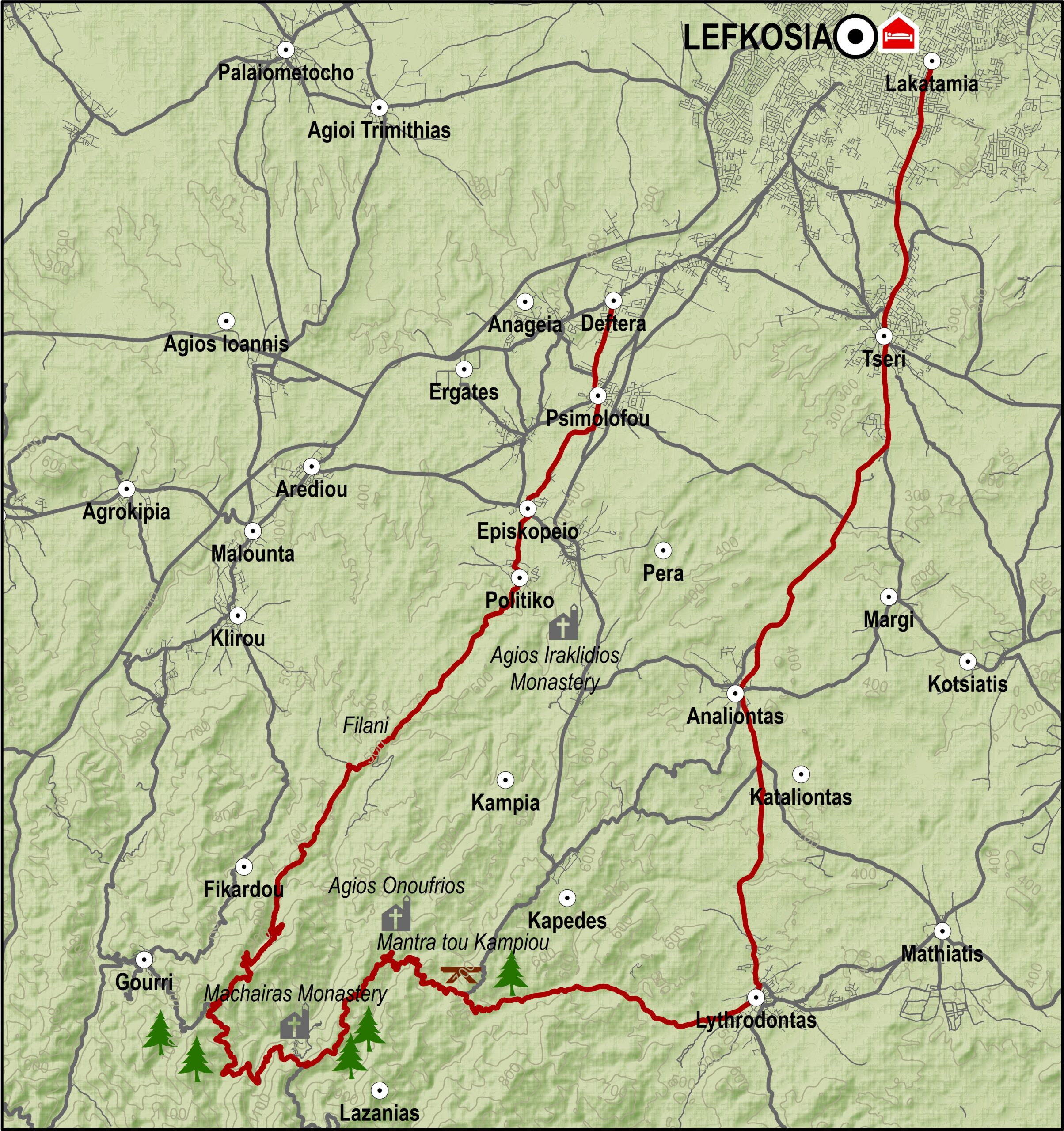
The course starts at Deftera and from there, it goes along the old road to Psimolofou, travelling through agricultural land, to reach the villages of Episkopeio and Politiko, near Agios Irakleidios monastery. From there it heads towards Filani and Machairas. The route from Politiko to Machairas monastery is a steady uphill, while that from Filani to Machairas monastery is a dirt track.

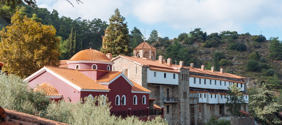
At a distance of 4km outside Politiko the road to the right leads to the village of Lazanias, while that to the left to the Agia Skepi chapel and the Machairas Monastery’s Educational Centre. After a mild ascent for about 3km, it comes across the Machairas quarry, from where a difficult climb begins going all the way up to the monastery. Just before the monastery, is the underground hideout of Gregoris Afxentiou, a Cypriot freedom fighter against the British. The road from here on is paved.

West of the monastery and to the right, is the road that leads to the villages of Lazanias, Gourri and Farmakas and joins up with the Lefkosia (Nicosia) – Pitsylia route. This route continues to the left and east and then once more turns to the north and starts descending. After 6km it goes past the Agios Onoufrios chapel and 3km further on it reaches the picnic site of Mantra tou Kampiou where public toilets and water are available. This is the official site of the 5,5km mountain bike piste of the Cyprus Sunshine Cup, where the international “Afxentia” race is held every year on the last weekend in February.

Past the picnic site, the course heads east on 6km of dirt road towards Lythrodontas. On the outskirts of the village the course turns north towards Analiontas, Tseri and Strovolos. Strovolos avenue leads back to Lefkosia.

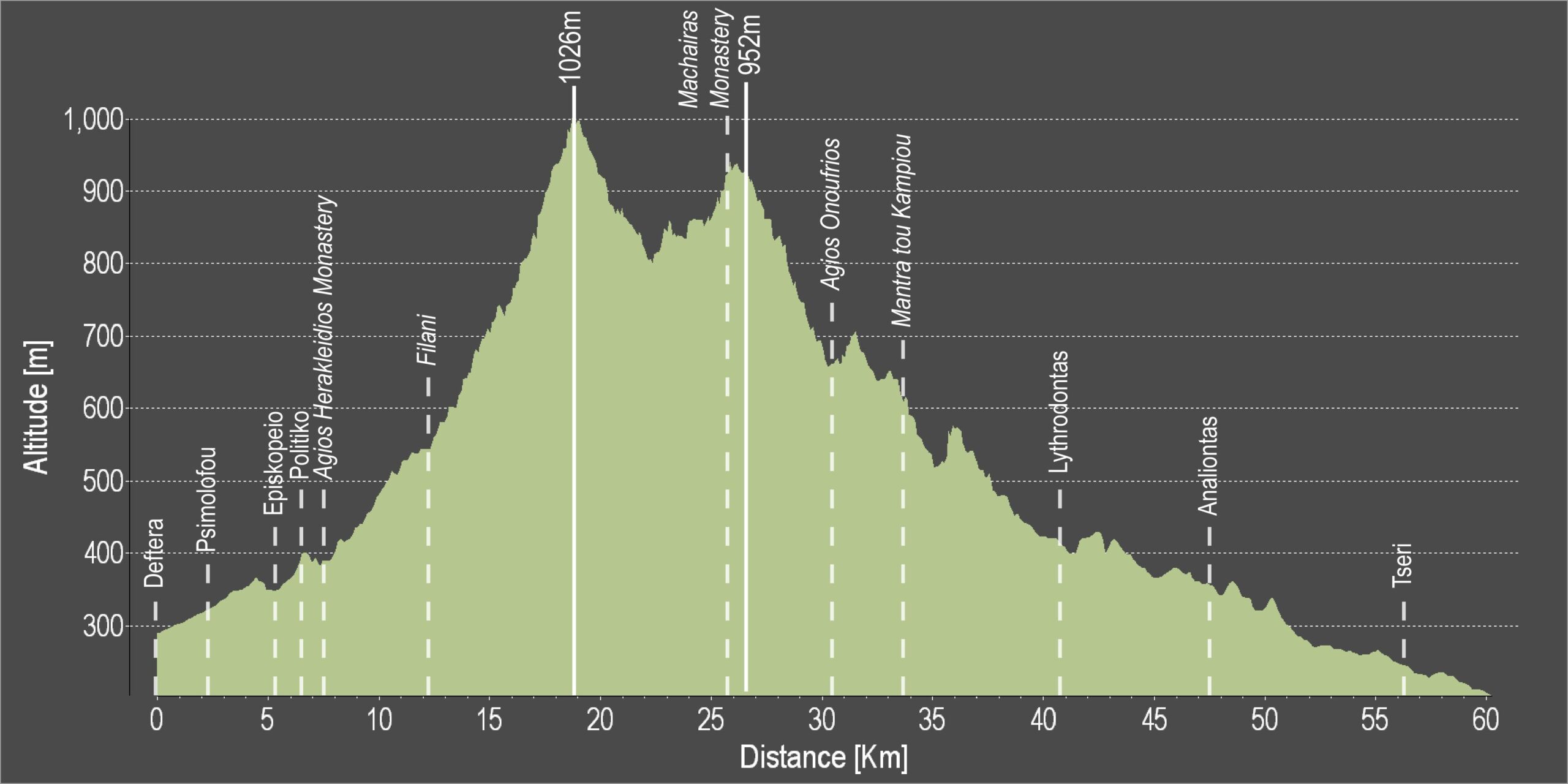
Difficulty rate: A relatively difficult course climbing steadily for about 15km.It requires a mountain bike with a minimum of 27 speeds.
Road condition: A combination of paved and unpaved roads
Route description: Cyclists have the opportunity to visit the Machairas forest, the Machairas monastery, as well as the site where a local hero died in the struggle against British rule, Gregoris Afxentiou .

To download the route in gpx format click here

Distance: 61.6km
Elevation Gain: 1493m
Highest point: 1026m
Lowest point: 205m
Loop: NO
Terrain: Mountain
Road surface: Paved
Section Distance (km) Total Distance (km)
Deftera 0,0 0,0
Psimolofou 2,0 2,0
Episkopeio 3,2 5,2
Politiko 1,2 6,4
Ag. Herakleidios Monastery 0,5 6,9
Filani 5,0 11,9
Machairas Monastery 13,8 25,7
Agios Onoufrios 4,5 30,2
Mantra tou Kampiou 3,2 33,4
Lythrodontas 7,2 40,6
Analiontas 6,7 47,3
Tseri 8,6 55,9
Tseriou St. roundabout 5,7 61,6

Main 3 – Lefkosia (Nicosia) – Solea Valley Cycling Route

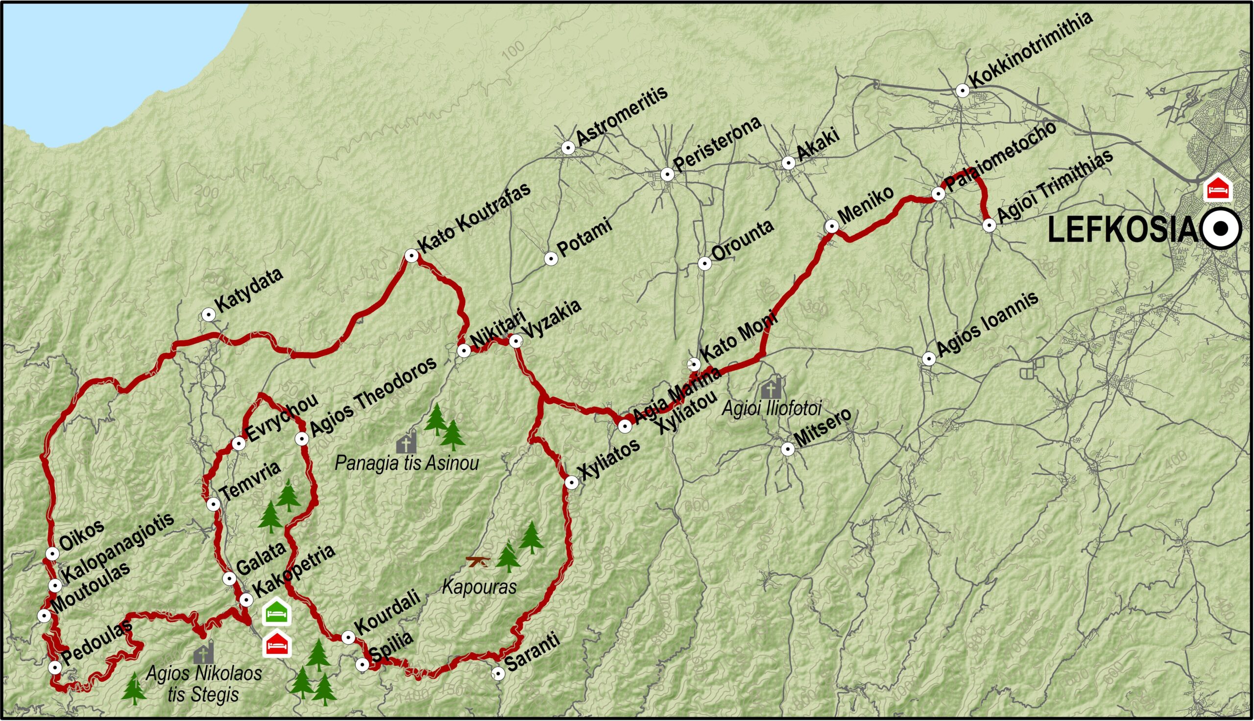
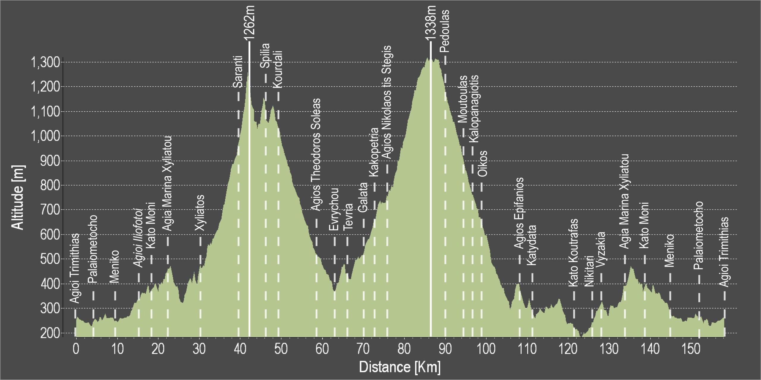
The route starts from Lefkosia (Agioi Trimithias) and follows the road to Agia Marina, passes by the Xyliatos Dam before it reaches the villages of Saranti and Spilia, from where it takes the alternative route towards Agios Theodoros.

At Agios Theodoros the route crosses the main Lefkosia -Troodos road and reaches Kato Flasou where it begins to climb southwards going alongside the Karkotis river, and passing through the villages of Evrychou, Tembria, Kaliana, Galata and Kakopetria.

Keeping on the Kakopetria – Prodromos road, the road starts to climb towards the Agios Nikolaos tis Stegis monastery until it reaches Prodromos where it takes a turning to the right leading to the area Marathasa and the villages of Pedoulas, Moutoullas,Kalopanagiotis and Oikos.

The Pedoulas – Linou road crosses the main Lefkosia-Troodos road and then heads in a northeasterly direction to the village of Koutrafas situated on the banks of the Elia river. The road then climbs towards the villages of Nikitari and Vyzakia, where it follows the same route back to Lefkosia via Agia Marina Xyliatou, Kato Moni, Meniko and Palaiometocho, ending up at the Agioi Trimithias.

An alternative route to the Koutrafas-Nikitari route, is to return to Lefkosia on the main Lefkosia -Troodos road where you can expect more traffic.

Road condition: The route is totally on paved roads.
Route Description: This excursion will take you through the Solea Valley with its traditional architecture and its picturesque Byzantine churches, some of which are on the UNESCO World Heritage List.

To download the route in gpx format click here

Distance: 156.4km
Elevation Gain: 4611m
Highest point: 1338m
Lowest point: 176m
Loop: YES
Terrain: Mountain
Road surface: Paved
Section Distance (km) Total Distance (km)
Agioi Trimithias 0,0 0,0
Palaiometocho 4,0 4,0
Meniko 5,6 9,6
Agioi Iliofotoi 5,5 15,1
Kato Moni 2,5 17,6
Agia Marina Xyliatou 4,5 22,1
Xyliatos 8,0 30,1
Saranti 9,9 40,0
Spilia 6,8 46,8
Kourdali 1,5 48,3
Agios Theodoros Soleas 10,4 58,7
Evrychou 5,1 63,8
Temvria 2,5 66,3
Galata 3,9 70,2
Kakopetria 1,5 71,7
Agios Nikolaos tis Stegis 4,5 76,2
Pedoulas 13,0 89,2
Moutoulas 5,2 94,4
Kalopanagiotis 1,6 96,0
Oikos 2,1 98,1
Agios Epifanios 11,3 109,4
Katydata 1,6 111,0
Kato Koutrafas 10,4 121,4
Nikitari 4,8 126,2
Vyzakia 2,4 128,6
Agia Marina Xyliatou 5,8 134,4
Kato Moni 4,5 138,9
Meniko 8,0 146,9
Palaiometocho 5,6 152,5
Agioi Trimithias 3,9 156,4

Main 1 – Lefkosia (Nicosia) (Deftera) – Pitsylia Cycling Route

This course goes through the beautiful landscape and picturesque villages of the Pitsylia area, famous for its good wine and smoked meat specialities. Although the route is quite long, the section past the village of Alona is mainly descending all the way to Lefkosia.

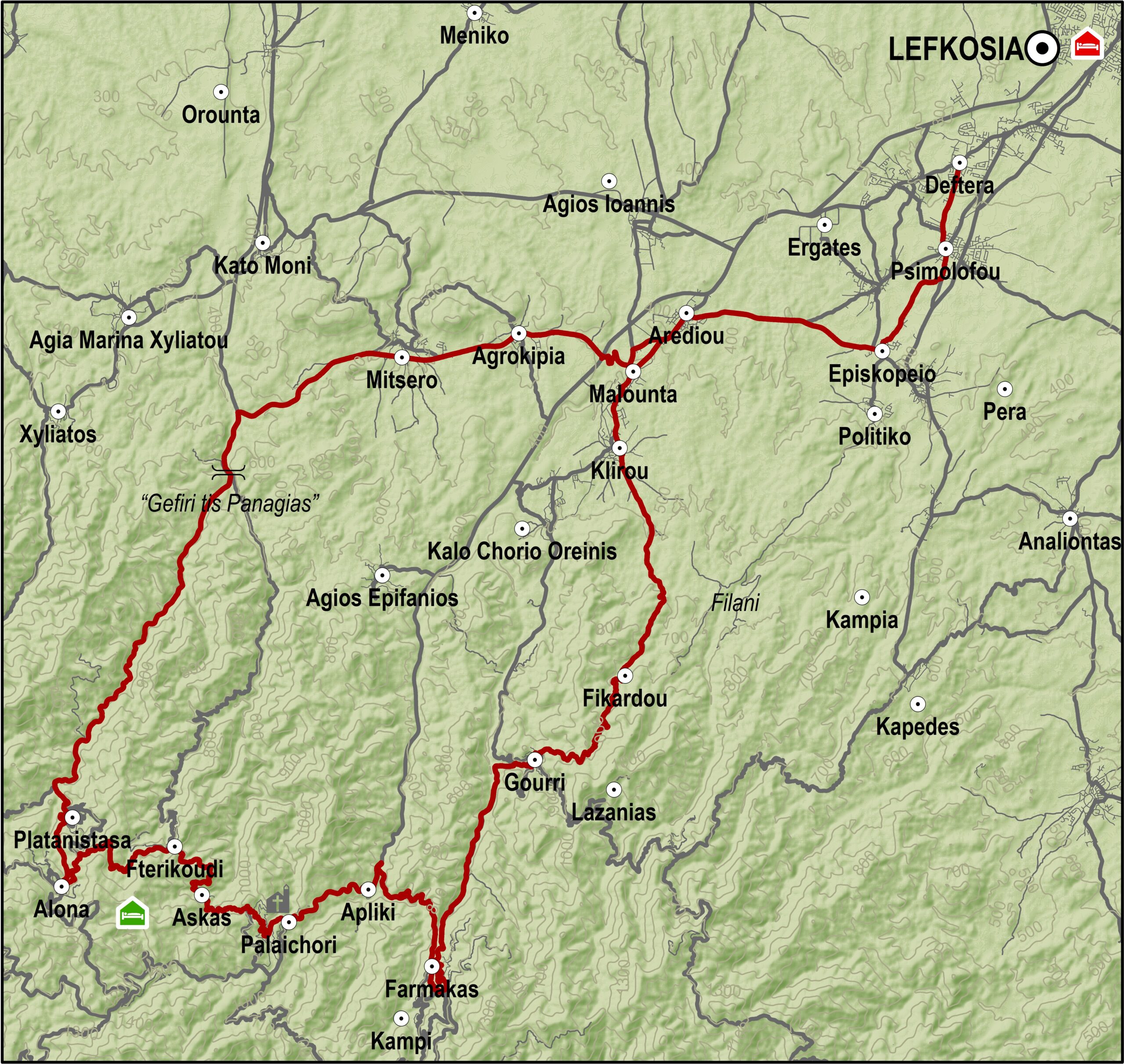
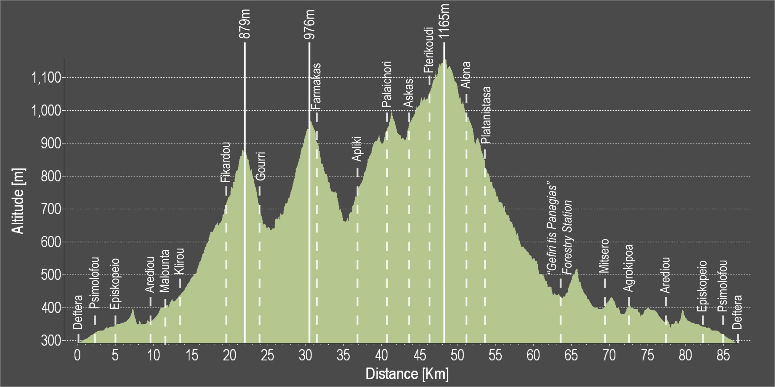
The route follows part of the course from Lefkosia (Deftera) to Machairas up to the village of Episkopeio, but from there it heads west to the village of Arediou instead of the village of Politiko. It gradually climbs from the old Lefkosia-Palaichori road going through Malounta and Klirou and turns left towards Fikardou. From Fikardou it goes downhill to Gourri and then turns right on the road towards Gourri. After you pass through Gourri at the next junction you go left towards the village of Farmakas. From Farmakas the route continues west Apliki. From there it follows the road to Palaichori. From the village of Palaichori after a short climb turns right to take the road for Askas, Fterikoudi and Alona, where it turns right heading north and begins the descent towards Lefkosia. At Alona there is accommodation and restaurants if you wish to spend the night or a few more days in the area. After leaving Alona the course descends towards Platanistasa, passes the “Gefiri tis Panagias” forestry station, arriving at a right turn that leads east to the villages of Mitsero and Agrokipia and ultimately coming out at the Lefkosia-Palaichori road. From there to the left and south, the course reaches the Klirou District Gymnasium, where it turns right just before Arediou to meet the old Lefkosia-Palaichori road heading back to Lefkosia in the opposite direction.

Alternative route: At Gourri, instead of heading towards Lazanias, take the paved road for Farmakas and Palaichori. Turn right and to the north from Palaichori, instead of heading towards Askas-Alona, and start descending to Lefkosia (Deftera).
Difficulty rate: Quite a difficult course even though that the route is descending all the way past the village of Alona. It requires a road bike with low/ easy gear ratios.

To download the route in gpx format click here

Distance: 87.3km
Elevation Gain: 2583m
Highest point: 1165m
Lowest point: 290m
Loop: YES
Terrain: Mountain
Road surface: Paved
Section Distance (km) Total Distance (km)
Deftera 0,0 0,0
Psimolofou 2,1 2,1
Episkopeio 3,0 5,1
Arediou 4,6 9,7
Malounta 1,8 11,5
Klirou 1,9 13,4
Fikardou 6,0 19,4
Gourri 4,5 23,9
Farmakas 7,2 31,1
Apliki 5,9 37,0
Palaichori 3,7 40,7
Askas 2,9 43,6
Fterikoudi 2,6 46,2
Alona 4,8 51,0
Platanistasa 2,4 53,4
“Gefiri tis Panagias” Forestry Station 10,4 63,8
Mitsero 5,7 69,5
Agrokipia 2,8 72,3
Arediou 5,3 77,6
Episkopeio 4,6 82,2
Psimolofou 3,0 85,2
Deftera 2,1 87,3

Main 4 – Lefkosia (Nicosia) – Larnaka (Larnaca) Tourist Beach Cycling Route

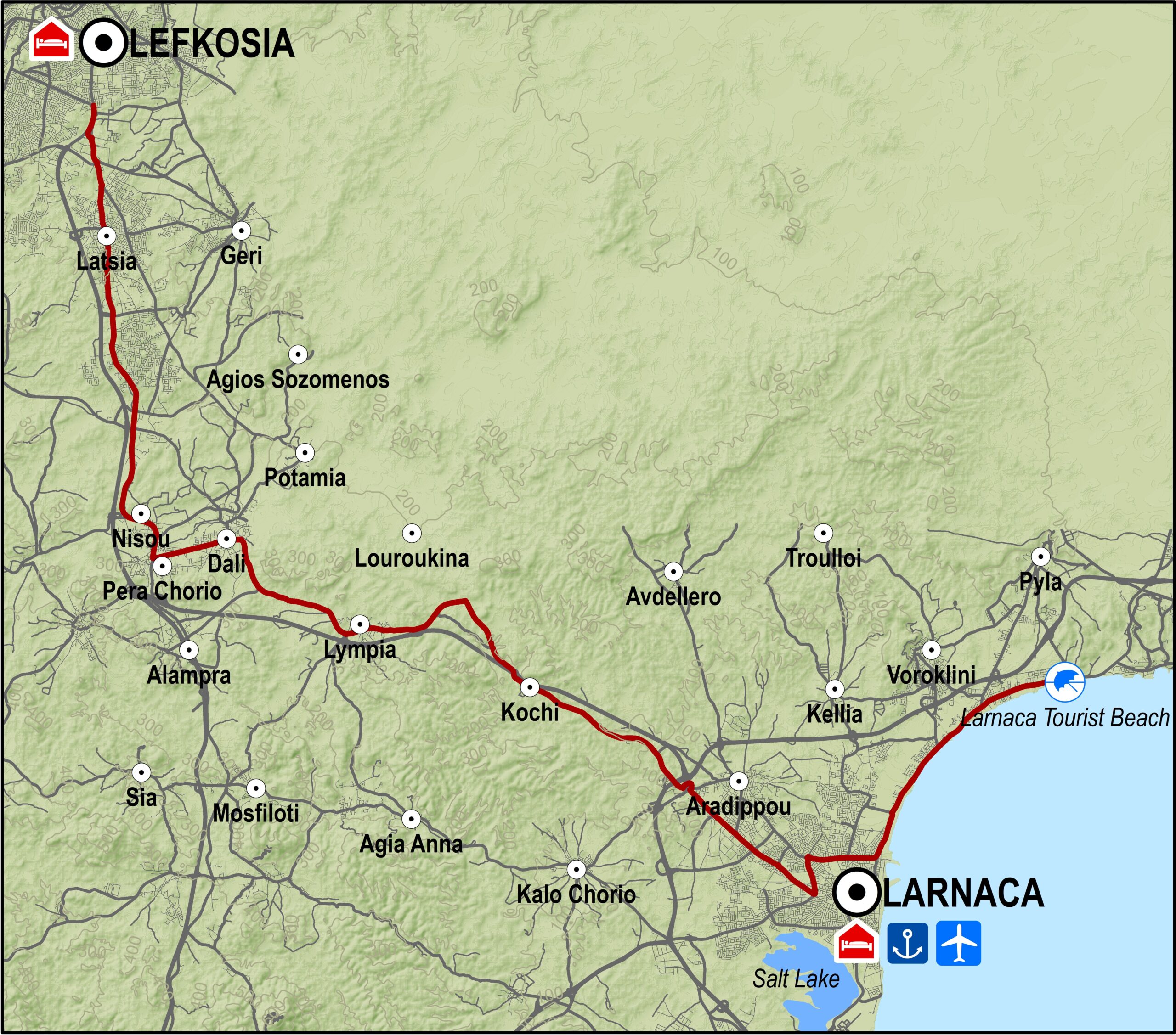
From the traffic lights at the junction of the Lemesos and Athalassa avenues, the route heads south on the motorway to Lemesos and Larnaka. After about 1km, it takes the Lakkia (Latsia) exit on the left, which comes out at the old Lefkosia-Lemesos road. The route then goes through Lakkia (Latsia) and its industrial area, followed by the industrial area of Dali.

At Nisou the route turns to the left heading east towards the small town of Dali. It goes through both Dali and the next village Lympia and then reaches the old Lefkosia-Larnaka road.

From there it turns right heading northeast and travels parallel to the Lefkosia-Larnaka motorway until it reaches Rizoelia on the outskirts of Aradippou. From that point on, the route goes along the motorway next to the Larnaka industrial area and ends up at the Agios Georgios traffic lights. The Fire Department traffic lights are 1km down the road.

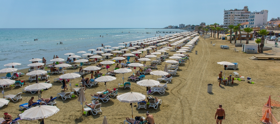
Turning left at the Fire Department traffic lights leads to Stratigou Timagia avenue and the roundabout just outside Larnaka port. The route then enters the tourist area of Livadia, Voroklini and Pyla with its camping site in a small eucalyptus grove. It ends at the Larnaka Tourist Beach a little further down the road, having covered a distance of 53.4km.

Road condition: The entire route is on paved roads.
Route Description: This route is convenient for getting from Lefkosia to Larnaka and the coastal area outside the town. The course travels along the old Lefkosia-Lemesos road until Nisou and then on the old Larnaka-Nisou road.

To download the route in gpx format click here

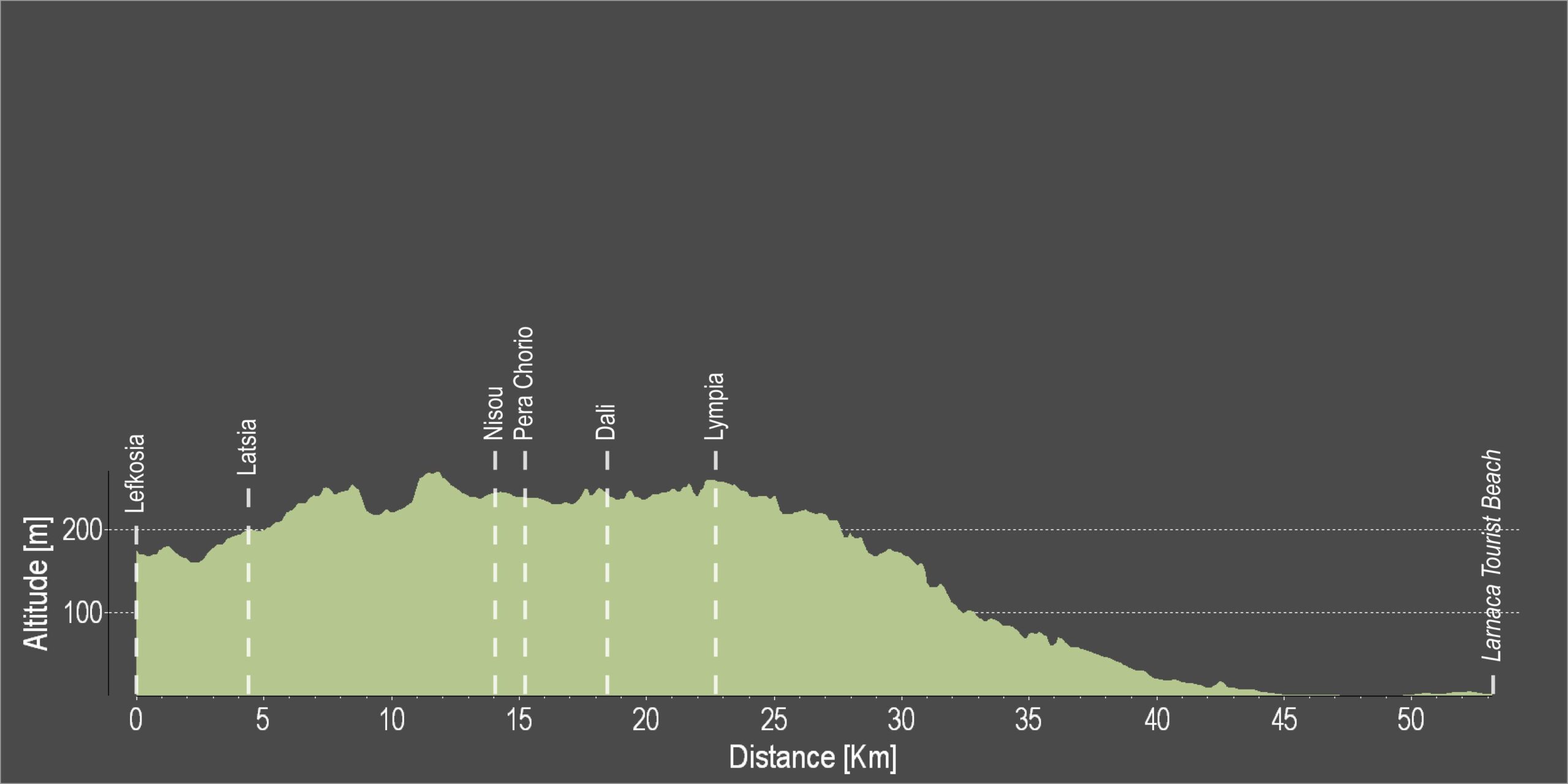
Distance: 53.4km
Elevation Gain: 249m
Highest point: 268m
Lowest point: 1m
Loop: NO
Terrain: Flat
Road surface: Paved
Section Distance (km) Total Distance (km)
Lefkosia 0,0 0,0
Latsia 4,2 4,2
Nisou 9,8 14,0
Pera Chorio 1,1 15,1
Dali 2,4 17,5
Lympia 5,2 22,7
Larnaka Fire Department traffic lights 19,0 41,7
Larnaka Port roundabout 3,3 45,0
Larnaka Tourist Beach 8,4 53,4

Main 5 – Lefkosia (Nicosia) – Lythrodontas – Mosfiloti – Larnaka (Larnaca) Cycling Route

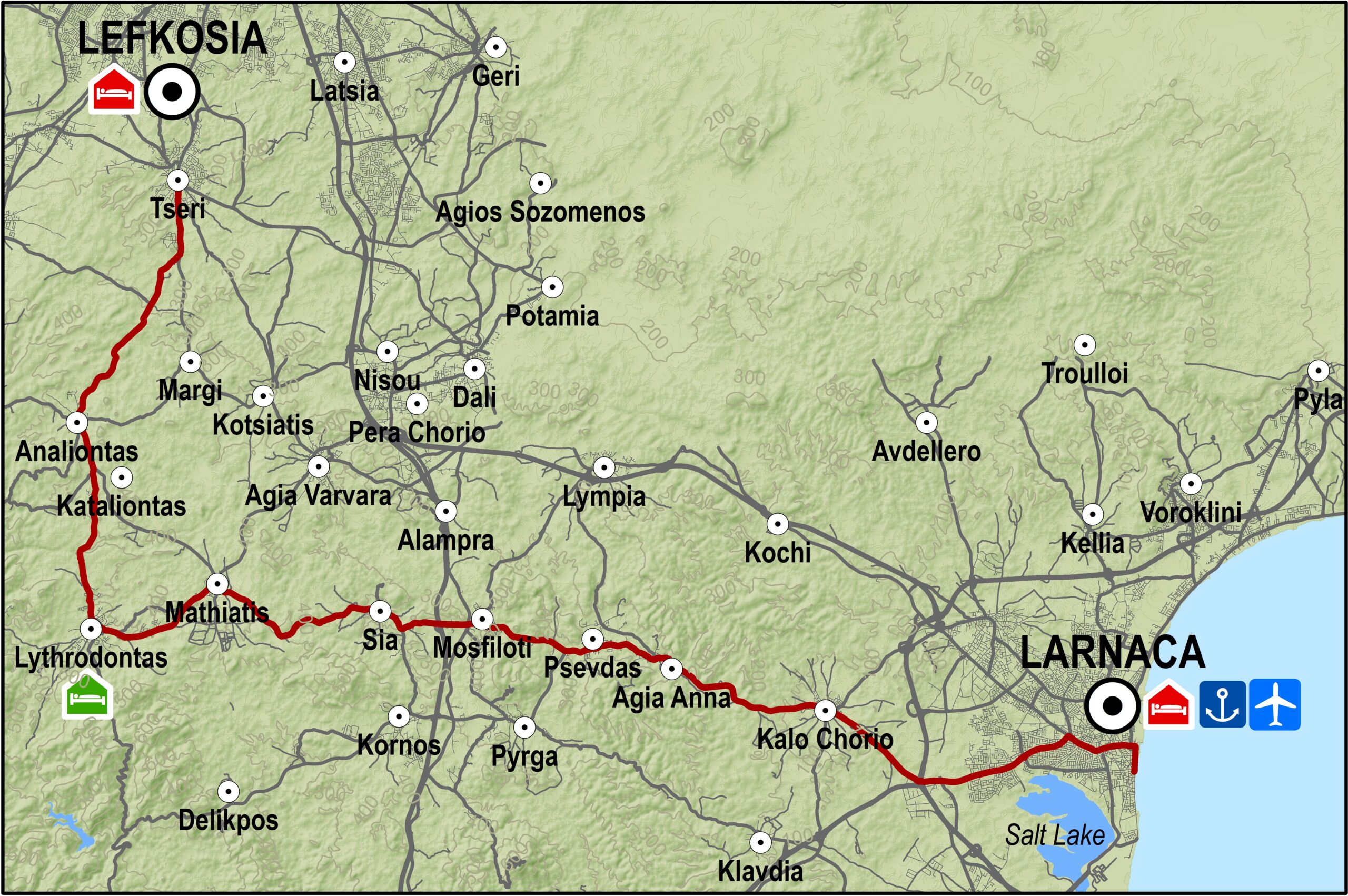
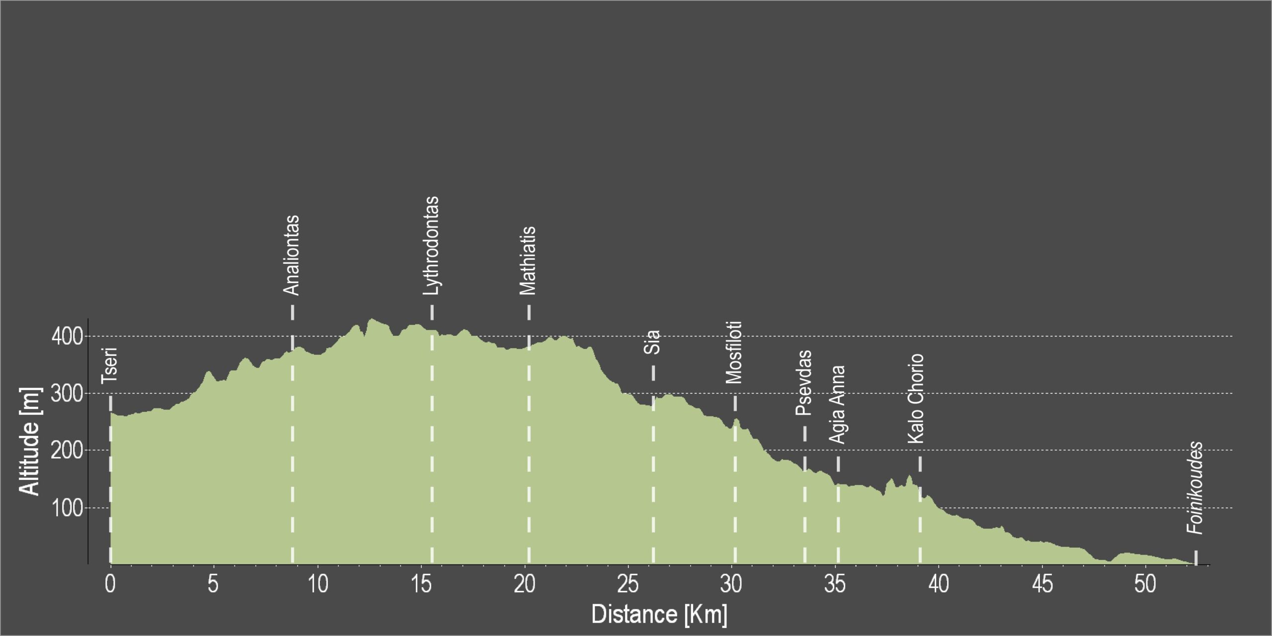
The route begins at the Tseri village and goes through the villages of Tseri, Analiondas and Lythrodontas. It then takes an easterly course through the villages of Mathiatis, Sia, Mosfiloti, Psevdas and Agia Anna until it reaches the Kalo Chorio grade separated junction near the old Larnaka-Kofinou road. There it turns left and to the northwest to reach the Larnaka Fire Department traffic lights and from there the main beachfront of Larnaka city, the Palm tree beach (Foinikoudes).

Route Description: This route is an alternative for going from Larnaka to Lefkosia or vice versa. The monotony of travelling only on paved roads is broken by going through several villages allowing for a little sightseeing and rest.

To download the route in gpx format click here

Distance: 52.1km
Elevation Gain: 368m
Highest point: 430m
Lowest point: 4m
Loop: NO
Terrain: Mixed
Road surface: Paved
  Section Distance (km) Total Distance (km)
Tseri 0,0 0,0
Analiontas 8,7 8,7
Lythrodontas 6,7 15,4
Mathiatis 4,8 20,2
Sia 6,0 26,2
Mosfiloti 3,9 30,1
Psevdas 3,4 33,5
Agia Anna 1,8 35,3
Kalo Chorio 3,8 39,1
Kalo Chorio grade separated junction 3,6 42,7
Larnaka Fire Department traffic lights 4,9 47,6
Foinikoudes 4,5 52,1

Lefkosia 3 – Lefkosia (Nicosia) – Aderfoi Forest – Asinou Cycling Route

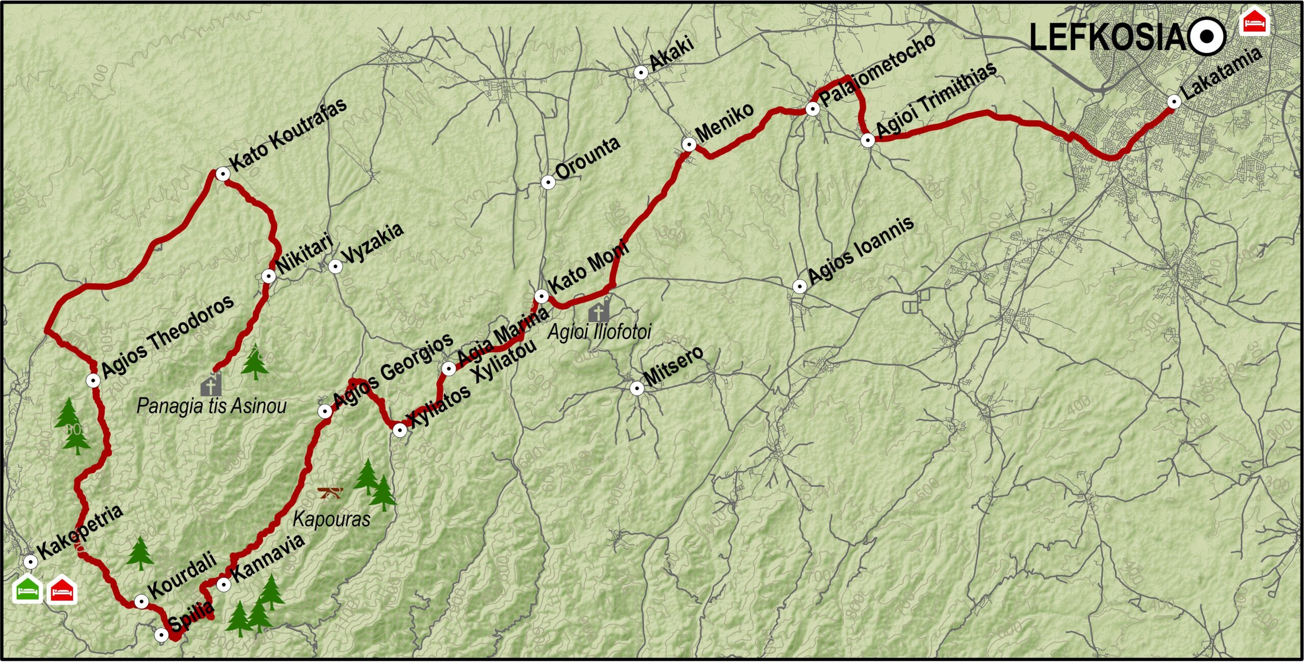
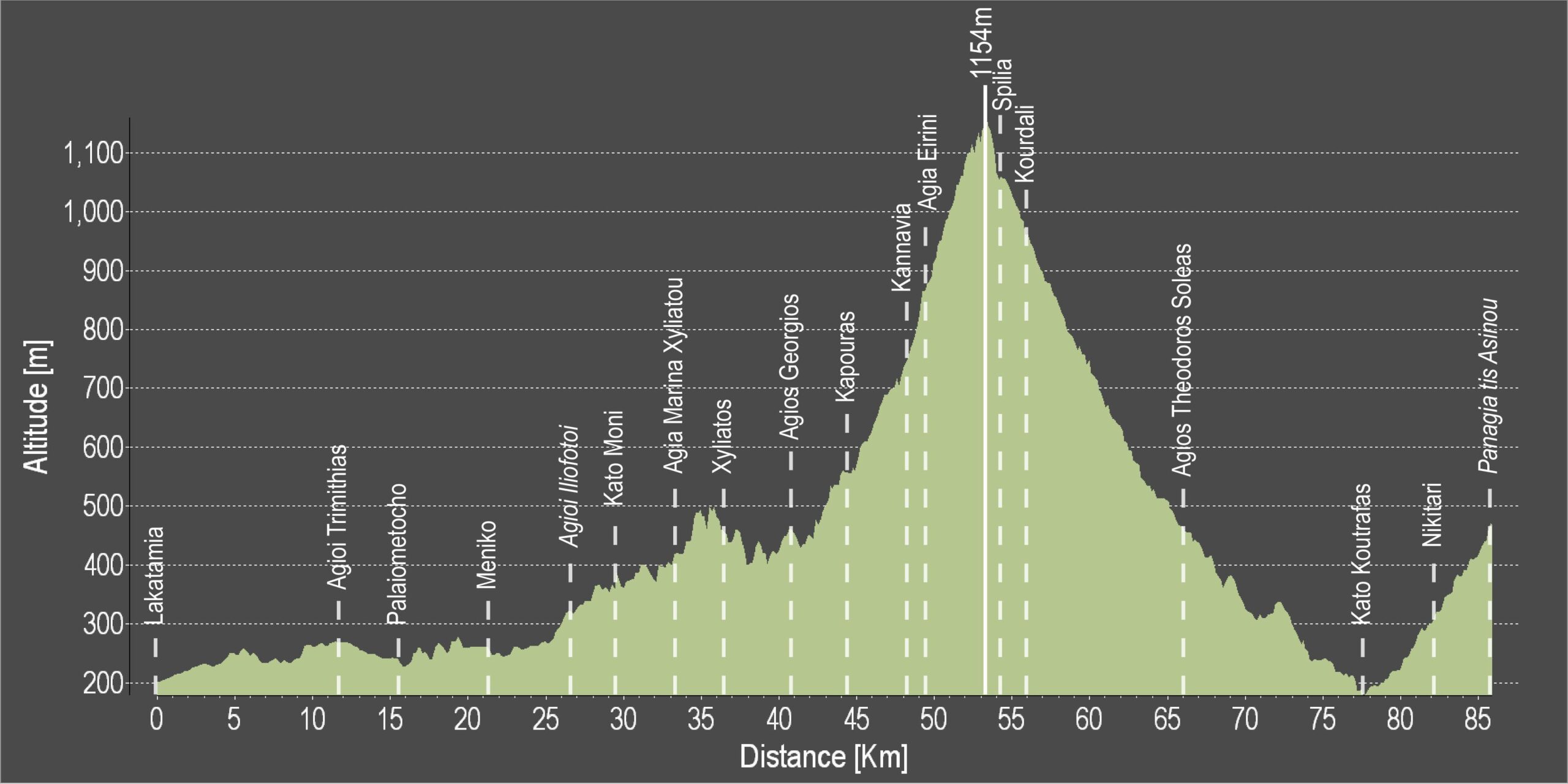
The route’s starting point is the junction on the outskirts of Lakatameia near the “Metro” supermarket. The route heads west for about half a kilometre before it reaches the Lakatameia bicycle path on the banks of the Pediaios riverbed. The bicycle path ends south on Agios Georgios street, where it turns right and west reaching the traffic lights on the Lefkosia-Palaichori road. Almost exactly opposite the traffic lights lies the road that leads to the village of Agioi Trimithias and then towards Palaiometocho and Meniko. From Meniko the route follows the road to the village of Kato Moni. From there Mitsero quarry is visible to the southeast and the Troodos mountains to the southwest.

From Kato Moni the route heads north on the Platanistasa road. It climbs for a short distance then turns right towards the village of Agia Marina. From Agia Marina it passes through the village of Agios Georgios, and past the Kapoura picnic site and the villages of Kannavia and Spilia.

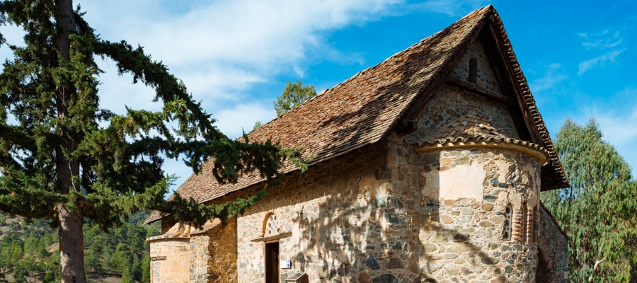
There is a road at the entrance of Spilia and to the right that leads to Agios Theodoros. From there the road takes you to the main road from Troodos to Lefkosia where you head north towards Koutrafas and Nikitari village before you reach Panagia tis Asinou.

Difficulty rate: A difficult course with an average gradient of 2% but not greater than 5%.The course requires road bike with 20 speeds.
Road condition: The entire route is on paved roads.
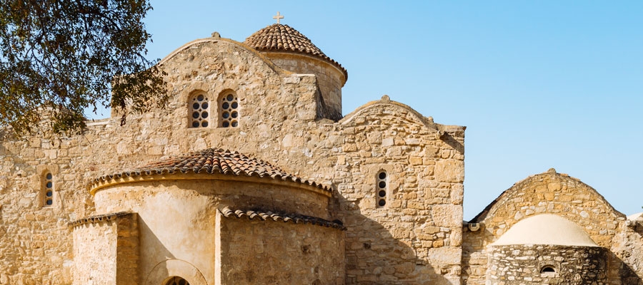
Route Description: This excursion takes cyclists from the outskirts of Lefkosia to the forest of Adelfoi and past the early Byzantine church of Panagia Forviotissa (Asinou).

To download the route in gpx format click here

Distance: 85.9km
Elevation Gain: 2058m
Highest point: 1154m
Lowest point: 176m
Loop: NO
Terrain: Mountain
Road surface: Paved
Section Distance (km) Total Distance (km)
Lakatamia 0,0 0,0
Agioi Trimithias 11,7 11,7
Palaiometocho 3,9 15,6
Meniko 5,6 21,2
Agioi Iliofotoi 5,5 26,7
Kato Moni 2,6 29,3
Agia Marina Xyliatou 3,9 33,2
Xyliatos 3,0 36,2
Agios Georgios 4,6 40,8
Kapouras 3,6 44,4
Kannavia 3,7 48,1
Agia Eirini 1,1 49,2
Spilia 4,8 54,0
Kourdali 1,6 55,6
Agios Theodoros Soleas 10,4 66,0
Kato Koutrafas 11,4 77,4
Nikitari 4,8 82,2
Panagia tis Asinou 3,7 85,9

Lakatamia – Strovolos Cycling Route

The municipalities of Lakatamia and Strovolos have created an 8km bicycle path along the banks of the Pediaios River; from Lakatamia all the way to the Presidential Palace.

Start Point: Lakatamia
End Point: Presidential Palace
Total Distance: 8km
Difficulty Rating: An easy route for all types of bicycle.
Road Conditions: Unpaved but smooth path.
 

Athalassa National Forest Park Cycling Route

Located south of Lefkosia (Nicosia), and to the east of the Lefkosia – Lemesos (Limassol) motorway, the Athalassa National Forest Park has a 16km bicycle path that was created at the initiative of the Forestry Department. It is a popular area for locals who go there for exercise and recreation.

Start Point: South of Lefkosia
End Point: East of the Lefkosia – Lemesos (Limassol) motorway
Total Distance: 16km
Difficulty Rating: An easy route for all types of bicycle.
Road Conditions: Paved road throughout.
 

Byzantine Route: 10 Painted Churches of Troodos Religious Route

Discover the island’s deep religious roots and its significance in the history of Christianity as you follow a path that takes in sacred churches and monasteries, all revered and priceless in their evidence of faith, and humbling to behold.

A genuine Byzantine treasure trove is nestled in the mountain range of Troodos, and reveals the island’s religious heritage through Holy buildings that have remained largely unchanged for centuries. With the island situated at crucial crossroads of the Eastern Mediterranean, the land is characterised by one of the greatest concentrations of churches and grandiose monasteries of the former Byzantine Empire.

With 10 of these beautifully painted churches included on the UNESCO World Heritage List, days out can be spent driving through the areas of Pitsilia, Solea and Marathasa to uncover the stories of their origins, which are as fascinating as the structures themselves. Unique steep-pitched timber roofs shelter chunky wooden doors that open up onto an array of vivid icons and frescos depicting saints, Apostles and stories from the Bible in all their colourful glory.

The sequence of churches dedicated to the Holy Cross is particularly significant. They pay tribute to Agia Eleni, Mother of Constantine the Great, who passed through Cyprus when returning from the Holy Land and was integral in paving the path of Christianity on the island.

PITSILIA
1.   Stavros tou Agiasmati
2.   Metamorfosis tou Sotiro
3.   Timios Stavros
4.   Panagia tou Araka

SOLEA
5.   Agios Nikolaos tis Stegis
6.   Panagia Podithou
7.   Panagia Asinou

MARATHASA
8.   Agios Ioannis Lambadistis
9.   Panagia tou Moutoulla
10. Archangelos Michael


Cyprus of Apostles Pavlos and Varnavas Religious Route

This route follows the steps of Apostles Pavlos and Varnavas starting as follows:

Larnaka (Larnaca) – Kiti – Amathounta – Kourio – Pafos (Paphos) – Agios  Georgios  Pegeias – Salamina – Pegeia then Larnaka, ­ Pegeia, Stavrovouni – Omodos and Larnaka – Tsada.

This route is related to a significant part of the religious history of Cyprus since the passage of these two apostles from Cyprus formed one of the most significant historical facts of the island.

The route gives visitors the opportunity to visit significant churches such as that of Agios Lazaros in Larnaka, Panagia Aggeloktisti in Kiti, old­-Christian basilicas in Amathounta, Kourion and Pafos as well as the great stele where, according to tradition, Apostolos Pavlos was tied and whipped 40 times minus one. At the same time, in the course of this route, visitors will have the opportunity to also visit many ancient buildings which were connected to the Apostles.

Monuments: Monastery of Agios Lazaros in Larnaka, Church of Aggeloktisti in Kiti, Old–Christian basilicas in Amathounta, Kourio, Pafos and Pegeia.

This tour has different parts, therefore its total length varies.