Kofinou – Larnaka (Larnaca) Cycling Route

This 25km route links the village of Kofinou to Larnaka (Larnaca), and vice versa.

Starting from the village of Kofinou – which is often the start or end of a number of routes – it heads northeast. It travels along the outskirts of the villages of Menogia and Anglisides, passes through the village of Alethriko, reaches the grade­separated junction at Kalo Chorio, and ends at the Fire Department traffic lights in Larnaka town.

Start Point: Kofinou
End Point: Fire Department traffic lights
Total Distance: 25km
Height Gain: 5m
Difficulty Rating: An easy route. Ideal for all types of bicycles with speeds.
Road Conditions: Good quality, paved road throughout.
 

Tour of Deryneia Cycling Route

This 85km route is lengthy ­ but not difficult ­ and passes through some of the most popular beaches of Cyprus as it travels along the coast before returning to Larnaka (Larnaca) via the ‘red soil’ villages (Kokkinochoria) of the Ammochostos (Famagusta) area.

The route begins at Larnaka Tourist Beach and heads east along the coastal road. It turns right at the roundabout just outside the British Sovereign Base Area of Dekeleia, and enters the base. It turns right again at the next roundabout, passes the Dekeleia Power Station and travels along the outskirts of the village of Ormideia. It then turns right again, climbing a little as it passes outside the village of Xylofagou. Heading towards Agia Napa, the route goes past the fishing shelter of Potamos Liopetriou and then Makronissos before travelling along the main Agia Napa ­ Paralimni road.

Thereafter, it turns right on to the road for Cape Gkreko, along a bicycle path on the right­hand side of the road (the side nearest the sea).The turning to Cape Gkreko is 4km down the road to the right. Turning north from Cape Gkreko, the route goes past the Agios Anargyros picnic site and the Konnos area until it reaches Protaras. From Protaras, the route continues to the village of Agia Triada where it turns left towards Paralimni. It then cuts across Paralimni and reaches the road leading to Deryneia after turning right and heading north. From Deryneia the route heads back to Larnaka via the potato­growing villages of Frenaros and Liopetri. After Xylofagou, it follows the same route back.

Start Point: Larnaka Tourist Beach
End Point: Larnaka Tourist Beach
Total Distance: 85km
Height Gain: 260m
Difficulty Rating: An easy route. Requires a street bicycle with speeds.
Road Conditions: Good quality, paved road throughout.
 

Agia Napa – Pyrgos Xylofagou Cycling Route

This 32km route takes the cyclist on a loop from Agia Napa to Xylofagou village, returning along the Xylofagou – Agia Napa road. The route begins at the little harbour of Agia Napa, climbing towards the north, until it reaches the traffic lights where it turns left and to the west, along the bicycle path on the left­hand side of the road. It then continues past Makronissos on the dirt road that leads to the chapel at Agia Thekla and the fishing shelter by Potamos Liopetriou. Heading south, it rounds Cape Pylato the Xylofagou Medieval Tower. From there it takes a northern course to reach the outskirts of Xylofagou, then turns right and to the east on to the Xylofagou – Agia Napa road back to Agia Napa.

Start Point: Agia Napa
End Point: Agia Napa
Total Distance: 32km
Difficulty Rating: An easy route. Requires a 21­-speed mountain bike.
Road Conditions: A variety of surfaces.


Lythrodontas Circular Cycling Route

This 45km route offers some of the most beautiful views that the Machairas Mountains have to offer towards Larnaka (Larnaca) Bay and the Mesaoria plains, with Lefkosia (Nicosia) at the centre, and the Pentadaktylos Mountains in the distance.

The route starts from the central square of the village of Lythrodontas and heads left towards Kyprovasa just outside the village on the road to Machairas, passing through olive groves typical of the area. From Kyprovasa, the course turns to the west towards Profitis Ilias. At the junction ­ with the road leading to Profitis Ilias ­ the route continues to the left, heading south towards Vavatsinia. It is worth stopping here to quench your thirst at the Petris water fountain. After a steady 6km climb, the route reaches the paved Lefkara – Vavatsinia road.

The village of Vavatsinia itself is situated a short distance away to the right. Once inside the village, and after turning right for Machairas, the steep paved road becomes a dirt road. It goes past the Moutti of Pelekanou peak and continues on a relatively flat bit of road until it reaches the Kionia picnic site. After Kionia, the road is downhill for about 10km and leads to the chapel of Agios Onoufrios. From there, the road heads back to Lythrodontas via the picnic site of Mantra tou Kampiou ­ at first paved, but then becoming a dirt track.

Start Point: Lythrodontas
End Point: Lythrodontas
Total Distance: 45km
Height Gain: 890m
Difficulty Rating: A very difficult course with steep uphills and sudden, lengthy descents. Requires a mountain bike with 24 speeds and a front fork suspension.
Road Conditions: A variety of surfaces, with a major part of the route on rough, dirt tracks.


Lefkosia (Nicosia) – Solea Valley Cycling Route

This 165km route passes through the Solea Valley with its traditional architecture and its picturesque Byzantine churches, some of which are on the UNESCO World Heritage List.

The tour follows the same route as that of the Lefkosia (Nicosia) ­ – Adelphoi – Asinou route until it reaches the Kapouras picnic site, from where it takes the alternative route towards Asinou and Agios Theodoros. At Agios Theodoros, the route crosses the main Lefkosia – Troodos road to reach Kato Flasou, where it begins to climb southwards, along the Karkotis riverbank, and through the villages of Evrychou, Tembria, Kaliana, Galata and Kakopetria.

Keeping on the Kakopetria – Prodromos road, the road starts to climb towards the Agios Nikolaos tis Stegis Monastery until it reaches a turning to the right leading to the area of Stavroulia. This part of the road is unpaved and descends in a northerly direction to the Linou – Pedoulas road, offering breathtaking views of Solea Valley and Morfou Bay to the east.

The Pedoulas – Linou road crosses the main Lefkosia – Troodos road and then heads in a north­easterly direction to the village of Koutrafas, situated on the banks of the Elia River. The road then climbs towards the villages of Nikitari and Vyzakia, where it follows the same route back to Lefkosia via Orounta, Kato Moni, Meniko and Palaiometocho, ending at the Agios Mamas grade­ separated junction.

An alternative route to the Koutrafas – Nikitari option is to return to Lefkosia on the main Lefkosia – Troodos road.

Start Point: Agios Mamas grade separated junction
End Point: Agios Mamas grade separated junction
Total Distance: 165km
Difficulty Rating: A difficult route climbing steadily at a 2% gradient on average, and maximum 5%. Requires a mountain bike with at least 21 speeds.
Road Conditions: A variety of surfaces.


Lefkosia (Nicosia) – Pitsylia Cycling Route

This 115km route passes through the beautiful landscape and picturesque villages of the Pitsylia area, famous for its good wine and smoked meat specialities. Although the route is quite long, the section past the village of Alona is downhill all the way to Lefkosia (Nicosia).

The route follows part of the Lefkosia – Machairas route, as far as the village of Episkopi. But from there, it heads west to the village of Arediou instead of on to the village of Politiko, climbing gradually on the old Lefkosia – Palaichori road through Malounta and Klirou, and then turning left towards Fikardou. From Fikardou it goes downhill to Gouri, and then turns right on to the road towards Lazanias and Machairas. Just before Lazanias, the route follows the first dirt road to the right, leading to the village of Farmakas. This dirt road is like a parapet above the cliffs and will give adrenaline addicts a real thrill.

From Farmakas, the route continues south to just above Profitis Ilias at Sykopetra. From there, it follows a paved road to the right and heads west to Palaichori. From the village of Palaichori, the route leads to the Lefkosia – Agros road, turns left and after a short climb turns right to take the road for Askas, Fterikoudi and Alona. There it turns right, heading north, and begins the descent towards Lefkosia. At Alona there is accommodation and restaurants if you wish to spend the night or a few more days in the area.

After leaving Alona, the course descends towards Platanistasa, past the ‘Gefiri tis Panagias’ forestry station, to a right turn leading east to the villages of Mitsero and Agrokipia. From there to the left and south, the route reaches Klirou District Gymnasium. There it turns right just before Arediou to meet the old Lefkosia – Palaichori road, heading back to Lefkosia in the opposite direction.

Alternative route: At Gouri, instead of heading towards Lazanias, take the paved road for Farmakas and Palaichori. Turn right and to the north from Palaichori, and instead of heading towards Askas – Alona, start the descent to Lefkosia.

Start Point: Agios Mamas grade­ separated junction
End Point: Agios Mamas grade­ separated junction
Total Distance: 115km
Height Gain: 1.265m
Difficulty Rating: A fairly difficult course, despite the road being downhill all the way past the village of Alona. Requires a mountain bike with at least 21 speeds. A front fork suspension is recommended.
Road Conditions: A variety of surfaces.
 

Lefkosia (Nicosia) – Asinou Cycling Route

This 83km route takes cyclists from the outskirts of Lefkosia (Nicosia) to the forest of Adelfoi, and past the early Byzantine church of Panagia Forviotissa (Asinou).

The route’s starting point is the junction on the outskirts of Lakatamia where it heads west for about half a kilometre before reaching the Lakatamia bicycle path on the banks of the Pediaios River. The bicycle path ends on Agios Georgios Street, where it turns right and west to reach the traffic lights on the Lefkosia – Palaichori road. Almost exactly opposite the traffic lights lies the road that leads to the village of Agioi Trimithias and onto Palaiometocho and Menoiko.

From Menoiko, the route follows a dirt road before reaching the paved road just outside the village of Kato Moni. From there, Mitsero quarry is visible to the southeast, and the Troodos Mountains to the southwest. From Kato Moni, the route heads north on the Peristerona – Platanistasa road. It climbs for a short distance before turning right towards the village of Agia Marina. From Agia Marina it passes through the village of Agios Georgios, and past the Kapoura picnic site and the villages of Kannavia and Spilia. There is a dirt road at the entrance of Spilia ­ and to the right ­ leading to Asinou and the area where the anti­colonial EOKA movement was most active. The dirt road travels north through the Adelfoi forest for 23km, leading to the Byzantine church of Panagia Forviotissa in Asinou. An alternative road for Asinou is the 9km forest road just after the Kapouras picnic site to the west.

Some 3km along a paved road after Asinou is the village of Nikitari. From there, road signs lead back to Lefkosia through the villages of Vyzakia and Orounta. This part of the road is not paved. From Orounta, the route turns north on to the Peristerona – Platanistasa road towards Kato Moni for the return journey to Lefkosia. An alternative, less complicated route is via Orounta and Peristerona and back to Lefkosia along the main Lefkosia – Morfou road.

Start Point: Agios Mamas grade­ separated junction
End Point: Asinou
Total Distance: 83km
Height Gain: 975m
Difficulty Rating: A difficult route with an average gradient of 2%, but not greater than 5%. Requires a mountain bike with 21 speeds.
Road Conditions: A variety of surfaces.


Mountainous Larnaka (Larnaca) – Lefkosia (Nicosia) Wine Route

Comprising the expanse of the mountainous areas of both Larnaka (Larnaca) and Lefkosia (Nicosia), this varied route is one that marries the old viticultural history of the island with the new, modern face of the winemaking industry.

Passing through 10 villages, the route takes in three wineries, quaint museums and workshops. Even though it is outside of the traditional wine regions, there are active winemakers here who have planted vineyards with the white varieties of  Assyrtiko, Malvasia Aromatica, Chardonnay Xynisteri and Sauvignon blanc, and the red varieties of Maratheftiko, Cabernet and Merlot – ensuring their fast integration into the island’s winemaking portfolio.

A love of wine is combined with other cultural aspects along this route, such as the inclusion of the village of Lefkara – famous for its handmade lace embroidered linens and delicate filigree silver – along with the village of Fikardou, which is home to one of the oldest traditional wine presses in Cyprus.

This enlightening route passes through: Lefkosia, Skarinou, Lefkara, Kato Drys, Vavla, Ora, Odou, Farmakas, Gourri, Fikardou and Kalo Chorio.

Pitsilia Wine Route (Routes)

In a region where pines and vines grow freely into the mountainsides, neat villages exude rural charm and produce a range of fine wines that are yours to discover and savour.

A cluster of 11 villages and two of the most well-known wineries (in Pelendri) are included in the ‘Nom d’Origine’ Pitsilia – an area that spreads around the mountain peaks of Madari, Papoutsa, and the north-western part of Machairas. Here, the altitude secures a more slow and effortless grape maturity, whilst the arid and sloping earth forces the vines to huddle together and produce richer wines.

Classic local grape varieties continue to have a dominant presence amongst the vineyards of Pitsilia, with smatterings of the rare and ancient red variety of Maratheftiko. The grapes grown at these highest points are taken to two local winemakers for the production of excellent vintages.

This flourishing route passes through: Lemesos (Limassol), Trimiklini, Pelendri, Potamitissa, Dymes, Kyperounta, Chandria, Polystypos, Alona, Agros, Agios Ioannis and Agios Theodoros.


Commandaria Wine Route

Take a trip back in time and discover the secrets of the island’s most ancient and famous wine – the sweet dessert wine of Commandaria – that has been praised and world-renowned for centuries.

The route through 14 Commandaria villages goes back to 1192 AD when the knights of St. John were perfecting the production of the world’s first named wine. The sweet wine took its identity from the place it was mainly produced –  ‘La Grande Commanderie’  – which is the area now known as Kolossi. So famed was Commandaria that it even won in the first recorded wine tasting competition  – the ‘Battle of the Wines’ – which took place in the 13th century, and was held by the French king Philip Augustus.

Indigenous Mavro (red) and Xynisteri (white) grapes are picked late in the season and dried in the sun to intensify their natural sweet flavours, giving the drink its distinctive taste. The dried grapes are then pressed, with the run-off collected and fermented in tanks or huge earthenware jars – much like those used in bygone times.

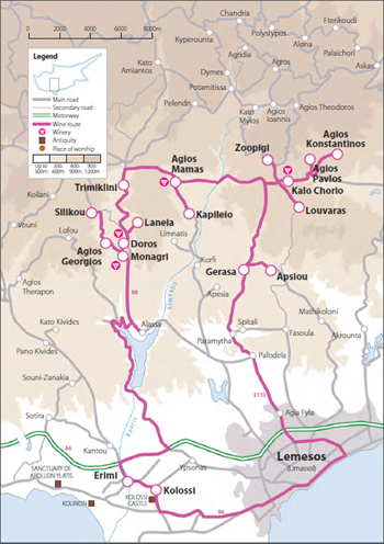
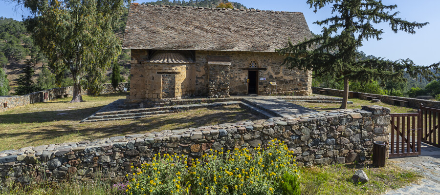
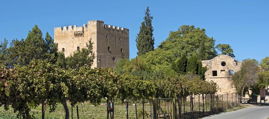
There are four wineries on this route, and a visit to the region is not complete without stopping by the refurbished wine press of Laneia, which has been maintained throughout the centuries, and serves as a reminder of the land’s glorious winemaking past. A further popular site is also the Medieval Castle of Kolossi – or ‘La Grande Commanderie’ as it was once known.

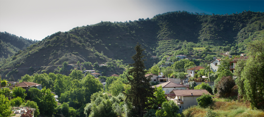
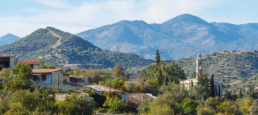
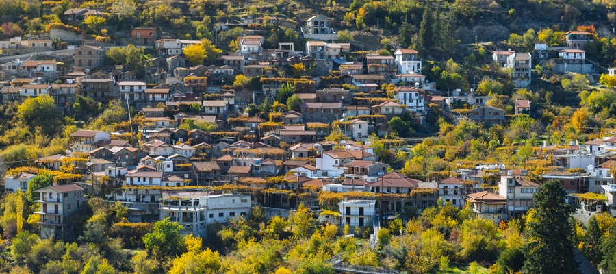
The villages themselves can all be found at an altitude of 500 to 900 metres. Their vines share the landscape with thick, bushy wild growth and sparse woods, whilst the rich flora and fauna are quite impressive – as are the historic and archaeological monuments of the vicinity. The area is also home to the Kouris Dam, the biggest in Cyprus, and an important wetland.

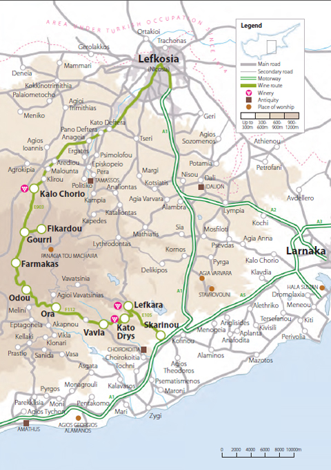
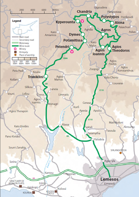
This historic route passes through: Lemesos (Limassol), Kolossi, Erimi, Monagri, Agios Georgios, Silikou, Doros, Laneia, Trimilkini, Agios Mamas, Kapileio, Zoopigi, Kalo Chorio, Agios Pavlos, Agios Konstantinos, Louvaras, Gerasa and Apsiou.