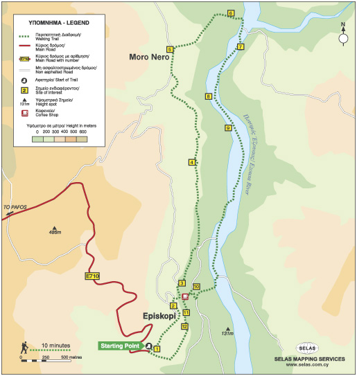
Ezousa Walking Trail (Circular), Pafos (Paphos) District Nature Trail

GPS coordinates of the starting point: Lat: 34.791653 Lon: 32.523179
GPS coordinates of the ending point: Lat: 34.791653 Lon: 32.523179
Altitude of the starting point: 247m
Altitude of the highest peak: 247m
Altitude of the end peak: 247m
Starting point: Environmental Information Centre of Episkopi, Pafos (Paphos).
Length: 7.6km
Estimated duration: 3 hours
Difficulty rate: 2 (downhill and uphill gradient around Ezousa Valley)


Points of interest: The Environmental Information Centre houses exhibition areas with scenes and exhibits, as well as showing documentaries about the natural environment and biodiversity of the surrounding area.

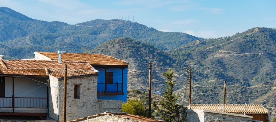
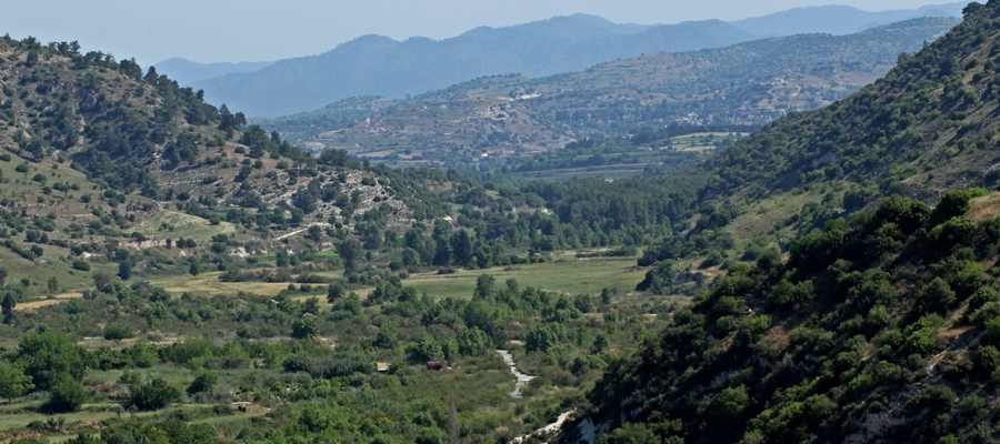
There are excellent views along the way but the most impressive view is from the “Rock” on which the village church, devoted Saint Ilarion the Great, is built. Here, you can enjoy uninterrupted views of the Ezousa Valley below as well as taking in the beauty of nature itself. From this particular point, visibility extends to the Pafos forest and the mountain range of Troodos. The trail crosses over the Ezousa Valley at a certain point with lush growth, especially Oriental Plane Tree and Oriental Alder which offer shade to travelers on hot summer days, making the walk a unique and pleasant experience.

Flora: While walking you can study these indigenous plants: Cyprus cyclamen (Cyclamen cyprium), Bosea (Bosea cypria), Oleander (Nerium oleander), Oriental alder (Alnus orientalis), Oriental plane tree (Platanus orientalis), Oak tree (Quercus infectoria), Locust tree (Ceratonia siliqua), Terebinths (Pistacia Terebinthus), Kermes oak (Quercus coccifera), Spiny broom (Calicotome villosa).

Ecclesiastical Museum – Sotira village

Located in the chapel of Saint George in Sotira village, the Ecclesiastical Museum exhibits important religious treasures, such as sacred icons (including one of Jesus Christ from the 15th century), old forms Gospels, liturgical books, crosses, liturgical vessels and others artefacts. It also houses one of only three portable wooden altars of the 16th century that exist in Cyprus.

Next to the museum is the church of Metamorphosis tou Sotiros (Transfiguration of the Saviour). This stone-built, single-aisle, vaulted church was built above the foundations of an earlier Byzantine basilica temple.

The village itself was significant during Byzantine times, which is reflected in the number of old churches there are in the vicinity of the village.

Region: Ammochostos (Famagusta)
Address: Sotira village
Contact No: Tel: +357 23 823 932
Operating Hours: By appointment.
Operating Period: All year round.
Closed on Public Holidays.
Entrance Fee: Free (donations accepted)
Website: www.sotira.org.cy
  Opening and closing times as well as entrance fees, are subject to alterations without notice. Visitors are advised to check before visiting.


Cultural Centre of Famagusta (Ammochostos) Municipality

The Cultural Centre of Occupied Ammochostos (Famagusta) was created to host regular presentations and briefings regarding the prevailing ‘Cyprus Problem’ – the resulting division of the island following the Turkish invasion of 1974.

Binoculars are available for viewing the occupied city of Ammochostos, and there is also a small photographic exhibition.

Region: Ammochostos
Address: Evagorou, 35, Deryneia village
Contact No: Tel: +357 23 740 860, Fax: +357 23 740 861
Operating Hours: Summer opening hours (8.5 – 1.11):
Monday ­ Friday: 07:30 ­-17:00
Saturday: 07:30-15:00 

Winter operning hours (4.11 – 5.5):
Monday  – Saturday: 07:30 ­-15:00
During these hours the Cultural Center is open to the public.  For organized and guided tours, you can call +357 23740860 or send an email to [email protected]

Operating Period: All year round
Closed on Public Holidays
Entrance Fee: Free
Disabled Access: Wheelchair accessible
Website: www.famagusta.org.cy
  Opening and closing times as well as entrance fees, are subject to alterations without notice. Visitors are advised to check before visiting.
 

Ancient Idalion Archaeological Site

The archaeological site of Idalion, in the Dali Village area, is one of the most important sites in Cyprus, with many of its rich findings now exhibited in some of the most renown museums of the world.

The ancient city was founded by the Achaean hero of the Trojan war, Chalcanor – descendant of Teucer, the founder of Salamis. According to legend, Ancient Idalion is where Adonis – Aphrodite’s lover – was killed by her jealous lover Aris, the Olympian God of War.

The kingdom flourished until the middle of the 5th century BC, when its capital was besieged and captured by the Phoenician kings of Kition. Finds have been unearthed from both settlements and cemeteries in the region, with the earliest remains of human occupation found at the locality of Agridi, dating back to the 7th and 5th centuries BC.

The site houses a museum and Visitor Centre, which showcase its finds, and is also linked with the Aphrodite Cultural Route.

Region: Lefkosia (Nicosia)
Address: Dali village
Contact No: Tel: +357 22 444 818
Operating Hours: Monday – Friday: 08:30 – 16:00
Closed on weekends.
Operating Period: All year round.
Closed on Public Holidays.
Entrance Fee: €2,50
For organised groups consisting of more than 10 persons there is a 20% reduction on the entry fees.
The Department of Antiquities can issue special entry cards for all its museums and ancient monuments: One (1) day entry cards – €8,50, three (3) day entry cards – €17,00, seven (7) day entry cards – €25,00.
Disabled Access: Wheelchair accessible.
Website: www.mcw.gov.cy/da
  Opening and closing times as well as entrance fees, are subject to alterations without notice. Visitors are advised to check before visiting.
 

European Mediterranean Route EuroVelo 8

Discover and enjoy the natural beauty of the island from the pedal of a bike with our suggested itineraries, all created to put you on the ‘right track’ and showcase Cyprus’ stunning landscape.

Cyprus is also part of the cofunded project ‘MedCycleTour’, which is based on the ‘European Mediterranean Route – EuroVelo 8’, one of the 15 long distance cycle routes in the network ‘EuroVelo’ that connects 11 countries. ‘MedCycleTour’ aims to develop cycle tourism in the Mediterranean region by providing transnational tools to attract visitors. The project is cofunded by the Interreg Mediterranean Programme, the project has a budget of over €2,5 million.

The MedCycleRoute project will contribute to the development of the EuroVelo 8 – Mediterranean Route by exchanging good practices; surveying the existing cycle route; developing regional and transnational action plans; preparing and publishing promotional material related to EuroVelo 8; and implementing pilot projects such as signposting, promotional tools (web sites, apps, etc.) and cycle friendly schemes.

Lead by the Andalusian Government – Agency of Public Works, Andalusian Ministry of Development and Housing (Spain) -, the project has 10 other partners from 7 countries, besides the Deputy Ministry of Tourism. The European Cyclists´ Federation (Belgium), Alpes Maritimes (France), Catalonia Region (Spain), Western Greece (Greece), Friuli Venezia Giulia Region (Italy), Province of Mantova (Italy), Regional Development Center of Koper (Slovenia), Croatian National Tourism Board (Croatia) and the Cluster for Eco-Social Innovation and Development (Croatia).

For more information about EuroVelo please visit: www.eurovelo.com

For more information about EuroVelo 8 please visit: www.eurovelo8.com

For more information about MedCycleTour project please visit: https://medcycletour.interreg-med.eu/ or please contact Thalia Christodoulidou at [email protected].

Happy cycling!

Vasilikos Maroni Panorama

The route starts from the village of Kalavasos with a slight uphill ascent towards the village of Asgata. Pass through the narrow streets of the village and continue uphill to Vasa, Sanida and then to Kellaki. Woodland areas and unique views will be encountered along the way. Ride downhill to reach the Eptagoneia Village and the small picturesque village of Akapnou. Continue towards Ora, Lageia, Vavla and ride further downhill to Choirokoitia. Pass through the village of the picturesque and beautiful Tochni to reach the starting point in Kalavasos.

To download the route in gpx format click here

Distance: 57.6km
Elevation Gain: 1169m
Highest point: 724m
Lowest point: 65m
Loop: YES
Terrain: Mountain
Road surface: Paved
Section Distance (km) Total Distance (km)
Kalavasos 0,0 0,0
Asgada 6.6 6.6
Vasa 5.1 11.7
Sanida 3.6 15.3
Kellaki 4.1 19.4
Eptagonia 4.5 23.9
Akapnou 3.0 26.9
Ora 3.5 30.4
Lageia 6.3 36.7
Vavla 2.4 39.1
Choirokoitia 9.7 48.8
Choirokoitia Neolithic Settlement 0.0 48.8
Tochni 2.8 51.6
Kalavasos 6.0 57.6

Vasilikos Maroni Panorama Intense

The route starts from the village of Kalavasos with a slight uphill ascent towards the village of Asgata. Pass through the narrow streets of the village and continue uphill to Vasa, Sanida and then to Kellaki. Woodland areas and unique views will be encountered along the way. Ride downhill to reach the Eptagoneia Village and the small picturesque village of Akapnou. Continue towards Ora, Lageia, Vavla and then ride uphill to Kato Drys village. A big downhill ride will follow which leads to the village of Skarinou. Pass through the village and continue to Choirokoitia and then to beautiful Tochni. Continue straight ahead to reach the starting point of the route in Kalavasos.

To download the route in gpx format click here

Distance: 67.3km
Elevation Gain: 1484m
Highest point: 724m
Lowest point: 65m
Loop: YES
Terrain: Mountain
Road surface: Paved
Section Distance (km) Total Distance (km)
Kalavasos 0.0 0.0
Asgada 6.6 6.6
Vasa 5.1 11.7
Sanida 3.6 15.3
Kellaki 4.1 19.4
Eptagoneia 4.5 23.9
Akapnou 3.0 26.9
Ora 3.5 30.4
Lageia 6.3 36.7
Vavla 2.4 39.1
Agios Minas Monastery 2.4 41.5
Kato Drys 3.1 44.6
Skarinou 9.0 53.6
Choirokoitia 4.1 57.7
Choirokoitia Neolithic Settlement 0.0 57.7
Tochni 2.7 60.4
Kalavasos 6.9 67.3

Ancient Vasilikos Extended

The route starts at the Governor’s Beach heading west to Monagroulli. A three kilometre uphill ride will lead to the beautiful village of Asgata. Pass through the narrow streets of the village and go downward to Kalavasos. The paved traditional streets, the grand church of the Virgin Mary and the Mosque are some of the many things to admire in Kalavasos. Then, head south and discover the village of Tochni where the ancient church of the village is bound to impress. The village of Choirokoitia is next, where the Neolithic Settlement of Choirokoitia is located, which has been listed as a UNESCO World Heritage Site since 1998. Skarinou and Agios Theodoros are the villages to follow before reaching Zygi and the Zygi Marina. Continue towards Vasiliko to finish the circular route at Governor’s Beach.

To download the route in gpx format click here

Distance: 60.2km
Elevation Gain: 806m
Highest point: 336m
Lowest point: 3m
Loop: YES
Terrain: Mixed
Road surface: Paved
Section Distance (km) Total Distance (km)
Governor’s Beach 0.0 0.0
Monagrouli 8.5 8.5
Asgada 5.1 13.6
Kalavasos 6.7 20.3
Tochni 6.1 26.4
Choirokoitia 3.0 29.4
Choirokoitia Neolithic Settlement 0.0 29.4
Skarinou 3.1 32.5
Agios Theodoros 5.3 37.8
Zygi 12.4 50.2
Governor’s Beach 10.0 60.2

Ancient Vasilikos

The route starts at the Governor’s Beach and heads westward to Monagroulli. A three kilometre uphill ride will lead to the beautiful village of Asgata. Pass  through the narrow streets of the village and go downward to Kalavasos. The paved traditional streets, the grand church of the Virgin Mary and the Mosque are some of the many things to admire in Kalavasos. Then, head south and discover the village of Tochni where the ancient church of the village is bound to impress. Choirokoitia and Psematismenos are the villages to follow before reaching Zygi and the Zygi Marina. Continue towards Vasiliko to finish the circular route at Governor’s Beach.

To download the route in gpx format click here

Distance: 47.2km
Elevation Gain: 677m
Highest point: 338m
Lowest point: 3m
Loop: YES
Terrain: Mixed
Road surface: Paved
Section Distance (km) Total Distance (km)
Governor’s Beach 0,0 0,0
Monagroulli 8.5 8.5
Asgada 5.1 13.6
Kalavasos 6.7 20.3
Tochni 6.1 26.4
Choirokoitia 3.0 29.4
Choirokoitia Neollithic Settlement 0.0 29.4
Psematismenos 3.3 32.7
Zygi 4.5 37.2
Governor’s Beach 10.0 47.2

Divine Coast

The route starts from Governor’s Beach and heads towards the coast and westward towards Lemesos. Cross Lemesos by going along the entire coastline of the city, from the Molos area, to the old port, to Limassol Marina, etc. Continue west and pass through the archaeological site of Kourion where the ancient theatre of Kourion is located. Ride uphill to the Sanctuary of Apollon Hylates and continue to reach the Episkopi and the Happy Valley. Pass through the Paramali village and end the route in Pissouri and Pissouri Bay.

To download the route in gpx format click here

Distance: 131.2km
Elevation Gain: 1191m
Highest point: 241m
Lowest point: 2m
Loop: YES
Terrain: Mixed
Road surface: Paved
Section Distance (km) Total Distance (km)
Governor’s Beach 0,0 0,0
Ancient Amathus 10.5 10.5
Dasoudi Beach 9.5 20.0
Old Port 4.3 24.3
Limassol Marina 0.6 24.9
asomatos 8.2 33.1
Ancient Kourion 9.5 42.6
Episkopi 4.9 47.5
Paramali 5.6 53.1
Pissouri Bay 10.5 63.6
Pissouri 3.3 66.9
Paramali 11.5 78.4
Episkopi 5.5 83.9
Ancient Kourion 5 88.9
Kolossi Castle 5.5 94.4
Trachoni 4.6 99
Limassol Marina 7.2 106.2
Old Port 0.6 106.8
Dasoudi Beach 4.3 111.1
Ancient Amathus 10.5 121.6
Governor’s Beach 9.6 131.2