Trooditissa – Foini (Linear) – Lemesos (Limassol) District, Troodos Forest Nature Trail

GPS coordinates of the starting point: Lat: 34.912177 Lon: 32.837174
GPS coordinates of the ending point: Lat: 34.896838 Lon: 32.837357
Altitude of the starting point: 1,330m
Altitude of the highest peak: 1,330m
Altitude of the end peak: 944m
Starting point: The Platres – Prodromos main road.
Length: 4.5km
Estimated duration: 2 hours
Difficulty rate: 1


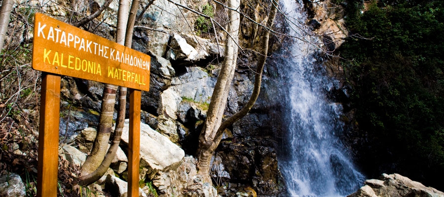
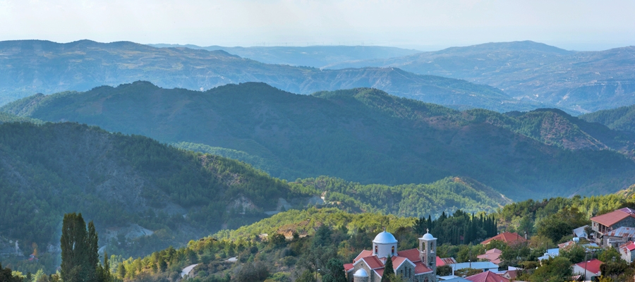
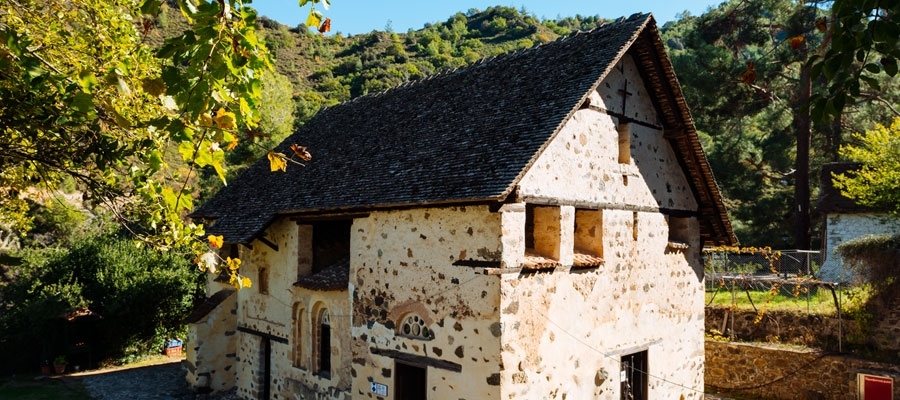
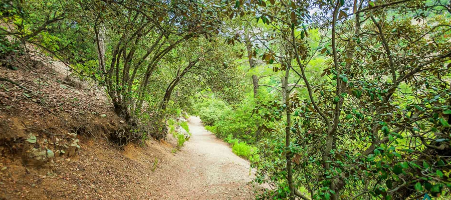
Points of interest: The route follows a forest road that connects Trooditissa Monastery with the beautiful village of Foini, with exceptional views towards the village along the way. The trail crosses the Trooditissa River and leads you to the route’s main attraction, the Chantara waterfall (eight metres high), then passes by vertical cliffs before the journey ends on the Foini – Agios Dimitrios road, right outside Foini. The entire trail is located within Troodos National Forest Park, which is a Natura 2000 area.

Flora: While hiking you can study (amongst other plants) the indigenous plants: Calabrian pine (Pinus brutia), strawberry tree (Arbutus adrachnae), and the endemic golden oak (Quercus alnifolia).


Psilondentro (Tall Tree) – Pouziaris (Circular) ­- Lemesos (Limassol) District, Troodos Forest Nature Trail

GPS coordinates of the starting point: Lat: 34.895957 Lon: 32.869154
GPS coordinates of the ending point: Lat: 34.920633 Lon: 32.881826
Altitude of the starting point: 1,178m
Altitude of the highest peak: 1,718m
Altitude of the end peak: 1,178m
Starting point: The crossing point of the forest road Platres – Mesa Potamos with the tourist road Moniatis – Platres – Troodos, close to the Psilodentro (Tall Tree).
Length: 9km
Estimated duration: 3 – 4 hours
Difficulty rate: 3 (very challenging due to the uphill and downhill areas of the route)


Points of interest: For the first kilometre, the path passes through dense clusters of Calabrian pine trees, whilst on the third kilometre at the points with a higher altitude it passes through an impressive and dense black pine forest (Pinus nigra subsp.pallasiana). At points along the trail you will experience panoramic views. The path is located within the National Forest Park of Troodos.

Flora: While hiking you can study the endemic plants: Golden oak (Quercus alnifolia), Purple Rock Cress (Arabis purpurea), Manouthkia (Pterocephalus multiflorus subsp. multiflorus – an evergreen small shrub with pale pink flowers), Cyprus Skullcap (Scutellaria cypria subsp. cypria), Troodos Sage (Salvia willeana).

Fauna: The main species of fauna found in the area are:

Mammals: Fox, hare, hedgehog.

Birds: Bonelli’s eagle, Eurasian jay, Wood pigeon, partridge, Cyprus warbler (endemic), Cyprus wheatear (endemic).

Reptiles: Cyprus viper, Cyprus snake (endemic), Cyprus lizard.

Kalidonia (Linear) – Lemesos (Limassol) District, Troodos Forest Nature Trail

GPS coordinates of the starting point: Lat: 34.914670 Lon: 32.870569
GPS coordinates of the ending point: Lat: 34.895785 Lon: 32.868541
Altitude of the starting point: 1,571m
Altitude of the highest peak: 1,571m
Altitude of the end peak: 1,238m
Starting point: (a) 350m from the main road of Troodos Square ­ Platres, 3km from the square. You can also access the starting point from the old Troodos ­ Platres road, after the Presidential Summer Residence
(b) At the Psilodentro (Tall Tree) above Pano (Upper) Platres.
Length: 3km
Estimated duration: 1.5 hour
Difficulty rate: 3


Points of interest: From the starting point (a) the trail passes through a dense forest and then runs alongside the Cold River (Krios Potamos), which has running water all year round. It then passes by the Kalidonia Waterfall and finishes at the Psilodentro in Pano Platres. The trail is located within the Troodos National Forest Park. In Troodos Square you will find the Environmental Information Centre for the Troodos National Forest Park.

Flora: While hiking you can study the endemic plants: Troodos sage (Salvia willeana), Purple Rock ­ Cress (Arabis purpurea), Thorny gorse (Genista fasselata subsp. crudelis), Urse mint (Mentha longifolia subsp. cyprica), Aphrodite’s spurge (Euphorbia veneris), Golden oak (Quercus alnifolia).

Fauna: The main species of fauna found in the area are:

Mammals: Fox, hare, hedgehog.

Birds: Bonelli’s eagle, Eurasian jay, Wood pigeon, partridge, Cyprus warbler (endemic), Cyprus wheatear (endemic).

Reptiles: Cyprus viper, Cyprus snake (endemic).

Persephone (Linear) – Lemesos (Limassol) District, Troodos Forest Nature Trail

GPS coordinates of the starting point: Lat: 34.920443 Lon: 32.881202
GPS coordinates of the ending point: Lat: 34.908118 Lon: 32.903485
Altitude of the starting point: 1,733m
Altitude of the highest peak: 1,733m
Altitude of the end peak: 1,654m
Starting point: 150m south of Troodos Square, in the direction of the police station.
Length: 3km
Estimated duration: 1 hour
Difficulty rate: 1


Points of interest: The trail is located within the Troodos National Forest Park, and for the first two kilometres of the route, you will pass through dense black pine forest. The ending point at Makria Kontarka offers stunning views. The Kampos tou Livadiou picnic area is located two kilometres from Troodos Square ­ in the direction of Karvounas ­ and at a distance of 2.5 kilometres, you will find the ‘Armyrolivado’ and ‘Livadi tou Pasia’ picnic sites. The Environmental Information Centre for the Troodos National Forest Park can be found in Troodos Square.

Flora: While hiking you can study the endemic plants: Golden oak (Quercus alnifolia), Cyprus Skullcap (Scutellaria cypria subsp. cypria), Troodos catmint (Nepeta troodi), Cyprus Germander (Teucrium cyprium subsp. cyprium), Manouthkia (Pterocephalus multiflorus subsp. multiflorus – an evergreen small shrub with pale pink flowers), Troodos sage (Salvia willeana).

Fauna: The main species of fauna found in the area are:

Mammals: Fox, hare, hedgehog.

Birds: Bonelli’s eagle, Eurasian jay, Wood pigeon, Partridge, Cyprus warbler (endemic), Cyprus wheatear (endemic).

Reptiles: Cyprus viper, Cyprus snake (endemic).

Artemis (Circular) – Lemesos (Limassol) District, Troodos Forest Nature Trail

GPS coordinates of the starting point: Lat: 34.933166 Lon: 32.871986
GPS coordinates of the ending point: Lat: 34.933221 Lon: 32.871964
Altitude of the starting point: 1,835m
Altitude of the highest peak: 1,850m
Altitude of the end peak: 1,835m
Starting point: 300m from where the Chionistra road meets the Troodos – Prodromos road.
Length: 7km
Estimated duration: 2.5 – 3 hours
Difficulty rate: 1


Points of interest: The trail passes through the black pine forest where you will also encounter rare species of flora and rock formations of the area. You can find two perennial black pine trees (Pinus nigra subsp. pallasiana) that are around 500 years old. Of historic interest are ‘The teishia tis palaias choras’ ruins of makeshift fortifications built in the last years of the Venetian occupation of Cyprus (1571 AD) by a group of Venetian generals attempting to defend themselves against the Ottomans. The route circles around the top of Mount Olympos (Chionistra) at an altitude of 1,850 metres, offering an excellent view in all directions. The trail is located within the Troodos National Forest Park and you will find the Environmental Information Centre for the Troodos National Forest Park at a distance of 2.2km from the trail.

Flora: While hiking you can study the endemic plants: Cyprus Skullcap (Scutellaria cypria subsp. cypria), Spurge (Euphorbia cassia subsp. rigoi), Cyprus germander (Teucrium cyprium subsp. cyprium), Troodos sage (Salvia willeana), Pondikangathos (common subshrub) (Astragalus echinus subsp. chionistrae).

Fauna: The main species of fauna found in the area are:

Mammals: Fox, hare, hedgehog.

Birds: Bonelli’s eagle, Eurasian jay, Wood pigeon, partridge, Cyprus warbler (endemic), Cyprus wheatear (endemic).

Reptiles: Cyprus viper, Cyprus snake (endemic).

Atalanti (Circular) – Lemesos (Limassol) / Lefkosia (Nicosia) Districts, Troodos Forest Nature Trail

GPS coordinates of the starting point: Lat: 34.924239 Lon: 32.880879
GPS coordinates of the ending point: Lat: 34.924275 Lon: 32.880956
Altitude of the starting point: 1,725m
Altitude of the highest peak: 1,830m
Altitude of the end peak: 1,748m
Starting point: Troodos Square.
Length: 14km
Estimated duration: 4 – 5 hours
Difficulty rate: 2


Points of interest: The trail goes around Chionistra mountain at an altitude of 1,700­-1,750 metres, passing through dense areas of black pine trees (Pinus nigra subsp.pallasiana) and Foetid Juniper (Juniperus foeditissima). One of the largest trees ­ Foetid Juniper ­ is found on the trail; it is 800 years old. There are wonderful views of all the areas of the island. The entrance tunnel of the chrome mine ­ which has been out of service since 1982 is particularly interesting. The first finishing point of the trail is nine kilometres along the Troodos-Prodromos road. To continue on the trail you must cross the main road and walk on the forest road of Katoikies Chromiou towards Agios Nikolaos tis Stegis church for around 200m, where a wooden sign points your direction;  the trail is approximately parallel to the main road and ends at Troodos Square, where you will find the Environmental Information Centre of Troodos National Forest Park. A fountain with drinking water is located three kilometres from the starting point heading towards Troodos Square.

Flora: While hiking you can study the endemic plants: Golden oak (Quercus alnifolia), Manouthkia (Pterocephalus multiflorus subsp. multiflorus – an evergreen small shrub with pale pink flowers), Urse mint (Mentha longifolia subsp. cyprica), Troodos Alison  (Alyssum troodi).

Fauna: The main species of fauna found in the area are:

Mammals: Mouflon, Fox, hare, hedgehog.

Birds: Bonelli’s eagle, Eurasian jay, Wood pigeon, partridge, Cyprus warbler  (endemic), Cyprus wheatear (endemic).

Reptiles: Cyprus viper, Cyprus snake (endemic).

Prodromos – Zoumi (Linear) ­- Lemesos (Limassol) / Lefkosia (Nicosia) Districts, Troodos Forest Nature Trail

GPS coordinates of the starting point: Lat: 34.952183 Lon: 32.833700
GPS coordinates of the ending point: Lat: 34.963214 Lon: 32.849812
Altitude of the starting point: 1,499m
Altitude of the highest peak: 1,475m
Altitude of the end peak: 1,314m
Starting point: The children’s play area in Prodromos.
Length: 3km
Estimated duration: 1 – 1.5 hour
Difficulty rate: 2


Points of interest: The trail passes through rows of Black Pine trees (Pinus nigra subsp. pallasiana). At various points along the trail there are panoramic views of the Marathasa valley, Morfou Bay, Kykkos Monastery, Tripylos and Vouni Panagias. At Zoumi, the path joins with the Fragma Prodromou­ – Stavroulia nature trail. The path can also be circular if the walker chooses the Prodromos – Troodos road, with an extra distance of 2.7 kilometres. The trail is located within the Troodos National Forest Park.

Flora: While hiking you can study the endemic plants: Manouthkia (Pterocephalus multiflorus subsp. multiflorus – an evergreen small shrub with pale pink flowers), Troodos sage (Salvia willeana), Cyprus Germander (Teucrium cyprium subsp. cyprium).

Fauna: The main species of fauna found in the area are:

Mammals: Fox, hare, hedgehog.

Birds: Bonelli’s eagle, Eurasian jay, Wood pigeon, partridge, Cyprus warbler (endemic), Cyprus wheatear (endemic).

Reptiles: Cyprus viper, Montpellier snake.

Fragma (Dam) Prodromou – Stavroulia (Linear) – Lemesos (Limassol) / Lefkosia (Nicosia) Districts, Troodos Forest Nature Trail

GPS coordinates of the starting point: Lat: 34.947845 Lon: 32.847256
GPS coordinates of the ending point: Lat: 34.971462 Lon: 32.862341
Altitude of the starting point: 1,592m
Altitude of the highest peak: 1,592m
Altitude of the end peak: 1,262m
Starting point: Troodos Square ­ Prodromos main road, a little bit above the Prodromos dam, at an 8km distance from Troodos Square and a 3km distance from Prodromos. There are two options for the finishing point, both on the Prodromos – Agios Nikolaos road.
Length: (a) 4.5km / (b) 5.5km
Estimated duration: 1.5 – 2 hours
Difficulty rate: 3 (very sudden downhill)


Points of interest: The trail offers a wonderful view of Morfou Bay and the Troodos mountain range, and a panoramic view of the abandoned chrome mining tunnels. The trail passes through an incredibly dense black pine forest and is located within the Troodos National Forest Park. On the west side of the dam there is a picnic site ‘Fragma Prodromou’ and the ‘Marathos’ picnic site is found on the Agios Nikolaos ­ – Prodromos road.

Flora: While hiking you can study the endemic plants: Troodos catmint (Nepeta troodi), Cyprus germander (Teucrium cyprium subsp. cyprium), Troodos Alison (Alyssum troodi).

Fauna: The main species of fauna found in the area are:

Mammals: Fox, hare, hedgehog.

Birds: Bonelli’s eagle, Eurasian jay, Wood pigeon, partridge, Cyprus warbler  (Εndemic), Cyprus wheatear (Εndemic).

Reptiles: Cyprus viper, Cyprus snake (endemic).

Kannoures – Agios Nikolaos tis Stegis (Linear) – Lemesos (Limassol) / Lefkosia (Nicosia) Districts, Troodos Forest Nature Trail


GPS coordinates of the starting point: Lat: 34.931739 Lon: 32.887044
GPS coordinates of the ending point: Lat: 34.977789 Lon: 32.885425
Altitude of the starting point: 1,654m
Altitude of the highest peak: 1,654m
Altitude of the end peak: 872m
Starting point: The main road of Karvounas ­ Troodos Square, 1km before Troodos, 9.5km from Karvounas. The trail can either end at the Agios Nikolaos tis Stegis Church or continue until Kakopetria Village.
Length: 9km (12km until Kakopetria)
Estimated duration: 3 hours (4 hours until Kakopetria)
Difficulty rate: 3 (quite a difficult downhill route)


Points of interest: The trail begins at the source of the Karkotis River and crosses through the river’s beautiful valley, passing near the closed chrome mine and ending in Kakopetria. On the way, you can visit the Agios Nikolaos tis Stegis church (12th century) that boasts exquisite frescoes; it is also a UNESCO World Heritage site. From the church, if you follow the Pedoulas – Kakopetria road for about three kilometres, you will end up in Kakopetria. The trail is located within the Troodos National Forest Park.

Flora: While hiking you can study the endemic plants: Shrubby knapweed (Ptilostemon chamaepeuce var. cyprius), Golden oak (Quercus alnifolia), Purple Rock Cress (Arabis purpurea), ‘Manouthkia’  (Pterocephalus multiflorus subsp. multiflorus – an evergreen small shrub with pale pink flowers), Thyme (Thymus integer).

Fauna: The main species of fauna found in the area are:

Mammals: Fox, hare, hedgehog.

Birds: Bonelli’s eagle, Eurasian jay, Wood pigeon, partridge, Cyprus warbler  (endemic), Cyprus wheatear (endemic).

Reptiles: Cyprus viper, Cyprus lizard, Black whip snake, Montpellier snake.

Teisia tis Madaris (Circular) – Lefkosia (Nicosia) / Lemesos (Limassol) Districts, Adelfoi Forest Nature Trail

GPS coordinates of the starting point: Lat: 34.951404 Lon: 32.999168
GPS coordinates of the ending point: Lat: 34.951404 Lon: 32.999168
Altitude of the starting point: 1,582m
Altitude of the highest peak: 1,582m
Altitude of the end peak: 1,582m
Starting point: Close to the Madari fire lookout tower, near the ending point of the Doxa soi o Theos – Madari trail.
Length: 3km
Estimated duration: 1.5 hour
Difficulty rate: 3


Points of interest: There are tall, impressive cliffs along the trail, as well as areas of geological interest. You will also encounter beautiful views of the Mesaoria Plain and Morfou Bay. The trail connects with the Madari – Doxa soi o Theos trail and the Madari – Selladi tou Karamanli trail. The path is at an altitude of 1,600 metres. At the highest point of Adelfoi mountain (1,613 metres), you will find the Madari fire lookout tower.

Flora: While hiking you can study the endemic plants: Troodos rose (Rosa chionistrae), Troodos cat­mint (Nepeta troodi), Star­ of­ Bethlehem (Ornithogalum chionophilum), Chamomile (Anthemis plutonia), ‘Manouthkia’ (Pterocephalus multiflorus subsp. multiflorus – an evergreen small shrub with pale pink flowers), Golden oak (Quercus alnifolia), Cedar (Cedrus brevifolia), Cyprus crocus (Crocus cyprius), Thyme (Thymus integer).

Fauna: The main species of fauna found in the area are:

Mammals: Fox, hare, hedgehog.

Birds: Bonelli’s eagle, Eurasian jay, Wood pigeon, partridge, Cyprus warbler  (endemic), Cyprus wheatear (endemic).

Reptiles: Cyprus viper, Cyprus lizard, Black whip snake.