Byzantine Museum of the Holy Bishopric of Tamasos and Oreinis

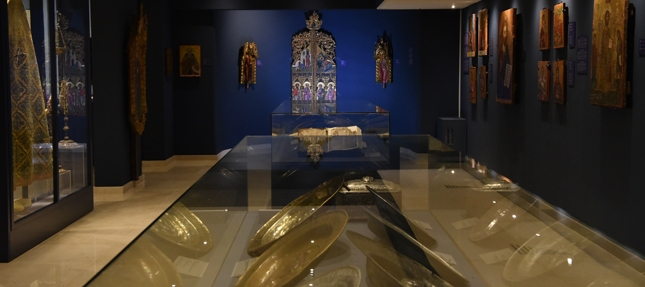
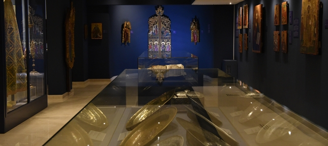
The Byzantine Museum of Holy Bishopric of Tamasos and Oreinis is situated inside the Bishopric Palace, in the community of Episkopeio, Lefkosia  (Nicosia).

In the Museum byzantine and post-byzantine artefacts are exhibited, dating from the 5th to the early 20th centuries. Among them you can find icons, liturgical objects, priestly habits, manuscripts, coins, ceramic and other religious objects, mostly coming from several communities of the bishopric region.

The most interesting artefacts are: dedicatory inscription of a paleochristian building from Tamasos (5th century), wooden painted cross (13th century), brass reliquary cross (10th century), brass dishes (15th – 16th century), part of the numismatic hoard of Achera (12th century), Lectionary manuscript (16th century), etc.

Region: Lefkosia
Address: Stavros Stylianides Avenue, 2642 Episkopeio, Lefkosia
Contact No: Tel: +357 22 465 465 and +357 99 774 770
Operating Hours: Monday – Friday: 09:00 – 13:00
Operating Period: All year round.
Closed on Public Holidays.
Entrance Fee: Free
Disabled Access: Accessible for people in wheelchairs.
Website: https://www.facebook.com/byzantine.museum.tamasos
  Opening and closing times as well as entrance fees, are subject to alterations without notice. Visitors are advised to check before visiting.

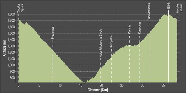
Troodos 1 – Troodos – Agios Nikolaos Stegis – Troodos Cycling Route

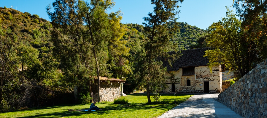
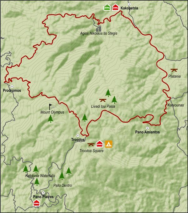
This route descends from Troodos square to the monastery of Agios Nikolaos tis Stegis and climbs steadily from the chromium quarry on the Troodos – Karvounas road, back to Troodos square.

After the Prodromos crossroads, the route goes along a forest road to Agios Nikolaos. From there the it goes along the paved road from Kakopetria to Karvounas, turns right and then climbs Troodos. After almost 9 kilometers of steep uphill the route goes past the Troodos Geopark Information Center in Amiantos. It then reaches the Troodos – Prodromos road and turns left to return to Troodos square.

Difficulty rate: A very difficult route. It requires a 20-speed road bike in good condition.
Road condition: Paved throughout.

To download the route in gpx format click here

Distance: 37.7km
Elevation Gain: 1635m
Highest point: 1824m
Lowest point: 726m
Loop: YES
Terrain: Mountain
Road surface: Paved
Section Distance (km) Total Distance (km)
Troodos Square 0,0 0,0
Prodromos 8,2 8,2
Ag. Nikolaos tis Stegis 11,6 19,8
Kakopetria 2,6 22,4
Platania 4,5 26,9
Karvounas 2,3 29,2
Pano Amiantos 2,3 31,5
Troodos Square 6,2 37,7

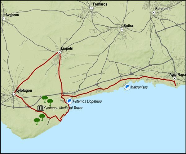
Ammochostos 1 – Agia Napa – Pyrgos Xylofagou Cycling Route

This excursion does the round from Agia Napa to Xylofagou and comes back along the Xylofagou – Agia Napa road.
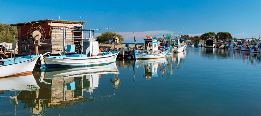
The route begins at the little harbour of Agia Napa and climbs towards the north until it reaches the traffic lights where it turns left and to the west, going along the bicycle path on the left hand side of the road. It then goes past Makronisos on the dirt road that leads to the Agia Thekla chapel and the fishing shelter by the Potamos Liopetriou.
Heading south it goes round Cape Pyla, until it reaches the Xylofagou Medieval Tower. From there it takes a northern course to reach the outskirts of Xylofagou and turns right and to the east taking the Xylofagou – Agia Napa road back to Agia Napa.

Difficulty rate: An easy route but it requires a 21-speed mountain bike.
Road condition: A combination of paved and unpaved roads.

To download the route in gpx format click here

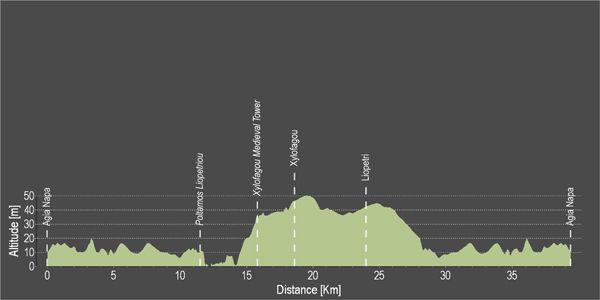
Distance: 38.1Km
Elevation Gain: 78m
Highest point: 51m
Lowest point: 1m
Loop: YES
Terrain: Flat
Road surface: Mixed
Section Distance (km) Total Distance (km)
Agia Napa 0,0 0,0
Potamos Liopetriou 11,4 11,4
Xylofagou Medieval Tower 4,4 15,8
Xylofagou 2,8 18,6
Liopetri 5,4 24,0
Agia Napa 14,1 38,1

Ezousa Walking Trail (Circular), Pafos (Paphos) District

GPS coordinates of the starting point: Lat: 34.791653 Lon: 32.523179
GPS coordinates of the ending point: Lat: 34.791653 Lon: 32.523179
Altitude of the starting point: 247m
Altitude of the highest peak: 247m
Altitude of the end peak: 247m
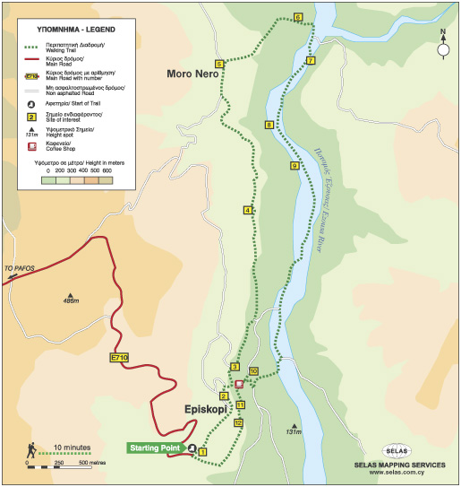
Starting point: Environmental Information Centre of Episkopi Pafos (Paphos).
Length: 7.6km
Estimated duration: 3 hours
Difficulty rate: 2 (downhill and uphill gradient around Ezousa Valley)


Points of interest: The Environmental Information Centre houses exhibition areas with scenes and exhibits, as well as showing documentaries about the natural environment and biodiversity of the surrounding area.

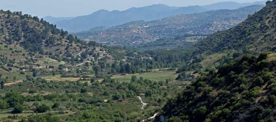
There are excellent views along the way but the most impressive view is from the “Rock” on which the village church, devoted Saint Ilarion the Great, is built. Here, you can enjoy uninterrupted views of the Ezousa Valley below as well as taking in the beauty of nature itself. From this particular point, visibility extends to the Pafos forest and the mountain range of Troodos. The trail crosses over the Ezousa Valley at a certain point with lush growth, especially Oriental Plane Tree and Oriental Alder which offer shade to travelers on hot summer days, making the walk a unique and pleasant experience.

Flora: While walking you can study these indigenous plants: Cyprus cyclamen (Cyclamen cyprium), Bosea (Bosea cypria), Oleander (Nerium oleander), Oriental alder (Alnus orientalis), Oriental plane tree (Platanus orientalis), Oak tree (Quercus infectoria), Locust tree (Ceratonia siliqua), Terebinths (Pistacia Terebinthus), Kermes oak (Quercus coccifera), Spiny broom (Calicotome villosa).

Musée ecclésiastique – village de Sotira

Situé dans le village de Sotira, dans la chapelle de Saint George, le musée ecclésiastique expose d’importants trésors religieux, tels que des icônes sacrées (dont une du XVe siècle représentant Jésus-Christ), des évangiles de forme ancienne, des livres liturgiques, des croix ainsi que divers objets dont des objets de culte. Il abrite également un des trois seuls autels portatifs en bois qui existent à Chypre, datant du XVIe siècle.

À côté du musée se trouve l’église «tis Metamorphoseos tou Sotiros» [De la Transfiguration du Sauveur]. Cette église en pierre, à une nef voûtée, a été construite sur les fondations d’une basilique byzantine paléochrétienne.

Le grand nombre d’églises de l’époque byzantine se trouvant à proximité, reflète l’importance de ce village durant cette période.

Région: Ammochostos (Famagouste)
Adresse: Village de Sotira
No à contacter: Tél.: +357 23 823 932
Horaires d’ouverture: Sur rendez-vous.
Période d’ouverture: Toute l’année.
Hors jours fériés.
Tarifs: Gratuit (les dons sont les bienvenus).
Site Internet: www.sotira.org.cy
  Les horaires d’ouverture, ainsi que les tarifs, sont sujets à modification sans préavis. Nous vous invitons à vous renseigner avant la visite.


Centre culturel de la Municipalité d’Ammochostos (Famagouste)

Le centre culturel de la ville occupée d’Ammochostos (Famagouste) a été créé afin d’accueillir régulièrement conférences et séminaires d’information, sur le sujet crucial de la «question chypriote», suite à l’invasion turque de 1974 ayant comme conséquence la division de l’île.

Des jumelles sont à disposition du public pour observer la ville occupée d’Ammochostos. Sur place, on peut aussi voir une petite exposition de photographies.

Région: Ammochostos
Adresse: 35, Evagorou, Village de Deryneia
No à contacter: Tél: +357 23 740 860, Fax: +357 23 740 861
Horaires d’ouverture: Horaires d’ouverture d’été (8.5 – 1.11) :
Lundi vendredi : 07h30 -17h00
Samedi : 07h30-15h00

Horaires d’ouverture d’hiver (4.11 – 5.5) :
Du lundi au samedi : de 7h30 à 15h00
Pendant ces heures, le Centre Culturel est ouvert au public. Pour les visites organisées et guidées, vous pouvez appeler le +357 23740860 ou envoyer un e-mail à [email protected]

Période d’ouverture: Toute l’année.
Hors jours fériés.
Tarifs: Gratuit
Accessibilité: Accessible aux personnes à mobilité réduite.
Site internet: www.famagusta.org.cy
  Les horaires d’ouverture, ainsi que les tarifs, sont sujets à modification sans préavis. Nous vous invitons à vous renseigner avant la visite.


Site Archéologique de la Cité Antique d’Idalion

Le site archéologique d’Idalion, dans la région du village de Dali, est l’un des plus importants sites de Chypre. De nombreuses pièces de sa riche collection de découvertes sont actuellement exposées dans des musées parmi les plus prestigieux du monde.

La cité antique fut fondée par Chalcanor, héros achéen de la guerre de Troie et descendant de Teucros, le fondateur de Salamis. Selon la légende, l’Idalion antique est le lieu où Adonis, le bien-aimé d’Aphrodite, fut tué par son amant jaloux Arès, le dieu olympien de la guerre.

Le royaume prospéra jusqu’au milieu du Ve siècle avant J-C, lorsque sa capitale fut assiégée et occupée par les rois phéniciens de Kition. Les fouilles ont permis de mettre au jour des découvertes provenant aussi bien de la cité que des cimetières de la région. Les plus anciens vestiges témoignant de présence humaine dans la région furent trouvés au lieu-dit d’Agridi et remontent aux  7ème et 5ème millénaires avant J-C.

Il existe sur place un centre d’accueil pour les visiteurs et un musée exposant ces découvertes.

Le site est une des étapes de la route culturelle d’Aphrodite.

Région: Lefkosia (Nicosie)
Adresse: Village de Dali
No à contacter: Tél.: +357 22 444 818
Horaires d’ouverture: Du lundi au vendredi: 08h30 – 16h00
Fermé samedi et dimanche.
Période d’ouverture: Toute l’année.
Hors jours fériés.
Tarifs: €2,50
Pour des visites organisées en groupe de plus de 10 personnes, une réduction de 20% s’applique sur le tarif.
Le département des Antiquités peut émettre des cartes d’entrée forfaitaires valables dans l’ensemble de ses musées et monuments historiques.
Carte valable: 1 jour: €8,50 / 3 jours: €17,00 / 7 jours: €25,00.
Accessibilité: Accessible aux personnes à mobilité réduite.
Site Internet: www.mcw.gov.cy/da
  Les horaires d’ouverture, ainsi que les tarifs, sont sujets à modification sans préavis. Nous vous invitons à vous renseigner avant la visite.


Découvrez la beauté de Chypre à EuroVelo8

Offrez vous le plaisir d’explorer, à vélo, la beauté naturelle de l’île, en empruntant nos itinéraires et excursions conseillés, tous pensés dans le souci de vous «mettre sur la bonne voie» et vous faire découvrir les paysages époustouflants de l’île.

Les excursions peuvent être choisies telles que présentées, ou être personnalisées selon vos préférences et envies avec l’aide d’agences de voyages agréées. Pour plus d’informations, suivez ce lien.

Chypre fait également partie du projet cofinancé «Eurovélo 8». Ce projet conduit l’aménagement et la promotion de circuits organisés de cyclotourisme, tant sur un plan national, régional que transnational, le long de la «Route de la Méditerranée européenne Eurovelo 8», qui est l’une des 14 véloroutes formant le réseau «Eurovélo» reliant 11 pays.

L’itinéraire du tronçon Lemesos (Limassol)/Cap Gkreko a été cartographié et les données géographiques GPSdes deux parties de la route –  Marina de Lemesos/Larnaka et Larnaka/Cap Gkreko – peuvent être téléchargées ici. Quant au dossier contenant les étapes des parcours, il peut également être téléchargé ici.

Pour plus d’informations sur EuroVelo, veuillez visiter: www.eurovelo.com

 
Pour plus d’informations sur EuroVelo 8, veuillez visiter: www.eurovelo8.com
 
Pour plus d’informations sur le projet MedCycleTour, veuillez visiter: https://medcycletour.interreg-med.eu/ ou veuillez contacter Thalia Christodoulidou à [email protected].

Bonne balade à vélo !


Vasilikos Maroni Panorama

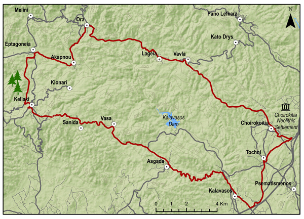
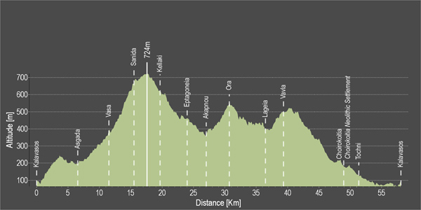
The route starts from the village of Kalavasos with a slight uphill ascent towards the village of Asgata. Pass through the narrow streets of the village and continue uphill to Vasa, Sanida and then to Kellaki. Woodland areas and unique views will be encountered along the way. Ride downhill to reach the Eptagoneia Village and the small picturesque village of Akapnou. Continue towards Ora, Lageia, Vavla and ride further downhill to Choirokoitia. Pass through the village of the picturesque and beautiful Tochni to reach the starting point in Kalavasos.

To download the route in gpx format click here

Distance: 57.6km
Elevation Gain: 1169m
Highest point: 724m
Lowest point: 65m
Loop: YES
Terrain: Mountain
Road surface: Paved
Section Distance (km) Total Distance (km)
Kalavasos 0,0 0,0
Asgada 6.6 6.6
Vasa 5.1 11.7
Sanida 3.6 15.3
Kellaki 4.1 19.4
Eptagonia 4.5 23.9
Akapnou 3.0 26.9
Ora 3.5 30.4
Lageia 6.3 36.7
Vavla 2.4 39.1
Choirokoitia 9.7 48.8
Choirokoitia Neolithic Settlement 0.0 48.8
Tochni 2.8 51.6
Kalavasos 6.0 57.6