Byzantine Museum of the Holy Bishopric of Tamasos and Oreinis

The Byzantine Museum of Holy Bishopric of Tamasos and Oreinis is situated inside the Bishopric Palace, in the community of Episkopeio, Lefkosia  (Nicosia).

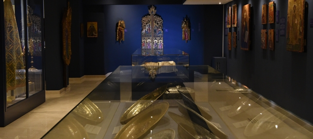
In the Museum byzantine and post-byzantine artefacts are exhibited, dating from the 5th to the early 20th centuries. Among them you can find icons, liturgical objects, priestly habits, manuscripts, coins, ceramic and other religious objects, mostly coming from several communities of the bishopric region.

The most interesting artefacts are: dedicatory inscription of a paleochristian building from Tamasos (5th century), wooden painted cross (13th century), brass reliquary cross (10th century), brass dishes (15th – 16th century), part of the numismatic hoard of Achera (12th century), Lectionary manuscript (16th century), etc.

Region: Lefkosia
Address: Stavros Stylianides Avenue, 2642 Episkopeio, Lefkosia
Contact No: Tel: +357 22 465 465 and +357 99 774 770
Operating Hours: Monday – Friday: 09:00 – 13:00
Operating Period: All year round.
Closed on Public Holidays.
Entrance Fee: Free
Disabled Access: Accessible for people in wheelchairs.
Website: https://www.facebook.com/byzantine.museum.tamasos
  Opening and closing times as well as entrance fees, are subject to alterations without notice. Visitors are advised to check before visiting.

Troodos 1 – Troodos – Agios Nikolaos Stegis – Troodos Cycling Route


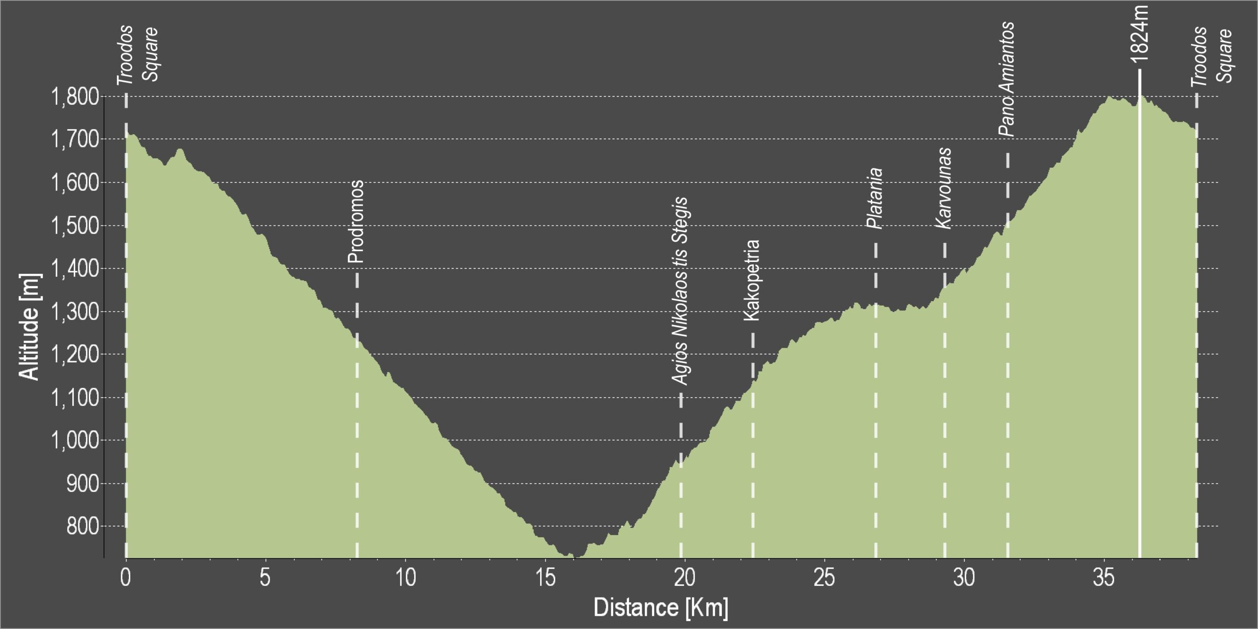
This route descends from Troodos square to the monastery of Agios Nikolaos tis Stegis and climbs steadily from the chromium quarry on the Troodos – Karvounas road, back to Troodos square.

After the Prodromos crossroads, the route goes along a forest road to Agios Nikolaos. From there the it goes along the paved road from Kakopetria to Karvounas, turns right and then climbs Troodos. After almost 9 kilometers of steep uphill the route goes past the Troodos Geopark Information Center in Amiantos. It then reaches the Troodos – Prodromos road and turns left to return to Troodos square.

Difficulty rate: A very difficult route. It requires a 20-speed road bike in good condition.
Road condition: Paved throughout.

To download the route in gpx format click here

Distance: 37.7km
Elevation Gain: 1635m
Highest point: 1824m
Lowest point: 726m
Loop: YES
Terrain: Mountain
Road surface: Paved
Section Distance (km) Total Distance (km)
Troodos Square 0,0 0,0
Prodromos 8,2 8,2
Ag. Nikolaos tis Stegis 11,6 19,8
Kakopetria 2,6 22,4
Platania 4,5 26,9
Karvounas 2,3 29,2
Pano Amiantos 2,3 31,5
Troodos Square 6,2 37,7

Ammochostos 1 – Agia Napa – Pyrgos Xylofagou Cycling Route

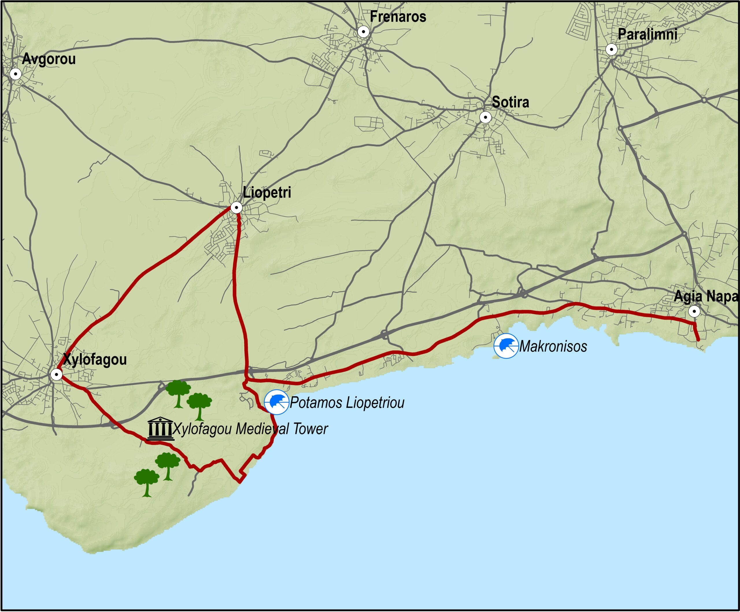
This excursion does the round from Agia Napa to Xylofagou and comes back along the Xylofagou – Agia Napa road.
The route begins at the little harbour of Agia Napa and climbs towards the north until it reaches the traffic lights where it turns left and to the west, going along the bicycle path on the left hand side of the road. It then goes past Makronisos on the dirt road that leads to the Agia Thekla chapel and the fishing shelter by the Potamos Liopetriou.
Heading south it goes round Cape Pyla, until it reaches the Xylofagou Medieval Tower. From there it takes a northern course to reach the outskirts of Xylofagou and turns right and to the east taking the Xylofagou – Agia Napa road back to Agia Napa.

Difficulty rate: An easy route but it requires a 21-speed mountain bike.
Road condition: A combination of paved and unpaved roads.

To download the route in gpx format click here

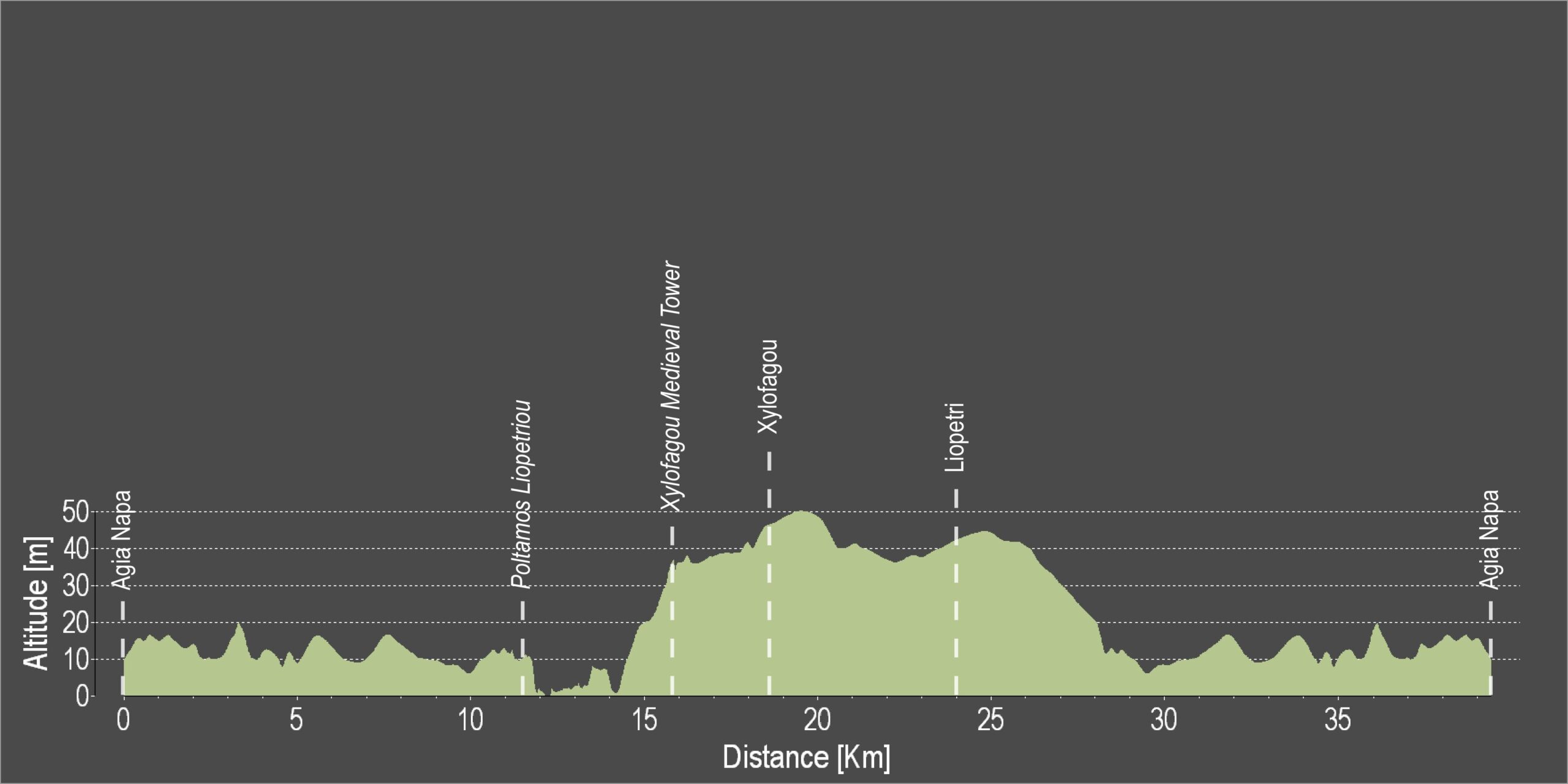
Distance: 38.1Km
Elevation Gain: 78m
Highest point: 51m
Lowest point: 1m
Loop: YES
Terrain: Flat
Road surface: Mixed
Section Distance (km) Total Distance (km)
Agia Napa 0,0 0,0
Potamos Liopetriou 11,4 11,4
Xylofagou Medieval Tower 4,4 15,8
Xylofagou 2,8 18,6
Liopetri 5,4 24,0
Agia Napa 14,1 38,1

Ezousa Walking Trail (Circular), Pafos District

GPS coordinates of the starting point: Lat: 34.791653 Lon: 32.523179
GPS coordinates of the ending point: Lat: 34.791653 Lon: 32.523179
Altitude of the starting point: 247m
Altitude of the highest peak: 247m
Altitude of the end peak: 247m
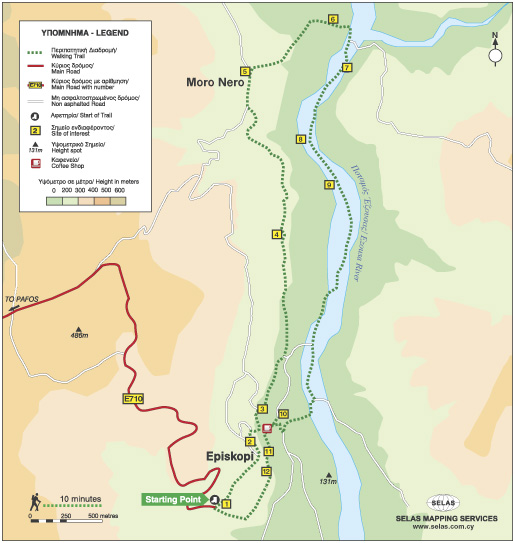
Starting point: Environmental Information Centre of Episkopi Pafos.
Length: 7.6km
Estimated duration: 3 hours
Difficulty rate: 2 (downhill and uphill gradient around Ezousa Valley)


Points of interest: The Environmental Information Centre houses exhibition areas with scenes and exhibits, as well as showing documentaries about the natural environment and biodiversity of the surrounding area.

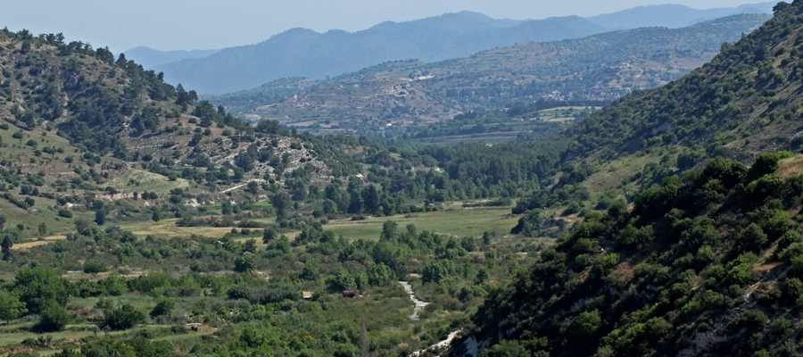
There are excellent views along the way but the most impressive view is from the “Rock” on which the village church, devoted Saint Ilarion the Great, is built. Here, you can enjoy uninterrupted views of the Ezousa Valley below as well as taking in the beauty of nature itself. From this particular point, visibility extends to the Pafos forest and the mountain range of Troodos. The trail crosses over the Ezousa Valley at a certain point with lush growth, especially Oriental Plane Tree and Oriental Alder which offer shade to travelers on hot summer days, making the walk a unique and pleasant experience.

Flora: While walking you can study these indigenous plants: Cyprus cyclamen (Cyclamen cyprium), Bosea (Bosea cypria), Oleander (Nerium oleander), Oriental alder (Alnus orientalis), Oriental plane tree (Platanus orientalis), Oak tree (Quercus infectoria), Locust tree (Ceratonia siliqua), Terebinths (Pistacia Terebinthus), Kermes oak (Quercus coccifera), Spiny broom (Calicotome villosa).

Церковный музей – деревня Сотира

Расположенный в часовне Святого Георгия в деревне Сотира Церковный Музей демонстрирует такие редкие религиозные сокровища, как святые иконы (в том числе Иисуса Христа 15-го века), старые формы Евангелий, литургические книги, кресты, литургические сосуды и другие артефакты. Здесь же находится один из трех портативных деревянных алтарей 16-го века, которые существуют на Кипре.

Рядом с музеем находится церковь Преображения (Спасо-Преображенская). Это каменная сводчатая церковь, построенная на фундаменте более ранней византийской базилики.

Сама деревня играла значительную роль во времена Византии, что отражено в ряде старых церквей, существующих в непосредственной близости от нее.

Район: Аммохостос (Фамагуста)
Адрес: Деревня Сотира
Контактный No.: Тел: +357 23 823 932
Часы работы: По предварительной записи.
Период работы: Круглый год.
Закрыта в праздничные дни.
Стоимость билета: Бесплатно (принимаются пожертвования).
Веб-сайт: www.sotira.org.cy
  Часы работы, а также стоимость билетов могут быть изменены без предварительного уведомления. Посетителям рекомендуется проверить информацию перед посещением.


Культурный центр муниципалитета Аммохостос (Фамагуста)

Посвященный оккупации района Аммохостос (Фамагуста) Культурный Центр был создан, чтобы проводить регулярные презентации и брифинги относительно «Кипрской проблемы», возникшей в результате разделения острова после турецкого вторжения в 1974 году.

В наличии есть бинокли для просмотра оккупированного города Аммохостос (Фамагуста), а также небольшая фотовыставка.

Район: Аммохостос
Адрес: Эвагору 35, деревня Дериния
Контактный No.: Тел: +357 23 740 860, факс: +357 23 740 861
Часы работы: Летние часы работы (8.5 – 1.11):
Понедельник Пятница: 07:30 -17:00
Суббота: 07:30-15:00

Зимний режим работы (4.11 – 5.5):
Понедельник – Суббота: 07:30 – 15:00.

В эти часы Культурный центр открыт для публики. Для организованных экскурсий и экскурсий вы можете позвонить по телефону +357 23740860 или отправить электронное письмо по адресу[email protected].

Период работы: Круглый год.
Закрыт в праздничные дни.
Стоимость билета: Бесплатно
Удобства для инвалидов: Доступен для инвалидов.
Веб-сайт: www.famagusta.org.cy
  Часы работы, а также стоимость билетов могут быть изменены без предварительного уведомления. Посетителям рекомендуется проверить информацию перед посещением.


Территория Археологических Раскопок Древнего Идалиона

Археологические раскопки в Идалионе, в районе деревни Дали, являются одним из самых важных мест на Кипре. Богатые находки в настоящее время выставлены в некоторых из самых знаменитых музеев мира.

Древний город был основан ахейским героем Троянской войны Халканором, потомком Тевкра, основателя Саламины. Согласно легенде, в Древнем Идалионе возлюбленный Афродиты Адонис был убит из ревности Олимпийским Богом войны Аресом.

Царство процветало до середины 5го века до н.э., когда его столица была осаждена и захвачена финикийским царем Китиона. В обоих поселениях и могильниках в округе были обнаружены находки, являющиеся самыми ранними остатками человеческой жизнедеятельности в местности Агриди, начиная с 7го и 5го веков до нашей эры.

Здесь находится музей и Туристический центр, который продемонстрирует находки, а также это место связано с культурным маршрутом Афродиты.

Район: Лефкосия (никосия)
Адрес: Деревня Дали
Контактный No.: Тел: +357 22 444 818
Часы работы: Понедельник – пятница: 08:30 – 16:00
Закрыта по выходным.
Период работы: Круглый год.
Закрыта в праздничные дни.
Стоимость билета: €2,50
Для организованных групп, состоящих из более 10 человек скидка на входные билеты 20%.
Департамент древностей выдает специальные карточки входа для всех своих музеев и древних памятников: Один (1) день действия карты – €8,50, три (3) дня – €17,00, семь (7) дней – €25,00.
Удобства для инвалидов: Доступна для инвалидов.
Веб-сайт: www.mcw.gov.cy/da
  Часы работы, а также стоимость билетов могут быть изменены без предварительного уведомления. Посетителям рекомендуется проверить информацию перед посещением.


European Mediterranean Route EuroVelo 8

Discover and enjoy the natural beauty of the island from the pedal of a bike with our suggested itineraries, all created to put you on the ‘right track’ and showcase Cyprus’ stunning landscape.

Cyprus is also part of the cofunded project ‘MedCycleTour’, which is based on the ‘European Mediterranean Route – EuroVelo 8’, one of the 15 long distance cycle routes in the network ‘EuroVelo’ that connects 11 countries. ‘MedCycleTour’ aims to develop cycle tourism in the Mediterranean region by providing transnational tools to attract visitors. The project is cofunded by the Interreg Mediterranean Programme, the project has a budget of over €2,5 million.

The MedCycleRoute project will contribute to the development of the EuroVelo 8 – Mediterranean Route by exchanging good practices; surveying the existing cycle route; developing regional and transnational action plans; preparing and publishing promotional material related to EuroVelo 8; and implementing pilot projects such as signposting, promotional tools (web sites, apps, etc.) and cycle friendly schemes.

Lead by the Andalusian Government – Agency of Public Works, Andalusian Ministry of Development and Housing (Spain) -, the project has 10 other partners from 7 countries, besides the Deputy Ministry of Tourism. The European Cyclists´ Federation (Belgium), Alpes Maritimes (France), Catalonia Region (Spain), Western Greece (Greece), Friuli Venezia Giulia Region (Italy), Province of Mantova (Italy), Regional Development Center of Koper (Slovenia), Croatian National Tourism Board (Croatia) and the Cluster for Eco-Social Innovation and Development (Croatia).

For more information about EuroVelo please visit: www.eurovelo.com

For more information about EuroVelo 8 please visit: www.eurovelo8.com

For more information about MedCycleTour project please visit: https://medcycletour.interreg-med.eu/ or please contact [email protected].

Happy cycling!

Vasilikos Maroni Panorama

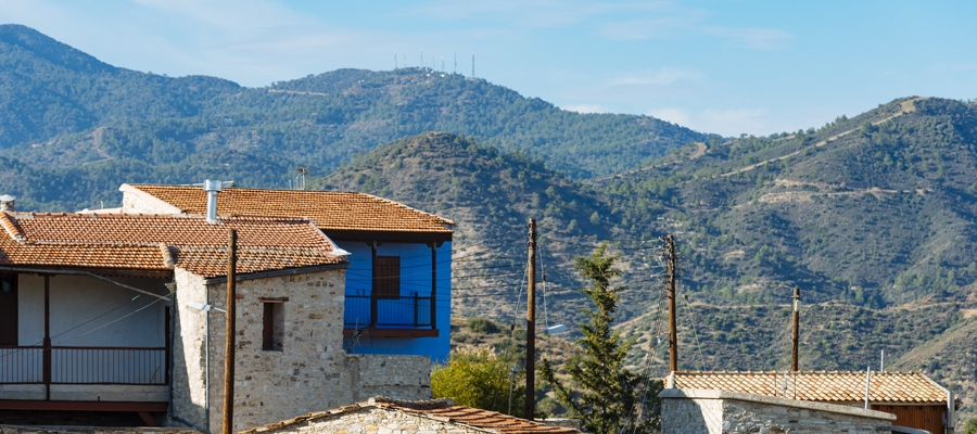
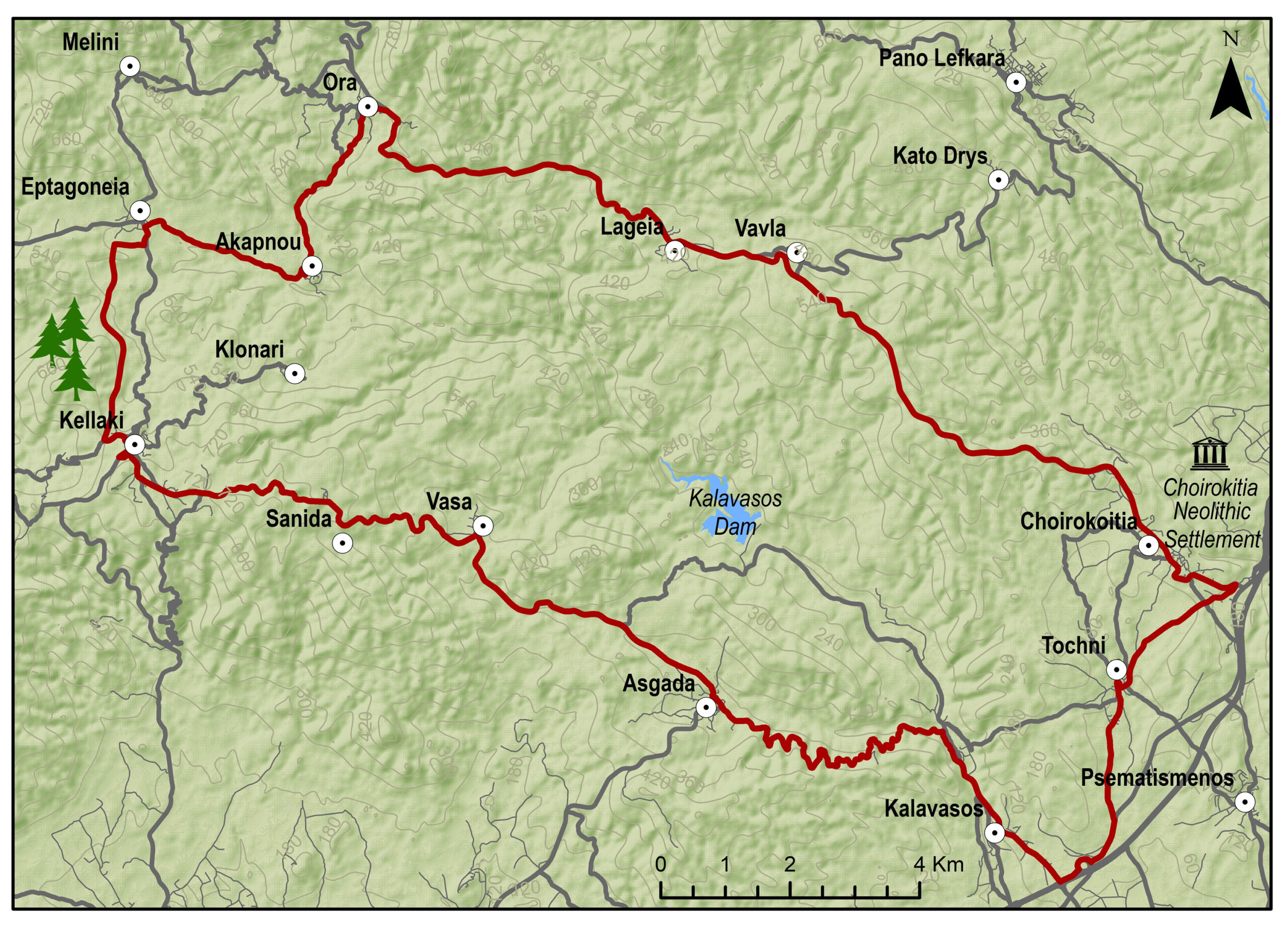
The route starts from the village of Kalavasos with a slight uphill ascent towards the village of Asgata. Pass through the narrow streets of the village and continue uphill to Vasa, Sanida and then to Kellaki. Woodland areas and unique views will be encountered along the way. Ride downhill to reach the Eptagoneia Village and the small picturesque village of Akapnou. Continue towards Ora, Lageia, Vavla and ride further downhill to Choirokoitia. Pass through the village of the picturesque and beautiful Tochni to reach the starting point in Kalavasos.

To download the route in gpx format click here

Distance: 57.6km
Elevation Gain: 1169m
Highest point: 724m
Lowest point: 65m
Loop: YES
Terrain: Mountain
Road surface: Paved
Section Distance (km) Total Distance (km)
Kalavasos 0,0 0,0
Asgada 6.6 6.6
Vasa 5.1 11.7
Sanida 3.6 15.3
Kellaki 4.1 19.4
Eptagonia 4.5 23.9
Akapnou 3.0 26.9
Ora 3.5 30.4
Lageia 6.3 36.7
Vavla 2.4 39.1
Choirokoitia 9.7 48.8
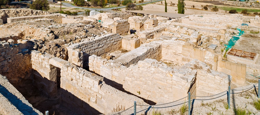
Choirokoitia Neolithic Settlement 0.0 48.8
Tochni 2.8 51.6
Kalavasos 6.0 57.6

Vasilikos Maroni Panorama Intense

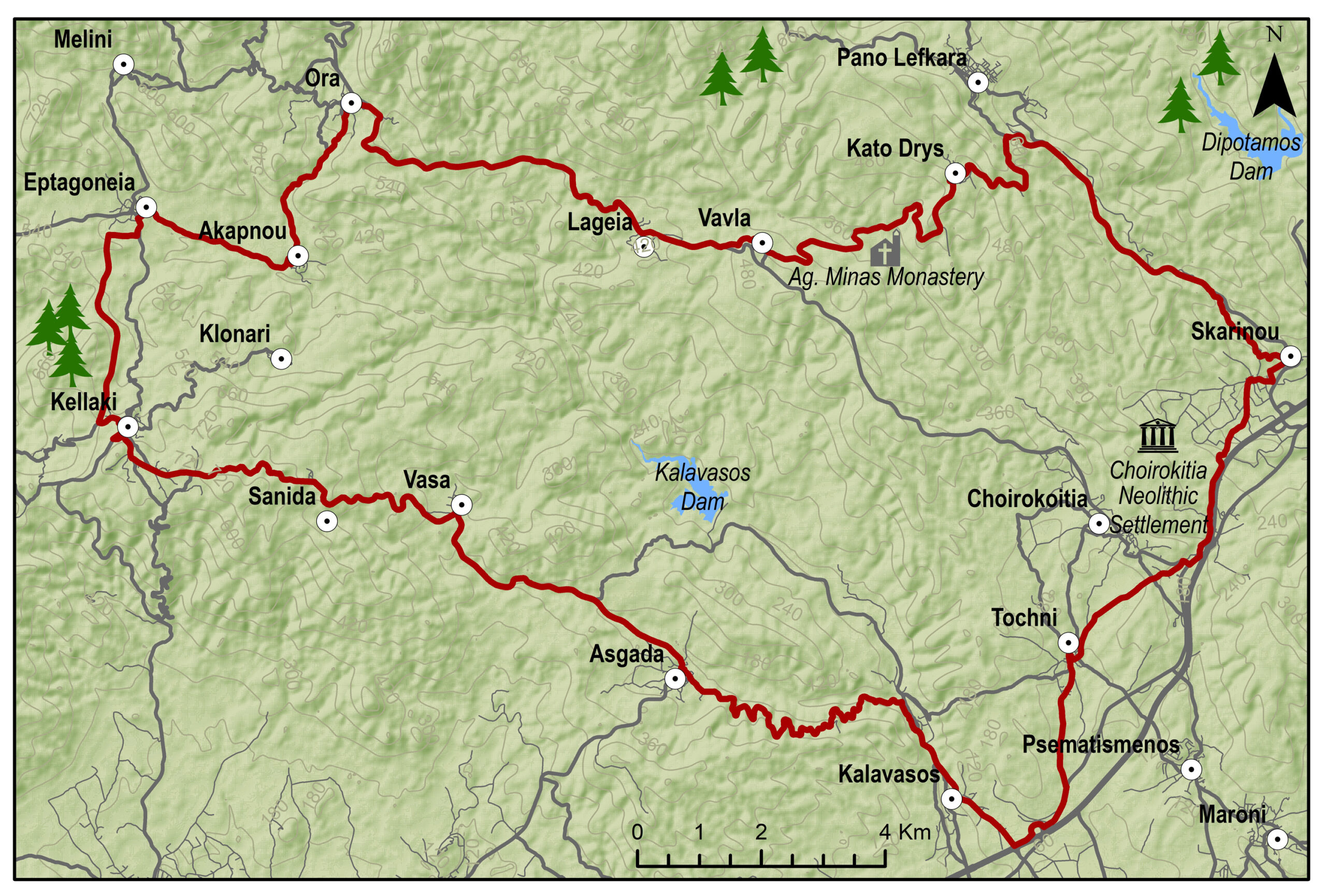
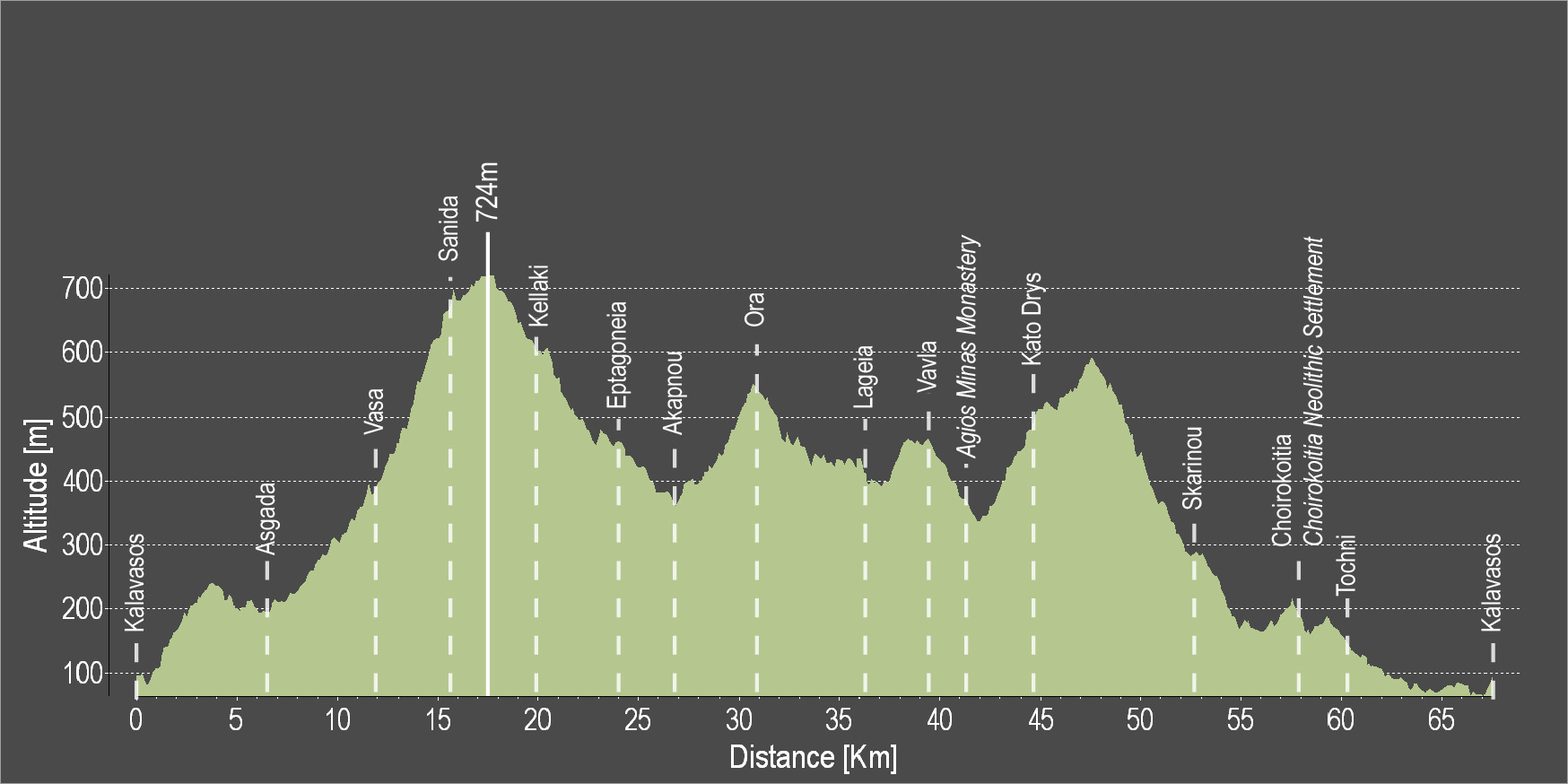
The route starts from the village of Kalavasos with a slight uphill ascent towards the village of Asgata. Pass through the narrow streets of the village and continue uphill to Vasa, Sanida and then to Kellaki. Woodland areas and unique views will be encountered along the way. Ride downhill to reach the Eptagoneia Village and the small picturesque village of Akapnou. Continue towards Ora, Lageia, Vavla and then ride uphill to Kato Drys village. A big downhill ride will follow which leads to the village of Skarinou. Pass through the village and continue to Choirokoitia and then to beautiful Tochni. Continue straight ahead to reach the starting point of the route in Kalavasos.

To download the route in gpx format click here

Distance: 67.3km
Elevation Gain: 1484m
Highest point: 724m
Lowest point: 65m
Loop: YES
Terrain: Mountain
Road surface: Paved
Section Distance (km) Total Distance (km)
Kalavasos 0.0 0.0
Asgada 6.6 6.6
Vasa 5.1 11.7
Sanida 3.6 15.3
Kellaki 4.1 19.4
Eptagoneia 4.5 23.9
Akapnou 3.0 26.9
Ora 3.5 30.4
Lageia 6.3 36.7
Vavla 2.4 39.1
Agios Minas Monastery 2.4 41.5
Kato Drys 3.1 44.6
Skarinou 9.0 53.6
Choirokoitia 4.1 57.7
Choirokoitia Neolithic Settlement 0.0 57.7
Tochni 2.7 60.4
Kalavasos 6.9 67.3