Adonis (Circular) – Pafos (Paphos) District, Akamas Forest Nature Trail

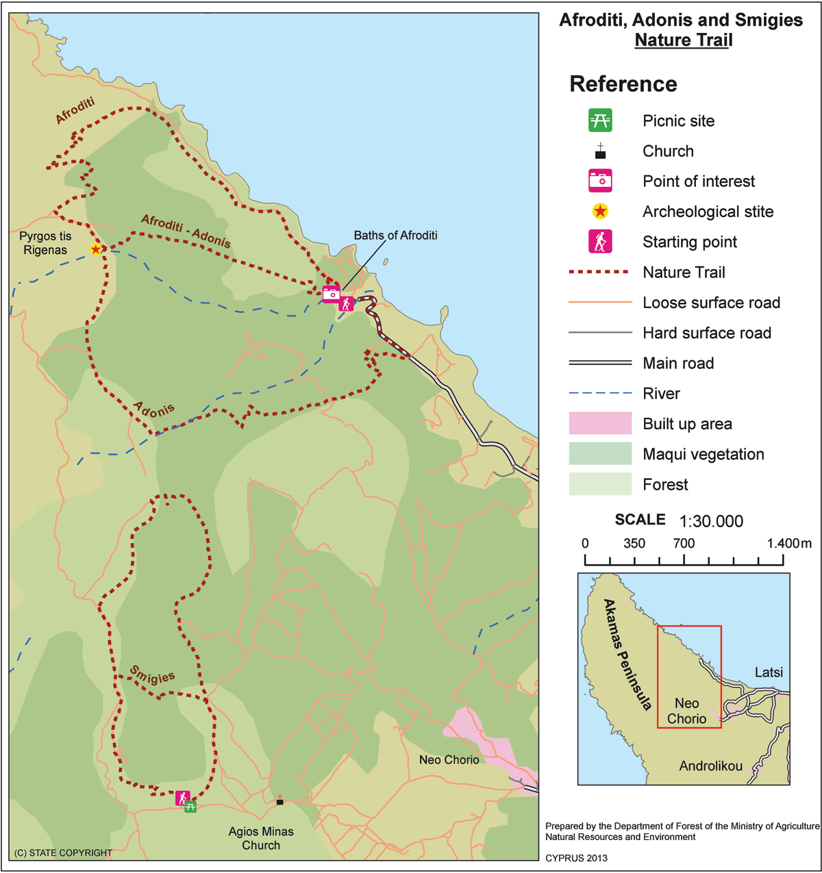
GPS coordinates of the starting point: Lat: 35.056063 Lon: 32.345565
GPS coordinates of the ending point: Lat: 35.056063 Lon: 32.345565
Altitude of the starting point: 35m
Altitude of the highest peak: 319m
Altitude of the end peak: 35m
Starting point: 400m before the Loutra tis Afroditis (Baths of Aphrodite).
Length: 7.5km
Estimated duration: 3 – 4 hours
Difficulty rate: 3


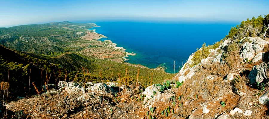
Points of interest: This trail offers beautiful views of Polis Chrysochous, the Pafos (Paphos) Forest and the Akamas peninsula. The path runs past Pyrgos tis Rigainas (Queen’s Tower) and connects with the Smigies trail at Kefalovrysia (where there is a fountain of non­ potable water), and with the Afroditi trail at Pyrgos tis Rigainas. Also noteworthy is the 500 ­year­ old oak tree, which is located near the ruins of the tower. To return full circle, the trail follows the main road that connects the Loutra tis Afroditis (Baths of Aphrodite) with Polis for about 400 metres. At the starting point of the trail you can visit the Botanical Gardens of Akamas.

Flora: While hiking you can study the endemic plants: Cyprus Bosea (Bosea cypria), Shrubby knapweed (Ptilostemon chamaepeuce var. cyprius), Entire – Leaved Horehound (Acanthoprasium integrifolium), Sweet Marjoram (Origanum majorana var. tenuifolium), Cyprus Golden ­ Drop (Onosma fruticosa), Cyprus sage (Phlomis cypria var. occidentalis).

Fauna: The main species of fauna found in the area are:

Mammals: Fox, hare, hedgehog.

Birds: Wood pigeon, partridge, Cyprus warbler (endemic), Cyprus wheatear (endemic).

The forest of Akamas serves as a resting point for many migratory birds.

Reptiles: Cyprus viper, Cyprus lizard, Black whip Snake.

Island Hiking

According to tradition, the best way to really know a place is to walk it. And despite its petite size, the island of Cyprus encapsulates an impressive 10.000 years in its natural environs and diverse landscape that are ripe for exploring and discovering.

With a favourable climate all year round, the great outdoors of the island is easily accessible, and offers a myriad of opportunities to take a journey through nature, history and culture, thanks to the numerous sign­posted paths and nature trails. A total of 52 designated walking trails have been created to highlight the beautiful landscapes and strong Mediterranean character of the island. By walking them, you can see a treasure trove of varied fauna and flora, as well as the remnants of the island’s mining heritage and other interesting monuments.

Whilst some trails are more challenging than others, they are all a delight for the senses ­ especially in the springtime months, when you can experience the sights, sounds and smells of nature in full bloom, and in all its vibrant glory.


Flora

There are 1.908 different plant species, subspecies, varieties, forms and hybrids that have been recorded in Cyprus to date. This number includes native and alien plants (exotic plants that are naturalized), but excludes cultivated plants. There are 142 endemic plants in Cyprus (found exclusively in Cyprus), which comprise the most important part of the island’s flora. Cyprus’ forests are mostly natural woodlands of great biodiversity and major ecological significance. Many of them have been classified as National Forest Parks and protected areas for flora and fauna, covering more than 70 percent of the NATURA 2000 network of the island.

The Calabrian pine (Pinus brutia) is the main forest tree found from the coastal area until an altitude of up to 1.200 – ­1.400 metres, whilst the Black pine (Pinus nigra ssp. pallasiana) dominates in the higher reaches of Troodos.In large rivers and the areas surrounding them, the dominant trees are the oriental plane (Platanus orientalis) and the alder (Alnus orientalis), whilst there are other tree species found on the island on a smaller scale, such as the Cyprus cedar (Cedrus brevifolia) and the Mediterranean Cypress (Cupressus sempervirens).

Bush and shrubland also dominate the landscape. In middle and high elevations, the common bush species of golden oak (Quercus alnifolia) can be spotted on its own, in unmixed forests, or together with pines. In the lowlands you will find maquis shrubland, with dominant species the Phoenician juniper (Juniperus phoenicea), the (wild) olive tree (Olea europaea), the carob tree (Ceratonia siliqua) and the mastic tree (Pistacia lentiscus), as well as the Calabrian pine. Whilst walking along Cyprus’ nature trails you will encounter some of the many endemic plants that are in danger of extinction ­ most of which have been included in the Berne Convention’s list of protected plants. Among these are:

  • The skilla ­ a species of plant of the Hyacinthaceae family (Scilla morrisii)
  • Loch’s Glory­of­the­snow (of Τroodos), (Chionodoxa lochiae)
  • Lefkara’s ankle (Astragalus macrocarpus ssp. Lefkarensis)
  • Kotschy’s orchid (Οphrys kotschyi)
  • The Cyprus tulip (Tulipa cypria)

Fauna

Cyprus also has a wonderful variety of habitats suitable for many species of animal due to the variety of landscapes on the island ­ each with their own particular microclimate and topographical features ­ and the variety of terrains and geological substrates, as well as the diversity of forest and agricultural vegetation.

Among the noteworthy mammals found on the island are:

  • The mouflon (Ovis gmelini ophion) ­ a wild sheep species, found only in Cyprus. It is also the largest wild mammal that exists on the island.
  • The fox (Vulpes vulpes) ­ Cyprus’ only carnivorous mammal.
  • The hedgehog (Hemiechinus auritus dorotheae) ­ an endemic subspecies and a shy and reclusive animal.
  • Bats ­ a remarkable feature of Cypriot fauna, and one of the most peculiar types of mammals, with 19 different species found on the island.

Cyprus’ geographical position makes it one of the most important migratory natural habitats and international birdlife organisations consider it among the most important areas in the world for its biodiversity of birds. It is also a unique location in Europe for endemic birds.

The butterflies of Cyprus, which belong to the order leptidoptera, are also considered of particular interest, with 52 species on the island ­ nine of which are endemic to Cyprus.


Sights of Interest

Aside from the natural bounty you will find on the walking trails, some of the routes have been designed to give visitors the chance to discover Cyprus’ cultural heritage through various monuments that include Byzantine churches (UNESCO World Heritage Sites), Venetian bridges, mosques and other interesting sites.


Degree of Difficulty

All nature trails are divided into three categories of difficulty:

  • Category 1: Easy trail, with gentle gradient. Suitable for all ages and fitness levels.
  • Category 2: Average degree of difficulty, suitable for adults with fair­good fitness levels. Sudden changes in gradient (uphill and/or downhill), and/or course along narrow or rough terrain.
  •  Category 3: High degree of difficulty. Route with difficult terrain such as sudden changes in gradient (uphill and/or downhill), course along particularly rough and/or slippery, and/or narrow and/or steep terrain. Suitable for adults with very good­excellent fitness levels. Unsuitable for young children


Find out More!

Summarised information for each of the 31 hiking trails can be found in this section of the website, whilst a more detailed brochure – which includes valuable advice and tips on how to hike safely and comfortably, as well as maps ­ is available to download here. For more detailed information for the full 52 designated trails from the Forestry Department, click here.

Main 12 – Tour of Marathasa Cycling Route

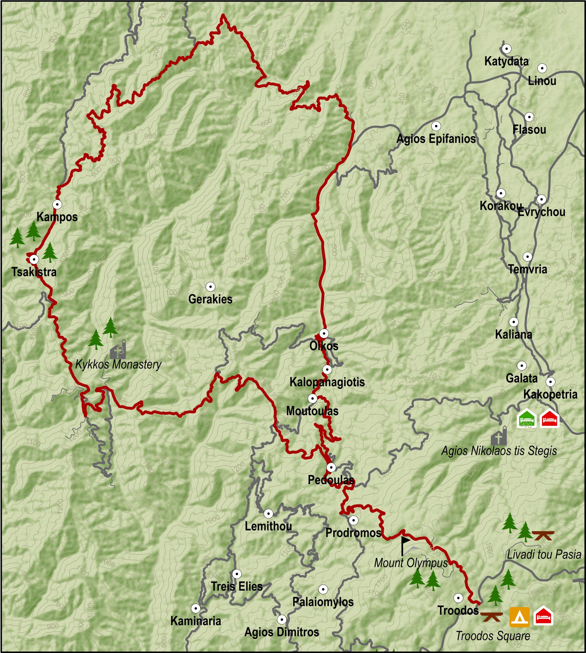
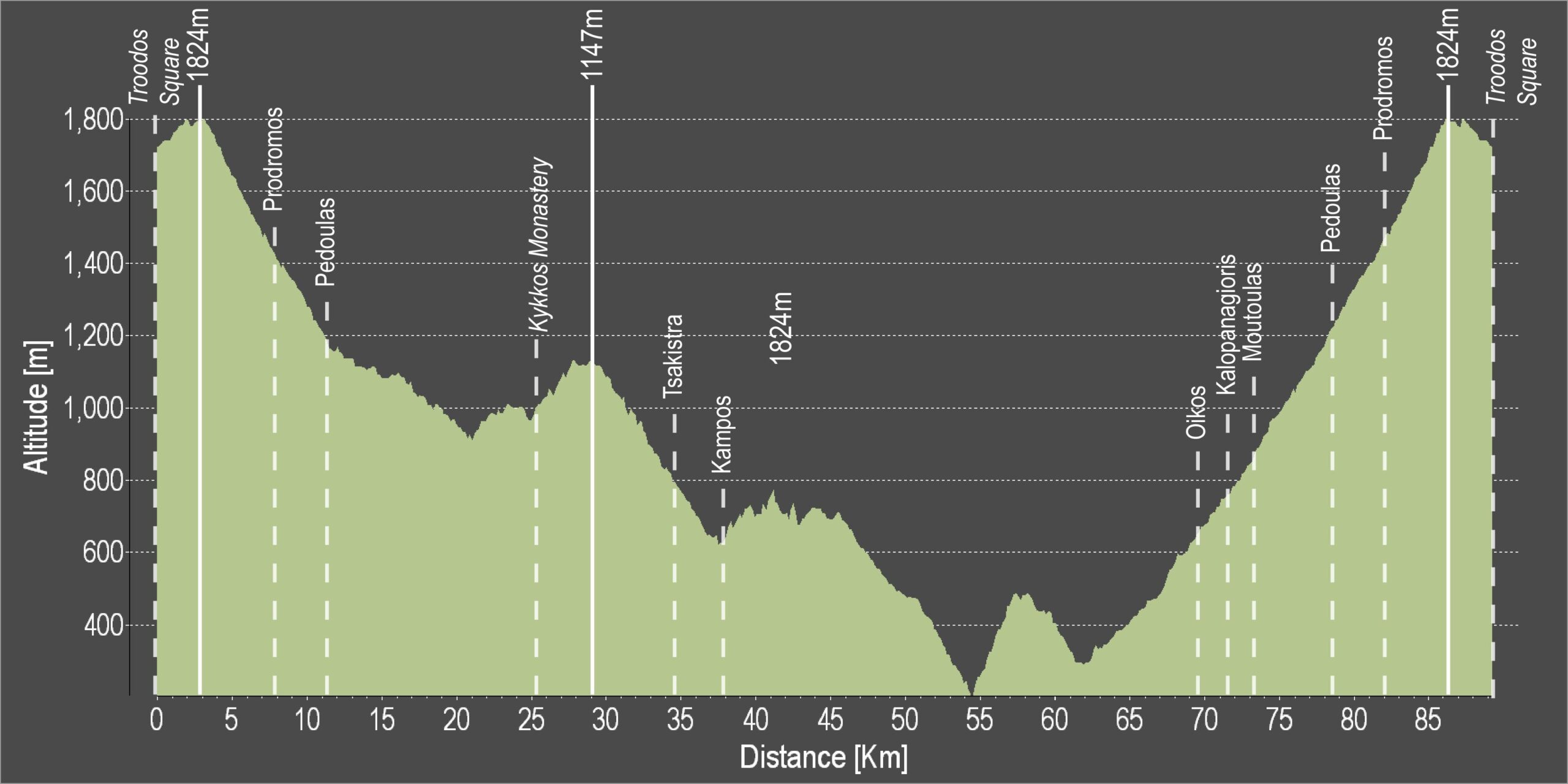
The excursion begins in Troodos square and climbs to the west for about 2.5 kilometres when it reaches a turning to the left leading to Mount Olympos from where it goes downhill to the village of Prodromos. It then turns right to the Pinewood area and travels above the village of Pedoulas to reach Kykkos monastery. Here there is an opportunity to stop at the restaurant before going on to Kampos.

A turning to the left before Kampos leads to Stavros tis Psokas to the west and 3.5 kilometres further down, another turning to the left leads to the Cedar Valley. The route continues straight on for another 16 kilometres until another turning to the left, which leads to the Stavros tis Psokas forestry station 3 kilometers along the way.  Here there is a restaurant, a hostel, a picnic site and a camping site, as well as a fenced off area where mouflon (mountain goats) are kept.

Difficulty rate: Quite a difficult course. It requires a road bike with low/ easy gear ratios
Road condition: Paved roads throughout.
Route Description: This excursion links the Troodos area with the Kykko mountains and enables further trips to the northwest coast of the island, along the route from Stavros to Pyrgos or Polis.

To download the route in gpx format click here

Distance: 90.34km
Elevation Gain: 4746m
Highest point: 1824m
Lowest point: 185m
Loop: YES
Terrain: Mountain
Road surface: Paved
Section Distance (km) Total Distance (km)
Troodos Square 0,0 0,0
Prodromos 8,2 8,2
Pedoulas 3,4 11,6
Kykkos Monastrery 13,7 25,3
Tsakkistra 9,2 34,5
Kampos 2,4 36,9
Oikos 32,6 69,5
Kalopanagiotis 2,2 71,7
Moutoulas 1,4 73,1
Pedoulas 5,8 78,9
Prodromos 3,4 82,3
Troodos Square 8,2 90,5

Main 11 – Troodos – Pafos (Paphos) Cycling Route

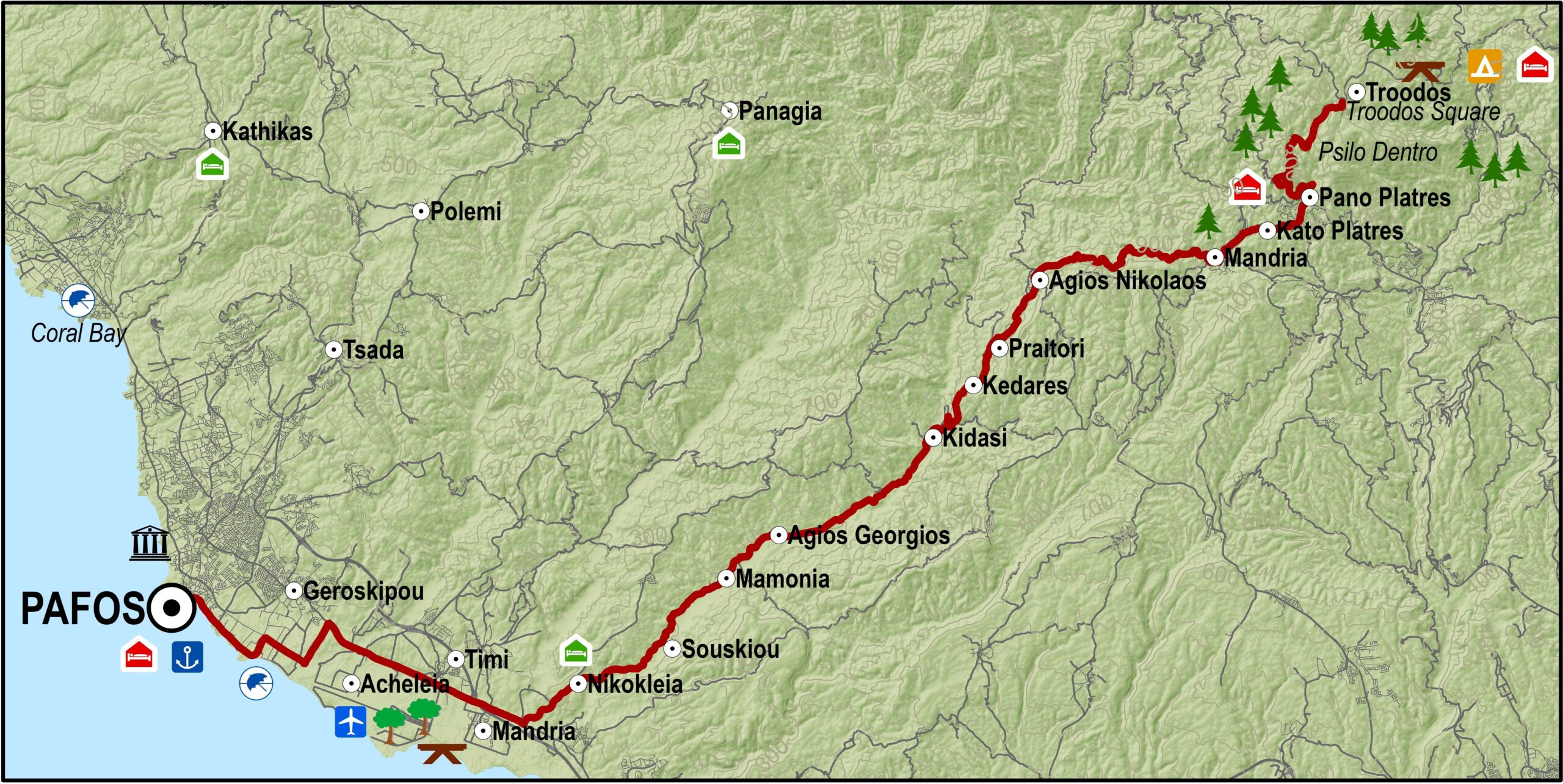
From Troodos square the route heads south along the main Lemesos – Troodos road. At Psilo Dendro it turns right for Pano Platres and then goes on to Kato Platres. Just outside the village it turns right for Mandria and Pafos.

Heading southwest the route goes through Mandria and then enters the Diarizos valley going through the villages of Agios Nikolaos, Praitori, Kedares, Kidasi, Agios Georgios, Mamonia, Fasoula, Nikokleia, finally coming out at the old Lemesos-Pafos road. From there it turns west to reach Pafos via the villages of Mandria, Timi, Acheleia and Geroskipou and then finishes in Pafos Castle.

Road condition: Paved road throughout.
Route Description: This excursion links the Troodos area to Pafos via the picturesque villages in the valley of the Diarizos river.

To download the route in gpx format click here

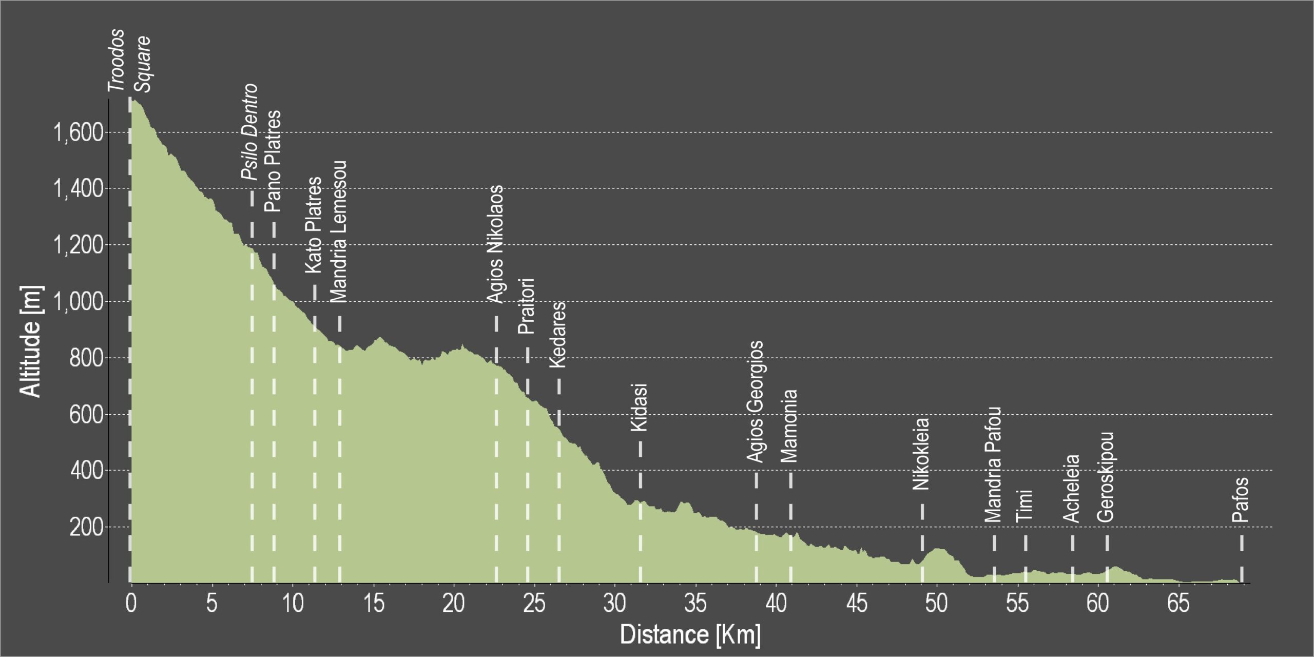
Distance: 68.6km
Elevation Gain: 614m
Highest point: 1735m
Lowest point: 1m
Loop: NO
Terrain: Mountain
Road surface: Paved
Section Distance (km) Total Distance (km)
Troodos square 0,0 0,0
Psilo Dendro 7,6 7,6
Pano Platres 1,3 8,9
Kato Platres 2,6 11,5
Mandria 1,5 13,0
Agios Nikolaos 9,7 22,7
Praitori 1,9 24,6
Kedares 1,7 26,3
Kidasi 5,3 31,6
Agios Georgios 7,2 38,8
Mamonia 2,0 40,8
Nikokleia 8,2 49,0
Mandria 4,6 53,6
Timi 2,1 55,7
Acheleia 2,9 58,6
Geroskipou 1,8 60,4
Pafos 8,2 68,6

Main 13 – Stavros tis Psokas – Pyrgos Cycling Route

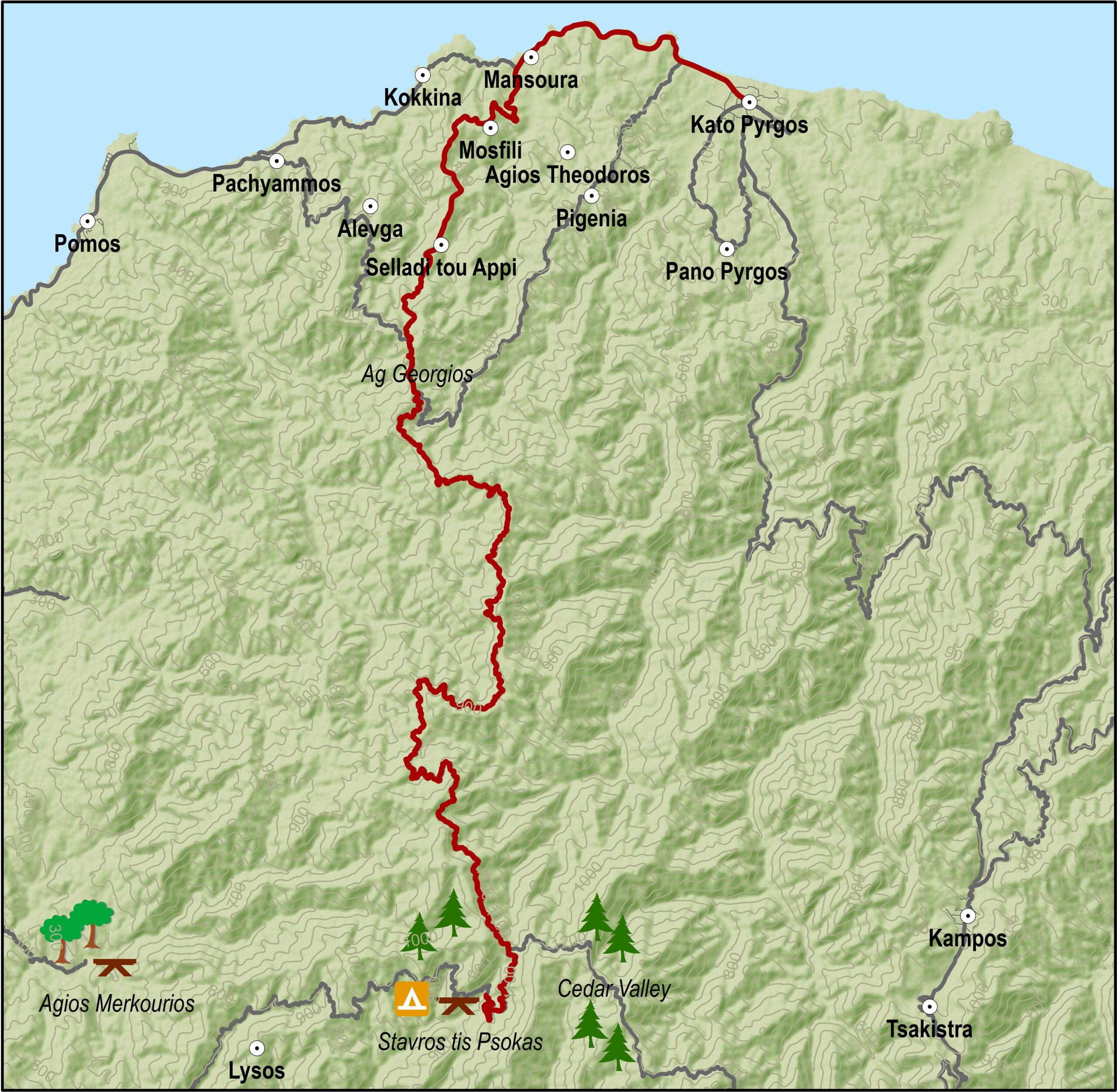
The route starts at the Stavros tis Psokas forestry station. It climbs a little to the north until it reaches a fork. The right-hand road leads east to Kykkos, while the road to the left heads west to Pomos and Kato Pyrgos. The latter is a winding downhill road, which emerges at the military camp of Agios Georgios above the Turkish enclave of Kokkina. From there the route turns right heading east to reach the coastal road and Pyrgos 6 kilometres later.

Difficulty rate: Quite a easy course. It requires a road bike with at least 18 gears.
Road condition: Good quality paved road throughout.
Route Description: This excursion is another alternative from Stavros tis Psokas instead of going to the village of Panagia and Pafos. This excursion leads to Pyrgos in the Tilliria region.

To download the route in gpx format click here

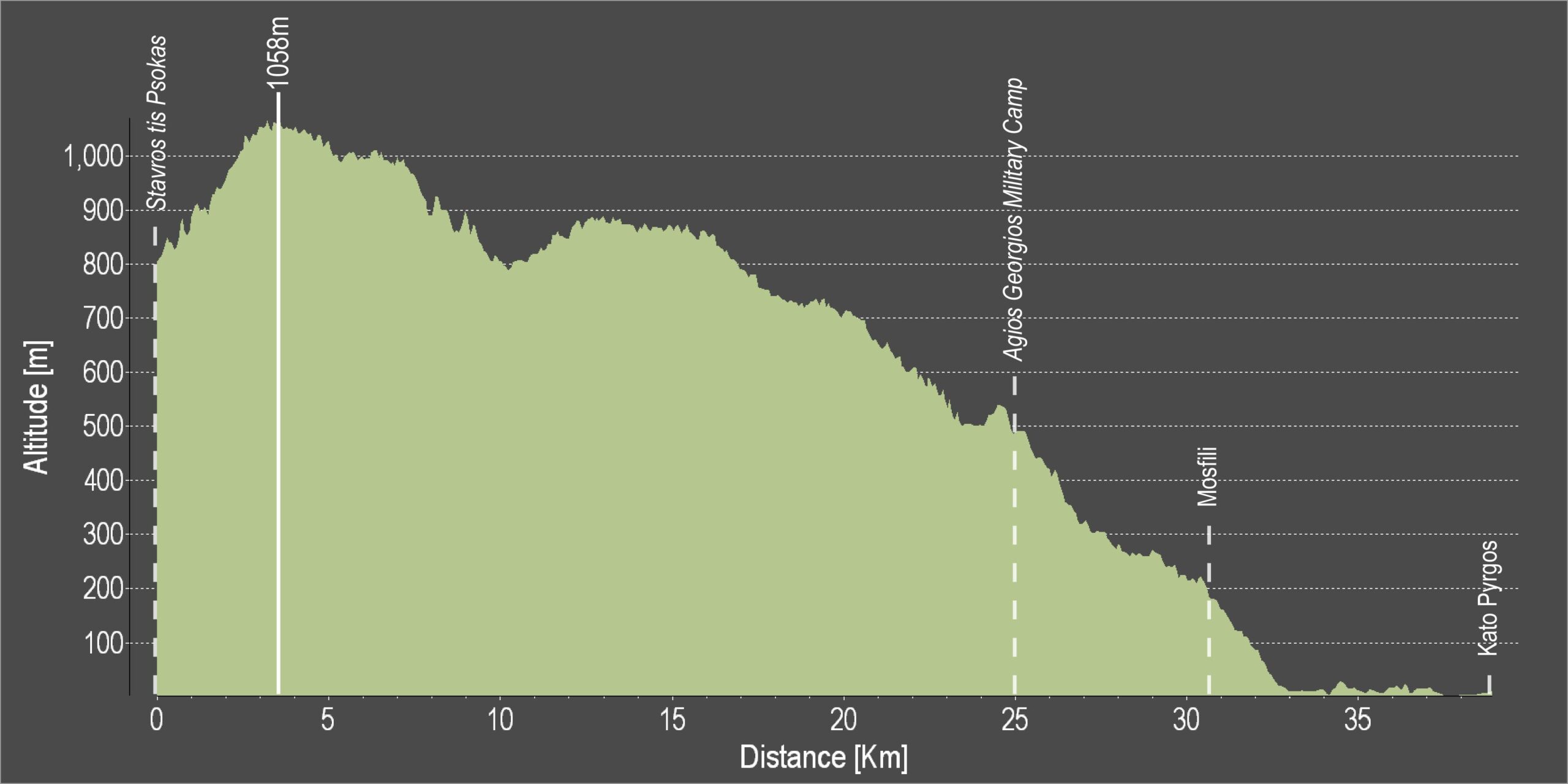
Distance: 39.4km
Elevation Gain: 1575m
Highest point: 1058m
Lowest point: 3m
Loop: NO
Terrain: Mountain
Road surface: Paved
Section Distance (km) Total Distance (km)
Stavros tis Psokas 0,0 0,0
Agios Georgios Military Camp 25,0 25,0
Mosfili 5,7 30,7
Kato Pyrgos 8,7 39,4

Main 14 – Stavros tis Psokas – Panagia – Pafos (Paphos) Cycling Route

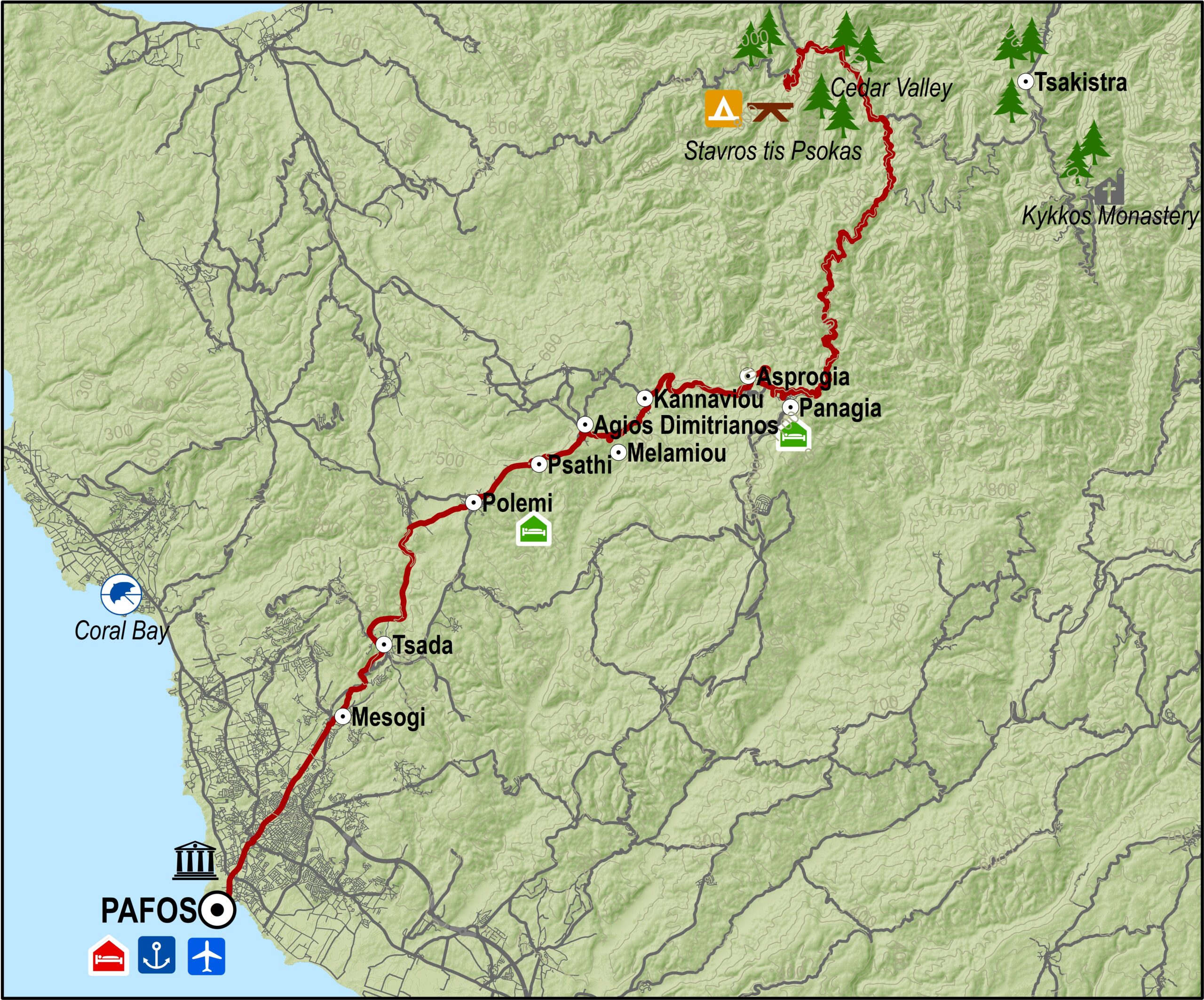
From the forestry station at Stavros tis Psokas, the road then climbs a little further up to the largest village in the area, Panagia, the birthplace of Archbishop Makarios III, the first President of Cyprus. The Monastery of Panagia Chrysorrogiatissa is situated near this village.

The route continues towards Pafos, going through the villages of Asprogia, Kannaviou, Agios Dimitrianos, Psathi, Polemi, Kallepeia, Tsada and Mesogi.

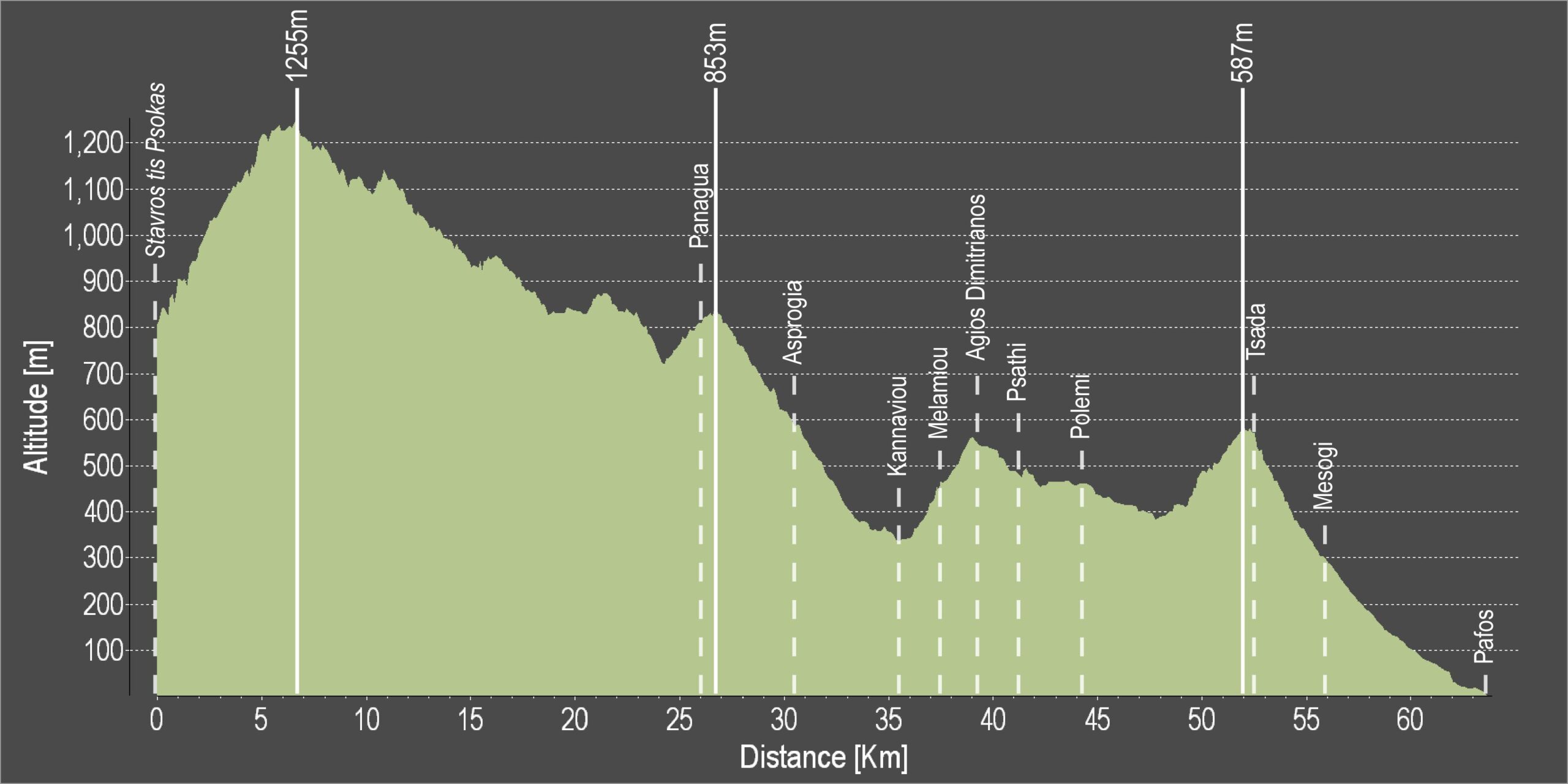
Difficulty rate: Despite being mostly downhill, there are quite a few steep uphills
Road condition: The route is entirely on paved roads.
Route Description: This excursion links the mountainous areas of Troodos and Kykkos with Pafos.

To download the route in gpx format click here

Distance: 64.2km
Elevation Gain: 2251m
Highest point: 1255m
Lowest point: 1m
Loop: NO
Terrain: Mountain
Road surface: Paved
Section Distance (km) Total Distance (km)
Stavros tis Psokas 0,0 0,0
Panagia 26,6 26,6
Asprogia 3,9 30,5
Kannaviou 5,1 35,6
Melamiou 2,0 37,6
Agios Dimitrianos 1,6 39,2
Psathi 1,9 41,1
Polemi 3,1 44,2
Tsada 8,3 52,5
Mesogi 3,5 56,0
Pafos 8,2 64,2

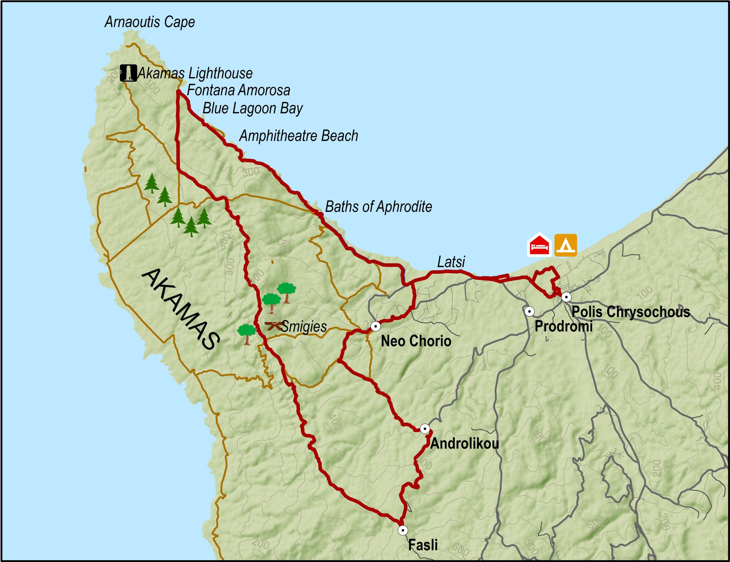
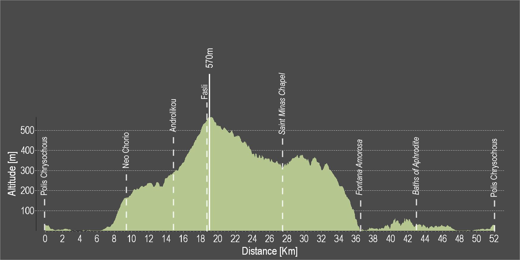
Pafos 4 – Polis – Neo Chorio – Androlikou – Fasli – Fontana Amoroza – Polis Cycling Route

This is one of the most interesting routes in the Pafos area. Starting from Polis Chrysochous and ascending to Neo Chorio, you can enjoy the magnificent views of the coastline. Shortly after, you will find yourself cycling along green pine trees and herds of sheep that graze freely in the area. Further along the route is the, until recently, abandoned village of Androlikou. The dilapidated village houses, will give you the feeling that, here, time has stopped. It is worth stopping to take in the feeling of nostalgia and the strange charm of the abandoned village, before heading up to Drousia.

On the way up to the highest point, you can enjoy the splendid views of the green pine trees stretching downhill to reach the vibrant blue waters of the Mediterranean Sea.

From there on, the route descents to the Fontana Amoroza area. There, before continuing your journey back to Polis Chrysochous, you may enjoy a swim in the beautiful crystal, clear blue waters of the famous Blue lagoon, one of the most beautiful beaches on the island.

To download the route in gpx format click here

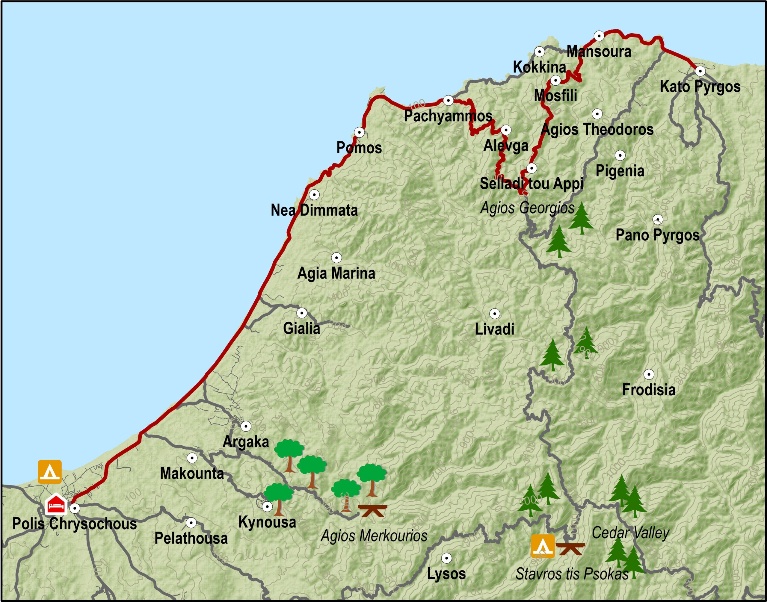
Main 15 – Polis – Pyrgos Cycling Route

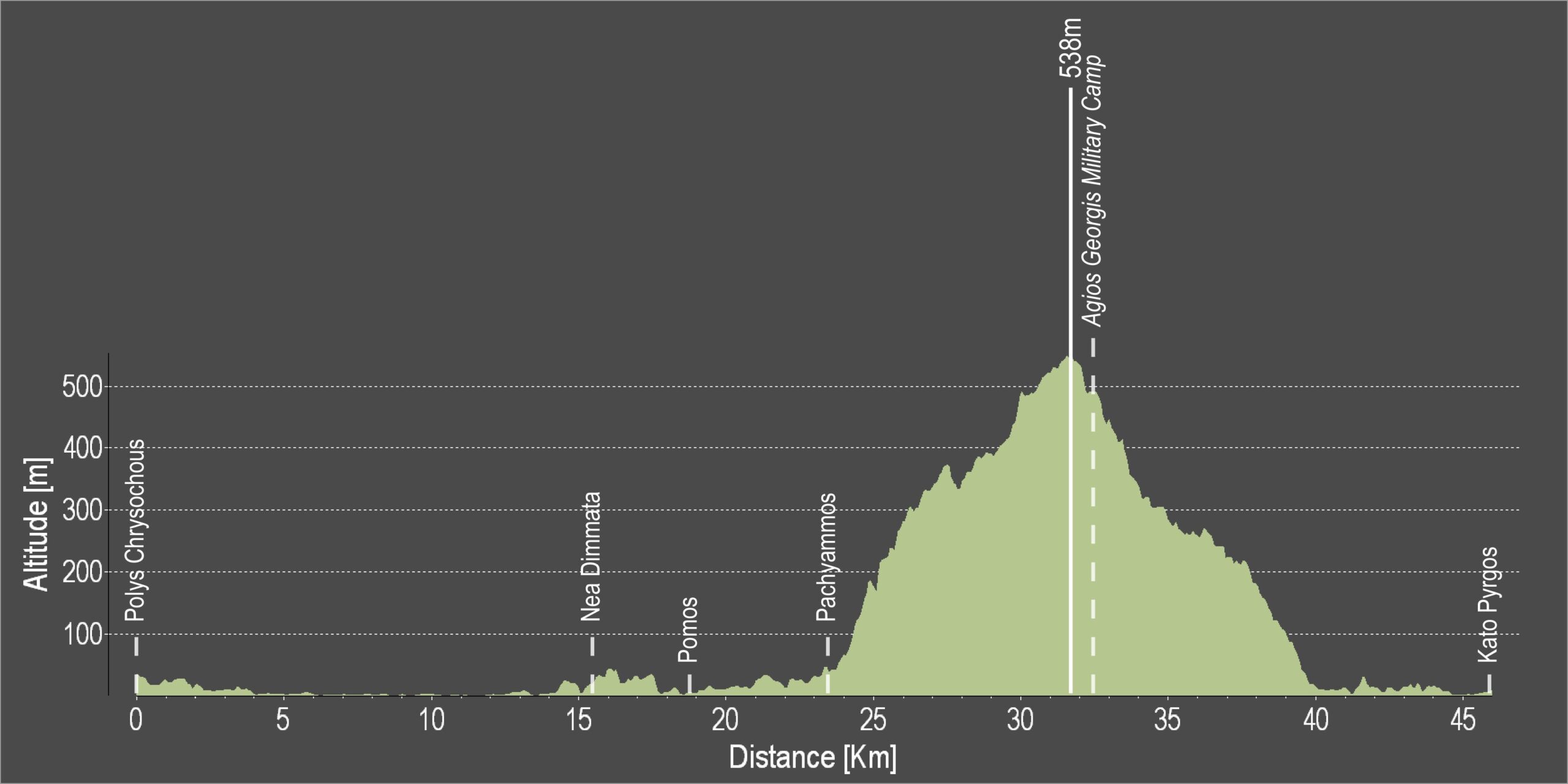
The route begins in Polis and travels along the coast in a northeasterly direction to Pachyammos. It then does a little detour, climbing up into the mountains in a southerly direction in order to by-pass the Turkish enclave of Kokkines, after which it goes downhill to pick up the coastal road again to Pyrgos.

Difficulty rate: Easy and almost flat road with only one uphill past Kokkines. There are often strong onshore winds in the area, particularly in the afternoon. A street bike with at least 20 speeds is required. .
Road condition: Good quality paved roads throughout.
Route Description: This excursion, together with the routes from Pafos, links Pyrgos with Polis and Pafos.

To download the route in gpx format click here

Distance: 46.4km
Elevation Gain: 925m
Highest point: 538m
Lowest point: 1m
Loop: NO
Terrain: Mixed
Road surface: Paved
Section Distance (km) Total Distance (km)
Polis Chrysochous 0,0 0,0
Nea Dimmata 15,4 15,4
Pomos 3,4 18,8
Pachyammos 4,8 23,6
Agios Georgios Military Camp 8,7 32,3
Kato Pyrgos 14,1 46,4

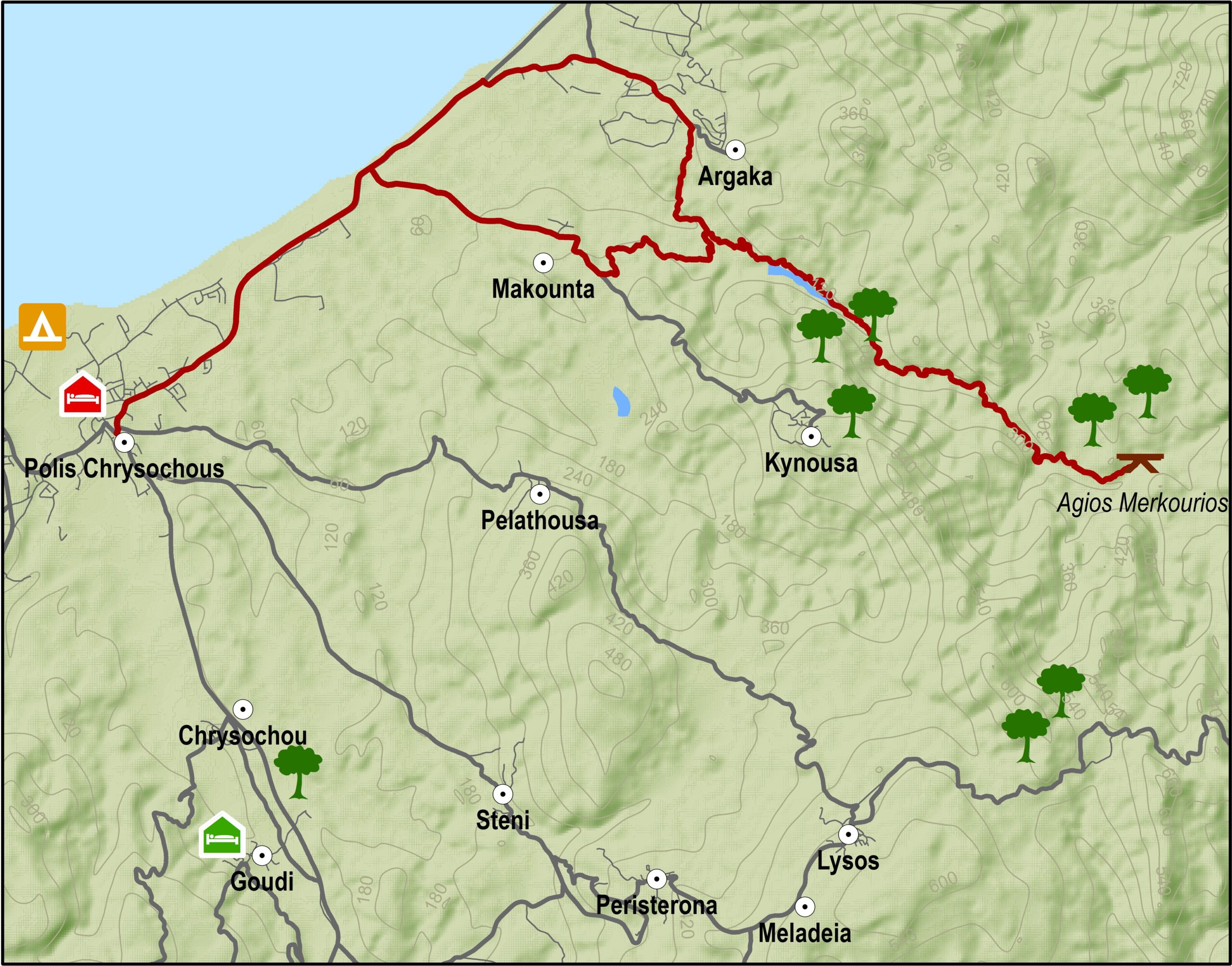
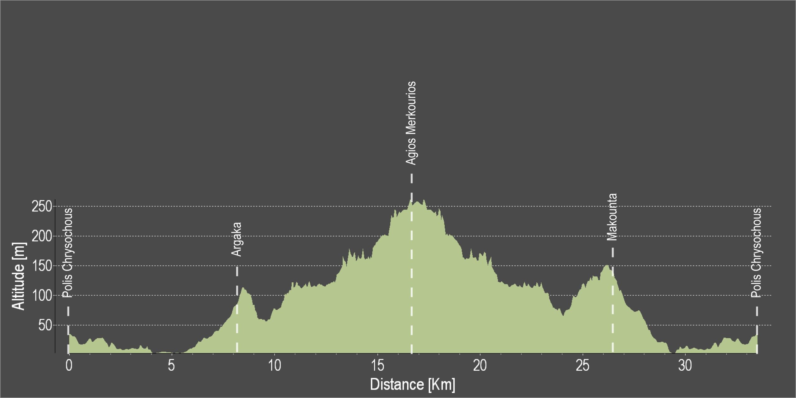
Pafos 5 – Polis – Agios Merkourios – Argaka – Polis Cycling Route

This route goes northeast along the Polis- Pyrgos road. It travels along the coast until a turning to the right leading to the village of Argaka. The road goes past the front of the village school and continues straight and south along a dirt road. It then turns southeast to the picnic site at Agios Merkourios. From there it goes along a descending forest road to Argaka and Makounta and back to Polis.

Difficulty rate: A relatively easy route, despite being on a dirt road.
It requires a mountain bike with front suspension.
Road condition: A variety of surfaces.

To download the route in gpx format click here

Distance: 32.9km
Elevation Gain: 653m
Highest point: 254m
Lowest point: 5m
Loop: YES
Terrain: MIxed
Road surface: Mixed
Section Distance (km) Total Distance (km)
Polis Chrysochous 0,0 0,0
Argaka 8,1 8,1
Ag. Merkourios 8,6 16,7
Makounta 9,8 26,5
Polis Chrysochous 6,4 32,9

Polis – Akamas Lighthouse Cycling Route

The greatest advantage of cycling in the Polis area is its proximity to the Akamas Peninsula.

This 22km route begins in Polis and heads west towards Lakki (Latsi), the small harbour / marina of Polis and the Baths of Aphrodite. Shortly after Lakki (Latsi) ­ and just before the Baths it turns south ­ climbing towards Neo Chorio. The route travels through the village and then heads west with the road becoming a dirt road just outside the village. It then passes Smigies picnic site, which is the last stop for water. From Smigies, the route climbs rather steeply and turns right, heading southwest along the slopes of a hill offering alternating views of the east and west sides of the peninsula. A turning to the right, 3km from Smigies, leads to ruins known as Pyrgos tis Rigainas.

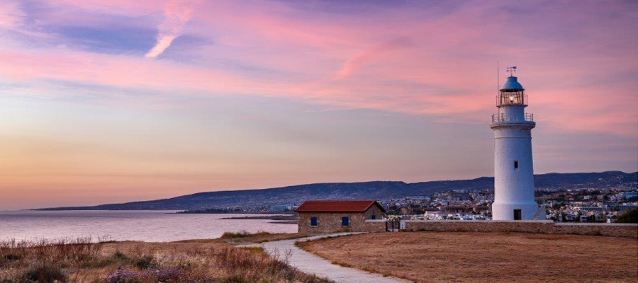
Alternatively, continuing straight for another 2km leads on to the road to Lara, Fontana Amorosa and the Baths of Aphrodite. Further along this road is Akamas lighthouse. Alternative route: You can return to Polis from the lighthouse by going along the Fontana Amorosa road to the Baths of Aphrodite.

Start Point: Polis
End Point: Akamas Lighthouse
Total Distance: 22km
Difficulty Rating: A difficult route. Requires a mountain bike with at least 21 speeds. Front fork suspension is recommended.
Road Conditions: A variety of surfaces.