Main 16 – Pafos (Paphos) – Pegeia – Polis Cycling Route

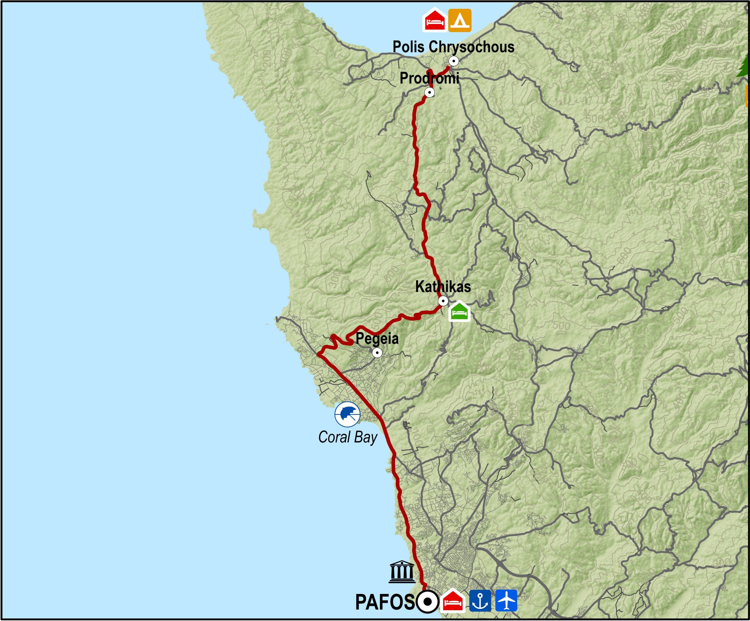
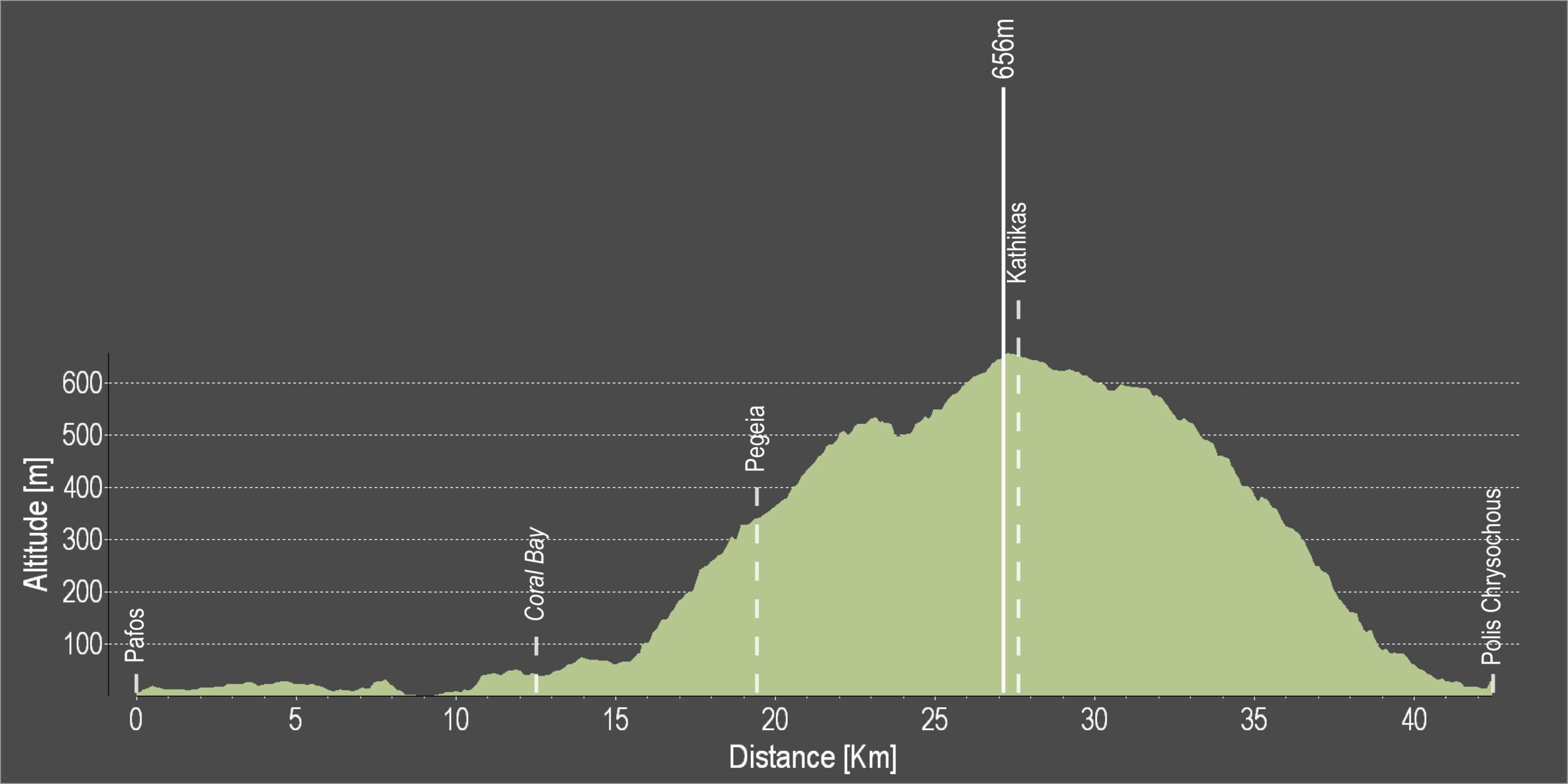
The route begins in Kato Pafos and goes along the coastal road in a northwesterly direction until the crossroads at Coral Bay, where it turns right. It then climbs to Pegeia, known for its fountain.
The route continues climbing through the village, which offers a spectacular view of the west coast. It then enters the forest and travels northeast to the village of Kathikas from where it heads north to Prodromi and finally to Polis.

Difficulty rate: A rather tough route for the average cyclist but can be achieved with some effort and on a good road bike with 20 speeds.
Road condition: Good quality paved roads throughout
Route Description: This route goes from Pafos to Polis, the main town of the Chrysochou bay.

To download the route in gpx format click here

Distance: 43.8km
Elevation Gain: 775m
Highest point: 656m
Lowest point: 4m
Loop: NO
Terrain: Mixed
Road surface: Paved
Section Distance (km) Total Distance (km)
Pafos 0,0 0,0
Coral Bay 12,4 12,4
Pegeia 7,2 19,6
Kathikas 7,7 27,3
Prodromi 16,0 43,3
Polis Chrysochous 0,5 43,8

Pafos 3 – Pafos (Paphos) – Ag.Georgios – Lara – Fontana Amorosa – Baths of Aphrodite Cycling Route

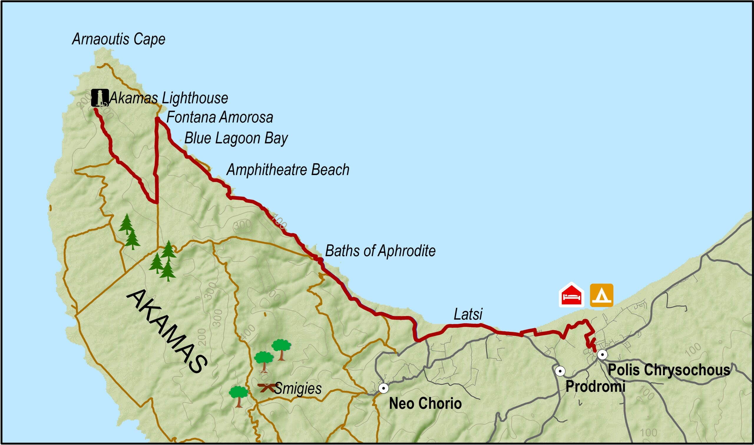
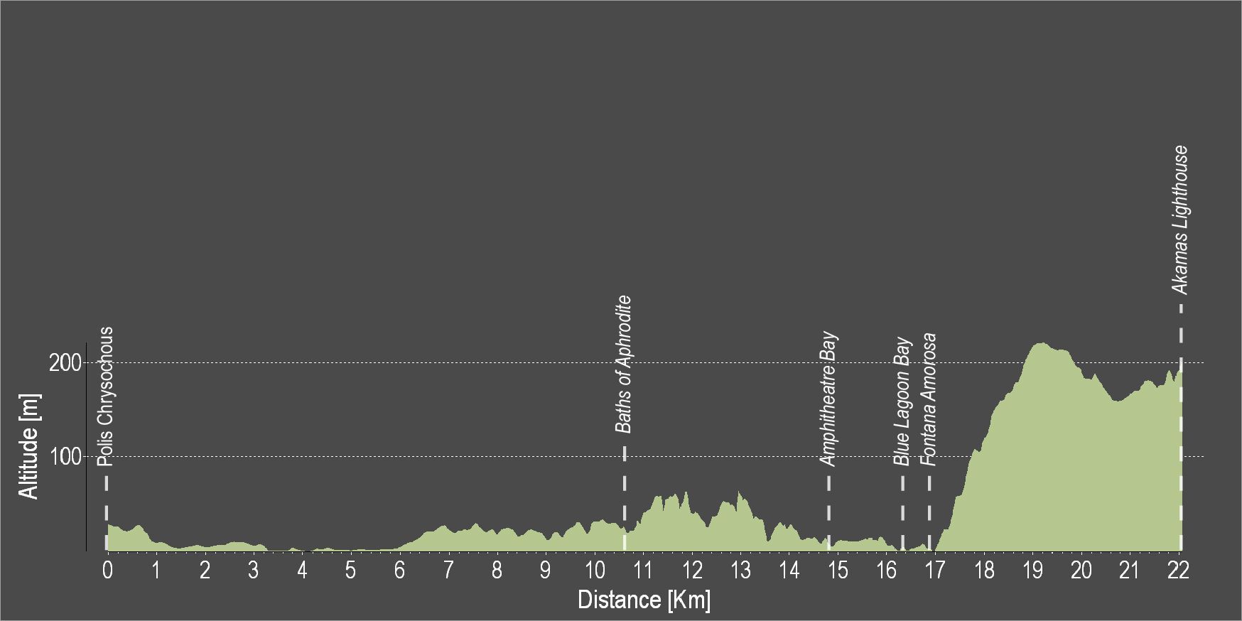
The route starts at Polis Chrysochous and it does not take long to reach the famous fresh water spring Loutra tis Afroditis (Baths of Aphrodite), where, according to legend, the Goddess of Love and Beauty used to take her baths. Both the spring itself, as well as the adjacent botanical garden are worth visiting.

Continuing your ride through the forest of the Akamas peninsula, on your way up toward the Akamas lighthouse, you will enjoy magnificent views of the westernmost cape of Cyprus. Right before the beginning of the big uphill (17 km from the start point), in the Fontana Amoroza area, you may enjoy a swim in the beautiful crystal, clear blue waters of the famous Blue lagoon, one of the most beautiful beaches on the island.

Once you arrive at ‘Faros’, the Akamas lighthouse, and after enjoying the view, you can return to Polis Chrysochous following the same route back.

Alternatively, if you still have the strength, you can continue ascending to the ‘Smiges’ picnic area and continue through Neo Chorio village and all the way back to Polis Chrysochous.

To download the route in gpx format click here

Pafos 2 – Kato Pafos (Paphos) – Timi Forest Cycling Route

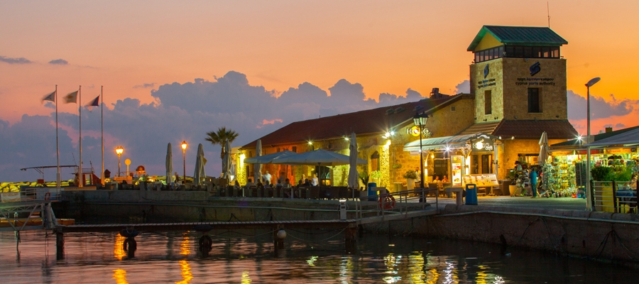
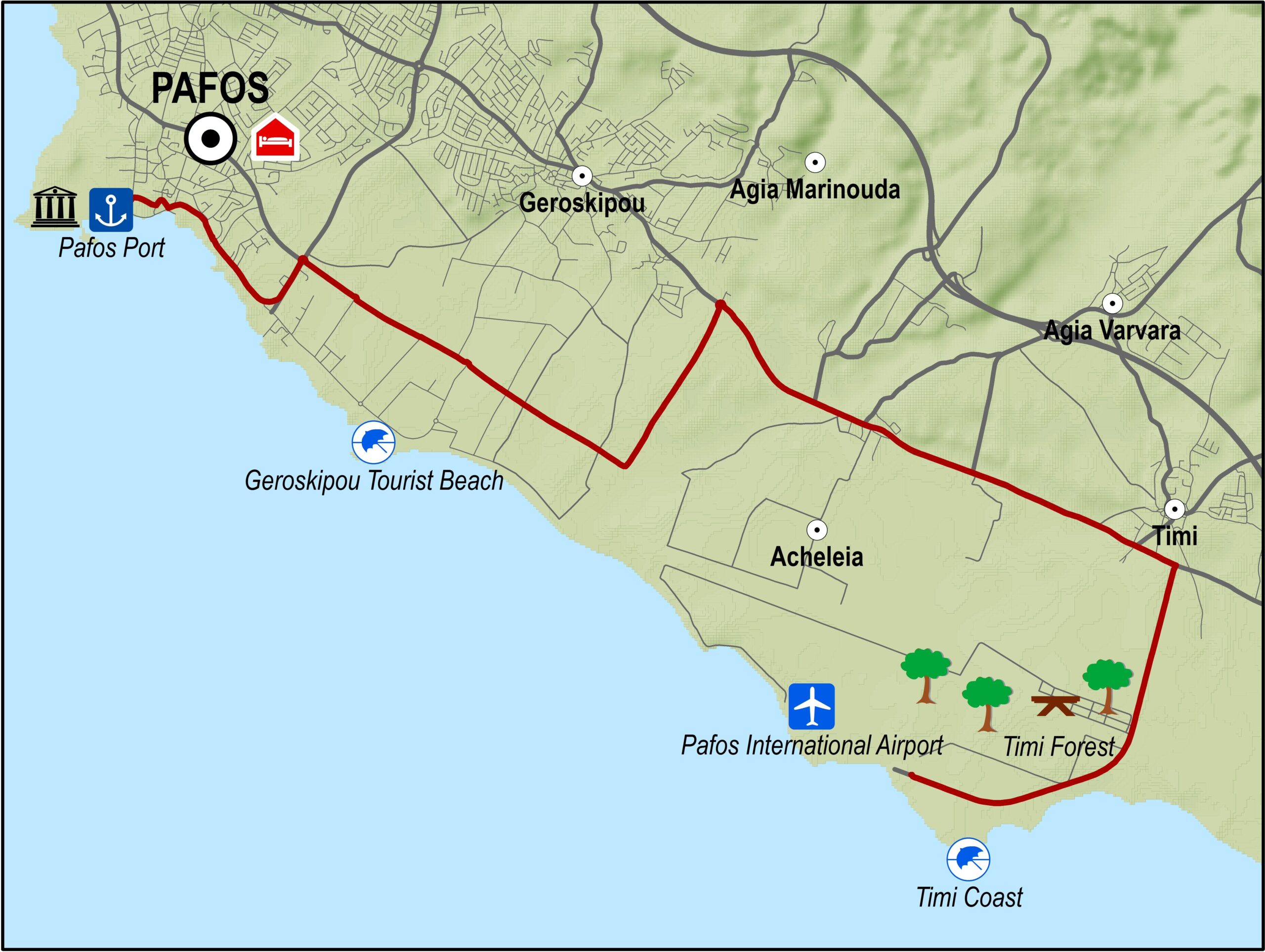
This excursion is actually a bicycle tour of the Pafos (Paphos) area. It goes along the coastal front of Kato Pafos, past the Geroskipou Tourist Beach and ends at Timi beach next to Pafos airport and the nearby eucalyptus grove.

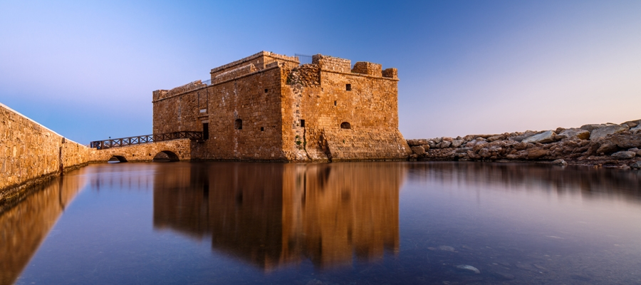
The route starts off at Pafos harbour and heads in a southeasterly direction, travelling along the coast. From there it goes along the old Pafos – Limassol road up to the Pafos airport. At that point the route turns right towards the sea and Pafos airport, a bit further down reaches the small bay and beach of Timi and the eucalyptus grove with its picnic site.

Difficulty rate: A touring bike or road bike is required.
Road condition: Entirely on paved roads.

To download the route in gpx format click here

Distance: 16.6km
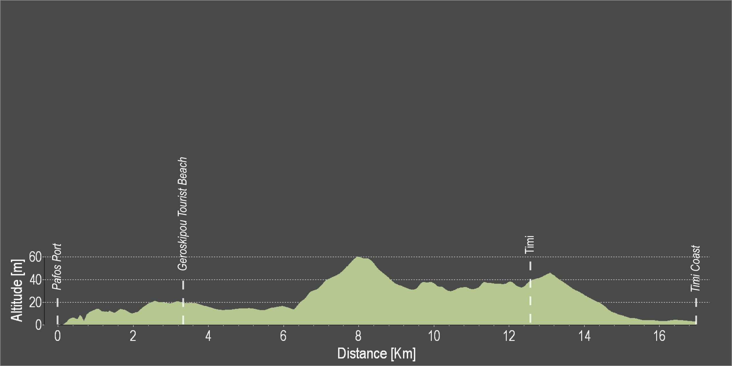
Elevation Gain: 76m
Highest point: 59m
Lowest point: 3m
Loop: NO
Terrain: Flat
Road surface: Paved
Section Distance (km) Total Distance (km)
Pafos Port 0,0 0,0
Geroskipou Tourist Beach 3,4 3,4
Timi 8,9 12,3
Timi Coast 4,3 16,6

Pafos 1 – Pafos Castle – Agia Varvara – Episkopi – Tsada – Armou- Agia varvara – Pafos Castle Cycling Route

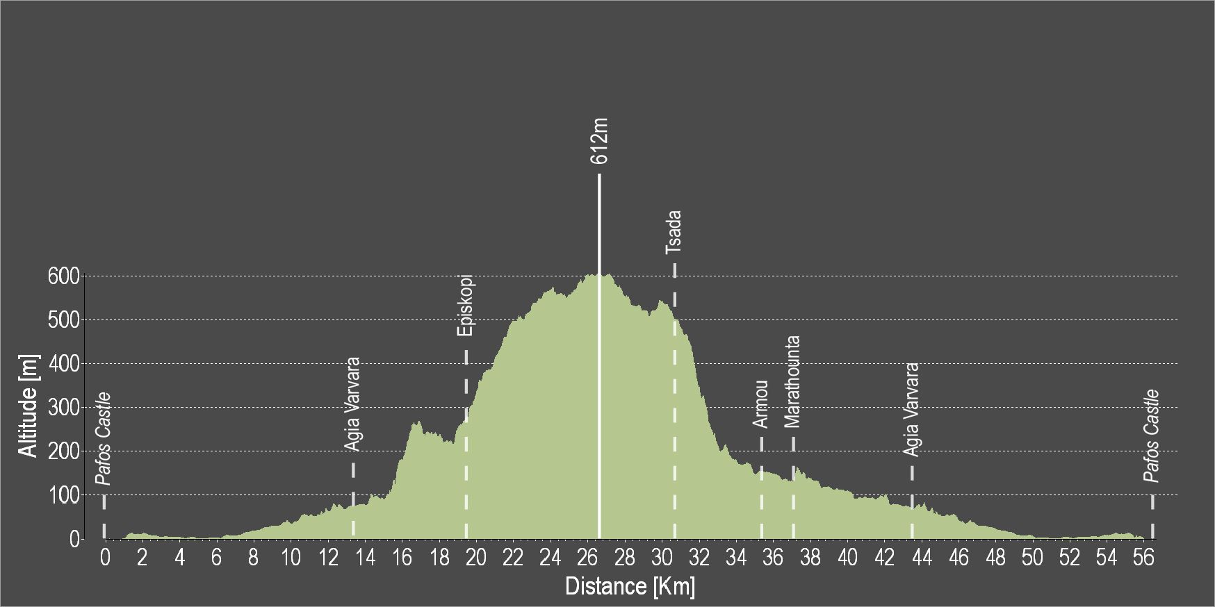
Starting your ride at Pafos town, you will soon leave the city noise behind you and you will find yourself riding along orange and lemon tree groves! The route continues through Agia Varvara all the way to Episkopi village. There are excellent views along the way but the most impressive view is from the “Rock” on which the village church devoted Saint Ilarion the Great, is built. From this point, you can enjoy uninterrupted views of the Ezousa Valley below as well as taking in the beauty of nature itself. The Ezousa Valley is one of the most beautiful valleys of Cyprus. Due to its high ecological value, it has been included in the European network of protected areas NATURA 2000.

In Episkopi you can also visit the Environmental Information Centre.

Moving on, you will ascend to the highest point of the area. From this particular point, visibility extends to the Pafos forest and the mountain range of Troodos.

The return route is easier as it is mostly downhill.

To download the route in gpx format click here

Main 10 – Pitsylia – Troodos Cycling Route

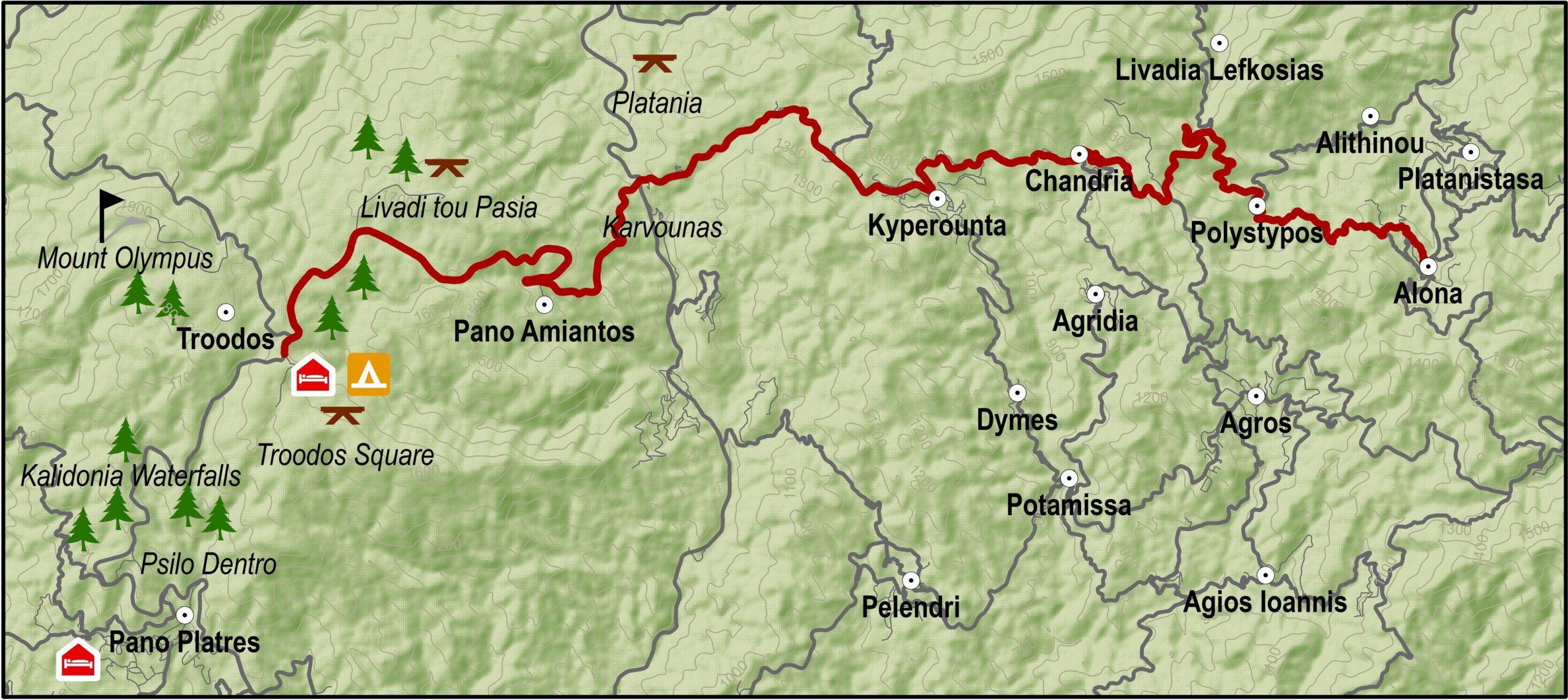
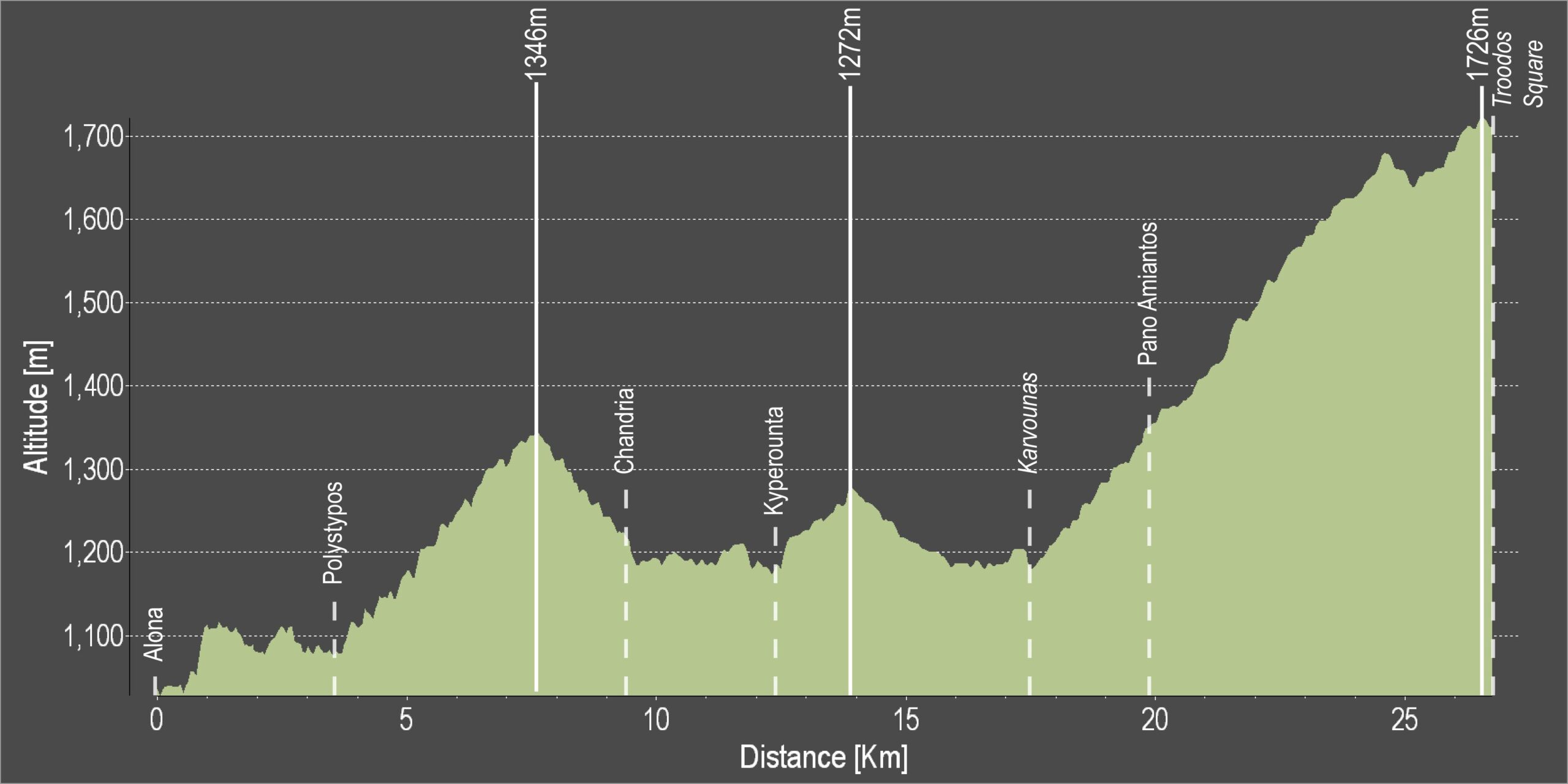
From Alona the route heads southwest, goes through Polystypos and climbs to the northwest, passing underneath the Madari peak and reaching Chandria village.

At Chandria it turns right and heads west, through Kyperounta to reach the crossroads at Karvounas. From Karvounas it heads south climbing steeply towards Pano Amiantos and then heads west climbing even more steeply to Troodos square. Before reaching the square it goes past the picnic sites of Almyrolivado and Livadi tou Pasa as well as a camping and a picnic site just before the square.

Difficulty rate: Quite a difficult course. It requires a road bike with low/ easy gear ratios.
Road condition: Paved roads throughout.
Route Description: This route connects the areas of Pitsylia and Troodos. It is an interesting route for visiting the surrounding villages.

To download the route in gpx format click here

Distance: 26.3km
Elevation Gain: 1434m
Highest point: 1726m
Lowest point: 1046m
Loop: NO
Terrain: Mountain
Road surface: Paved
Section Distance (km) Total Distance (km)
Alona 0,0 0,0
Polystypos 3,5 3,5
Chandria 5,8 9,3
Kyperounta 3,0 12,3
Karvounas 5,0 17,3
Pano Amiantos 2,6 19,9
Troodos Square 6,4 26,3

Lemesos 3 – Lemesos – Fasouri – Pachna – Lemesos Cycling Route

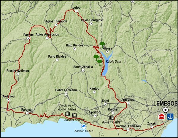
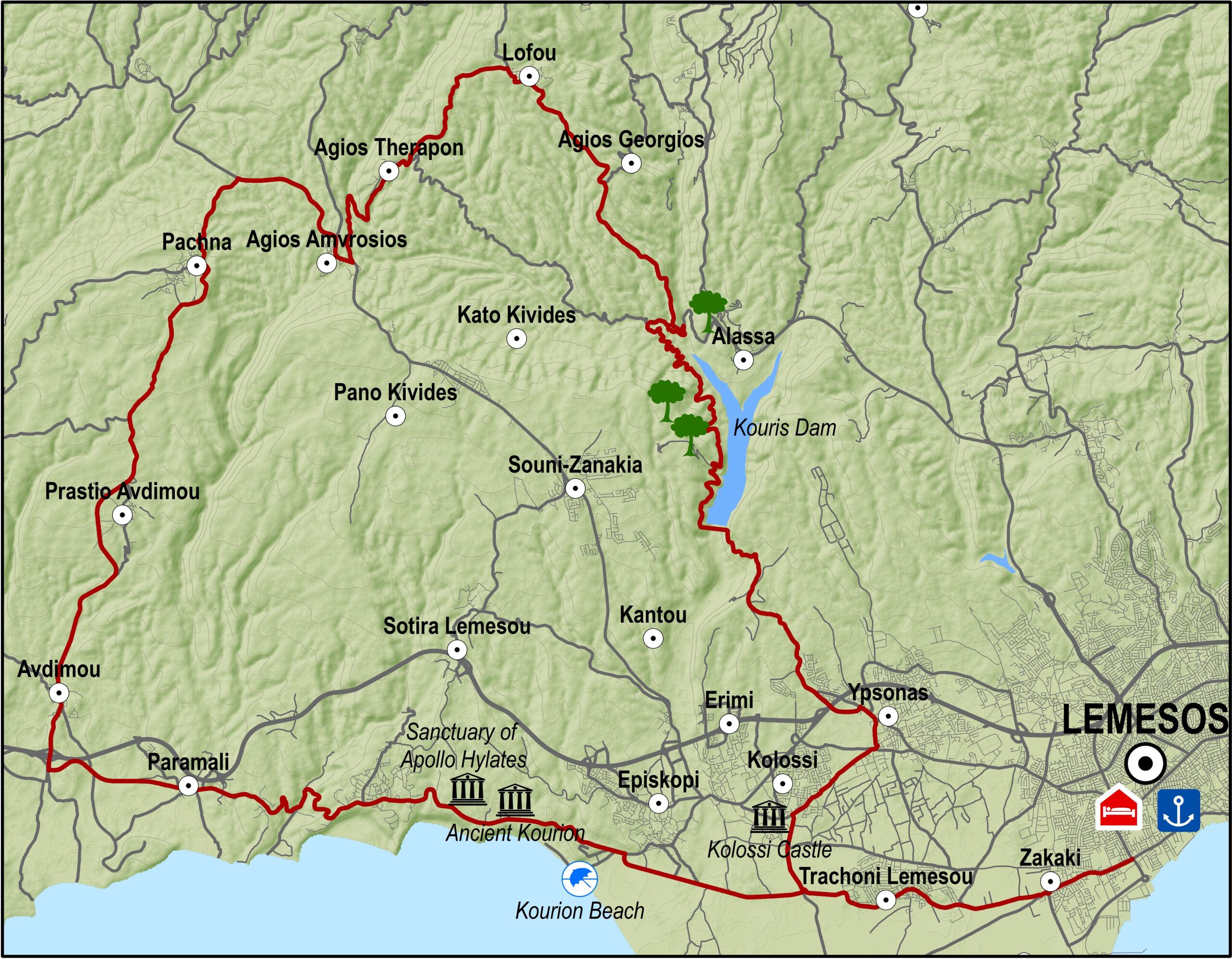
The excursion goes through the western villages of the Lemesos district. It travels past traditional wine-producing villages, goes along the picturesque Fasouri road where the cypress trees growing on either side form a canopy of leaves overhead, and drives past important archaeological sites like that of Kourion.

From the Lemesos port traffic lights, the route heads west towards Zakaki. For about 15km the landscape consists of citrus orchards. Asomatos village and Fasouri settlement are the main orange- producing areas of Lemesos. Along the old Lemesos-Pafos road, the route goes past the chapel of Agios Ermogenis, the entrance to the archaeological site of Kourion and the popular Kourion beach.It then climbs steeply for about 1km and arrives at the Ancient Stadium of Kourion and the Sanctuary of Apollo Ylatis.

Next, the route goes past the military base of Episkopi and the village of Paramali, where it starts to climb to the north towards Avdimou and Prastio until it reaches Pachna, the main wine-producing village of the region.The village is full of vineyards, as are the following villages of Agios Amvrosios and Kivides, which are smaller in size and population.

After Kivides the route is downhill and offers a spectacular view to the east of the town and bay of Lemesos spread out below in all its glory as well as the Akrotiri peninsula and the bay of Episkopi. The straight road that leads to Souni and Kantou is relaxing and enables one to enjoy the countryside. Shortly after Kantou is Erimi, a village located on the old Lemesos – Pafos road.From there the route turns left in an easterly direction, and then right to Kolossi and its medieval castle. The return journey to Lemesos is via Fasouri.

Difficulty rate: It is a relatively long route but it does not present any particular difficulty except for a few steep uphills, which require a bicycle with speeds.
Road condition: Good quality, paved roads throughout.

To download the route in gpx format click here

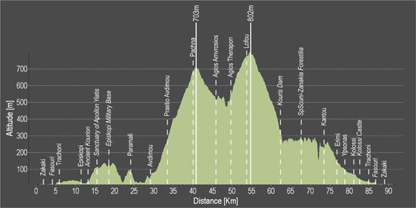
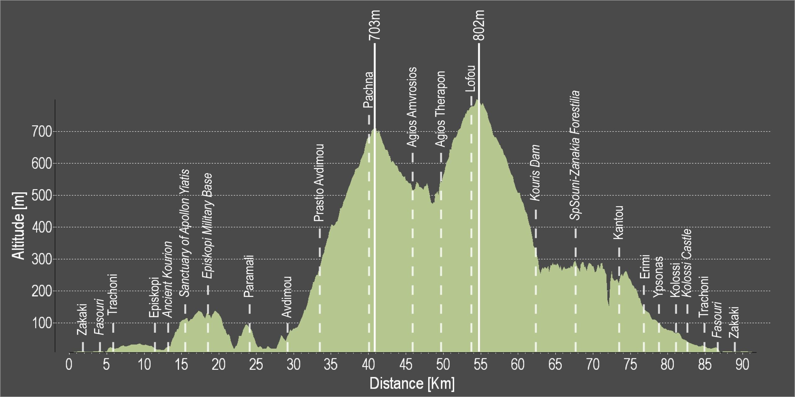
Distance: 90.8km
Elevation Gain: 1878m
Highest point: 802m
Lowest point: 3m
Loop: YES
Terrain: Mountain
Road surface: Paved
Section Distance (km) Total Distance (km)
Port traffic lights 0,0 0,0
Zakaki 1,8 1,8
Fasouri 2,2 4,0
Trachoni 1,7 5,7
Episkopi 6,3 12,0
Ancient Kourion 0,3 12,3
Sanctuary of Apollon Ylatis 3 15,3
Episkopi Military Base 3,2 18,5
Paramali 5,5 24,0
Avdimou 5 29,0
Prastio Avdimou 4,6 33,6
Pachna 6,6 40,2
Agios Amvrosios 5,7 45,9
Agios Therapon 3,8 49,7
Lofou 4,8 54,5
Kouris Dam 7,8 62,3
Souni-Zanakia Forest 5,4 67,7
Kantou 5,8 73,5
Erimi 3,5 77,0
Ypsonas 1,6 78,6
Kolossi 2,7 81,3
Kolossi Castle 0,8 82,1
Trachoni 3 85,1
Fasouti 1,7 86,8
Zakaki 2,2 89,0
Port traffic lights 1,8 90,8

Lemesos 1 – Lemesos (Limassol) – Ancient Amathous Cycling Route

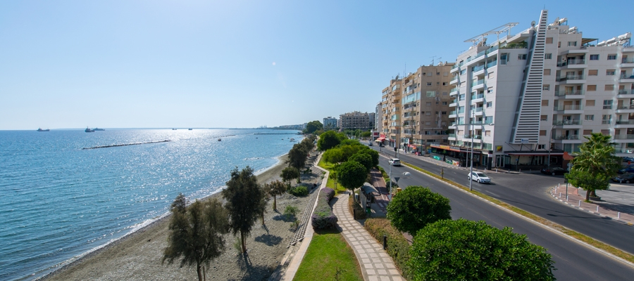
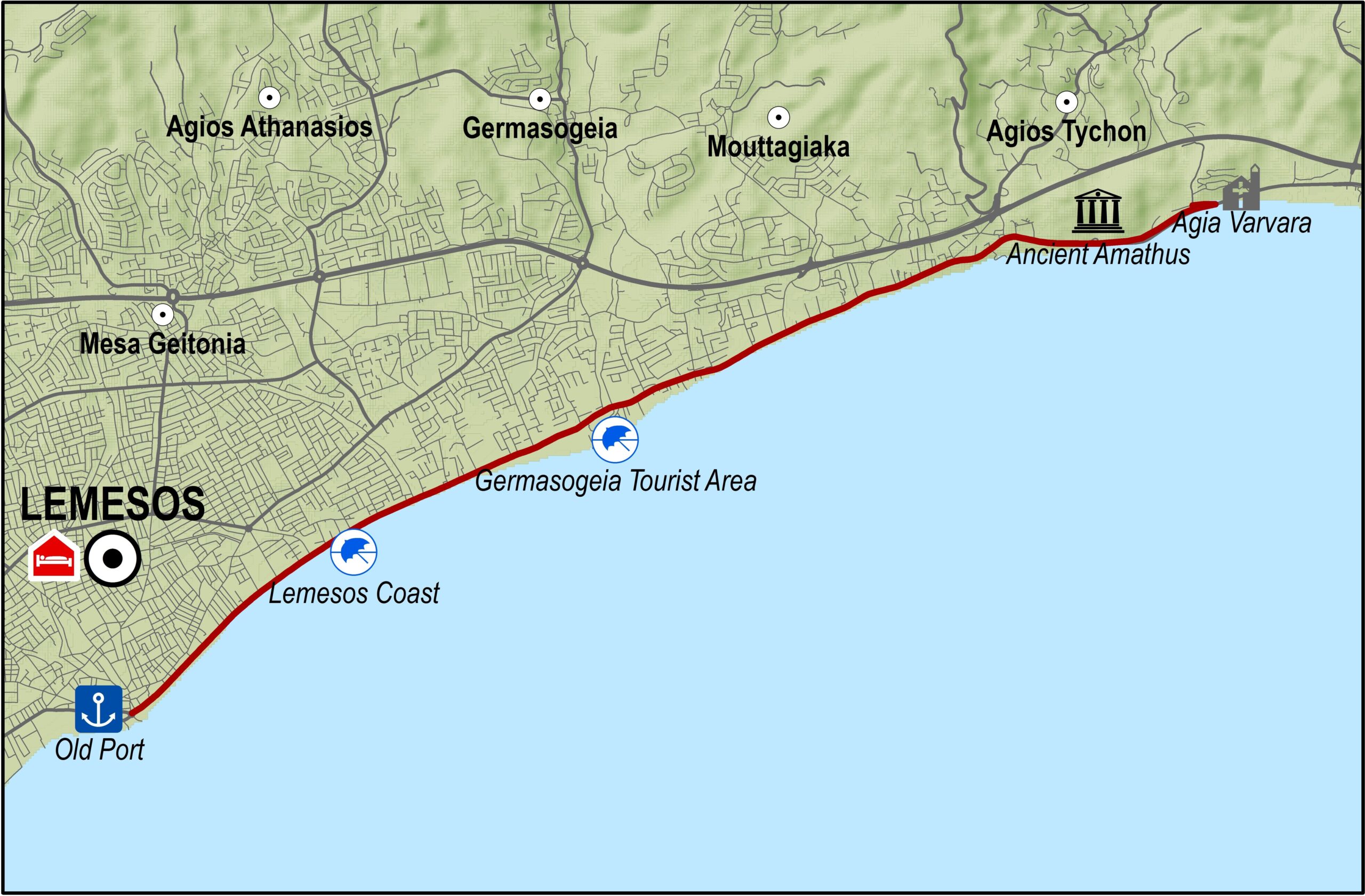
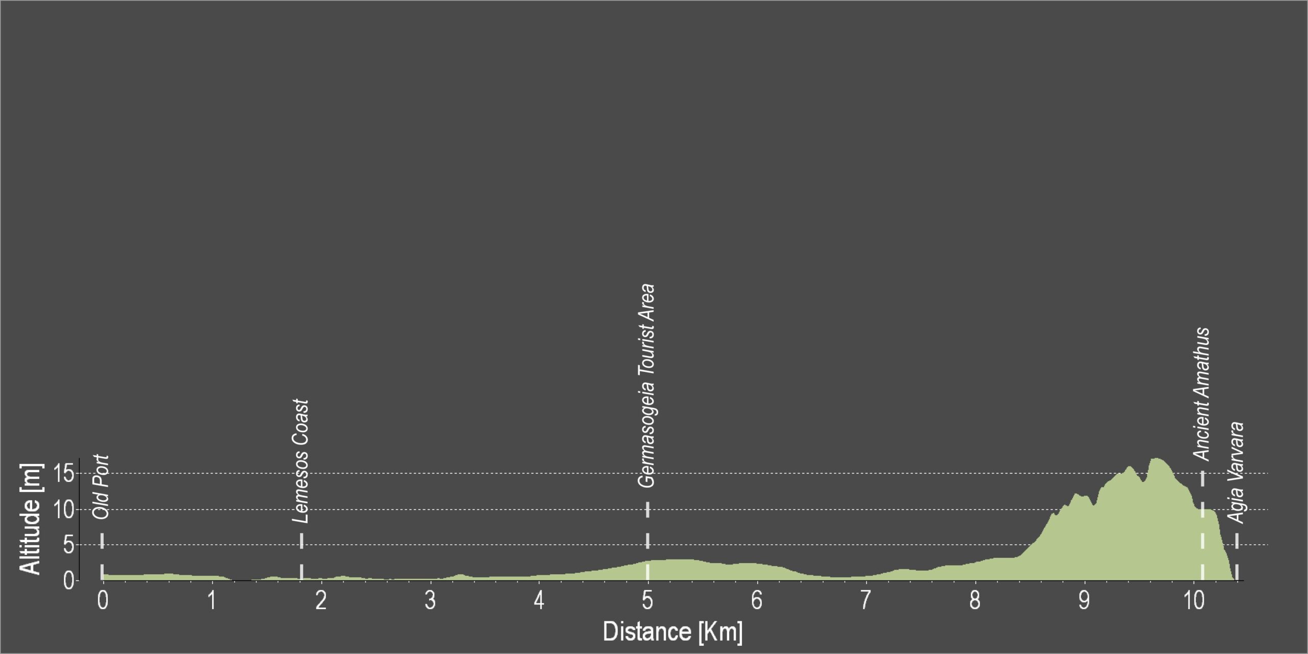
The route begins from the old port of Lemesos and heads northeast along the coast. It goes through the tourist area of Germasogeia with its many shops, nightclubs, restaurants, hotels and traditional tavernas. The route ends at the archaeological site of Amathous. A short distance down the road is the old chapel of Agia Varvara, once a favourite spot for local fishermen. Just opposite the chapel there is a beautiful eucalyptus grove that provides plenty of shade for swimmers.

Difficulty rate: An easy ride for all types of bicycles.
Road condition: Entirely paved.
Route description: This route is a bicycle tour of Lemesos. There are very few variations in level and are not worth mentioning. It takes cyclists through the tourist area of Germasogeia, ancient Amathous and the nearby chapel of Agia Varvara with its eucalyptus grove and its lovely beach.

To download the route in gpx format click here

Distance: 9.9km
Elevation Gain: 45m
Highest point: 24m
Lowest point: 2m
Loop: NO
Terrain: Flat
Road surface: Paved
Section Distance (km) Total Distance (km)
Old Port 0,0 0,0
Lemesos Coast 1,8 1,8
Germasogeia Tourist Area 3,3 5,1
Ancient Amathus 5,2 10,3
Agia Varvara 0,9 11,2

Lemesos 4 – Germasogeia – Kalo Chorio – Polemidia Cycling Route

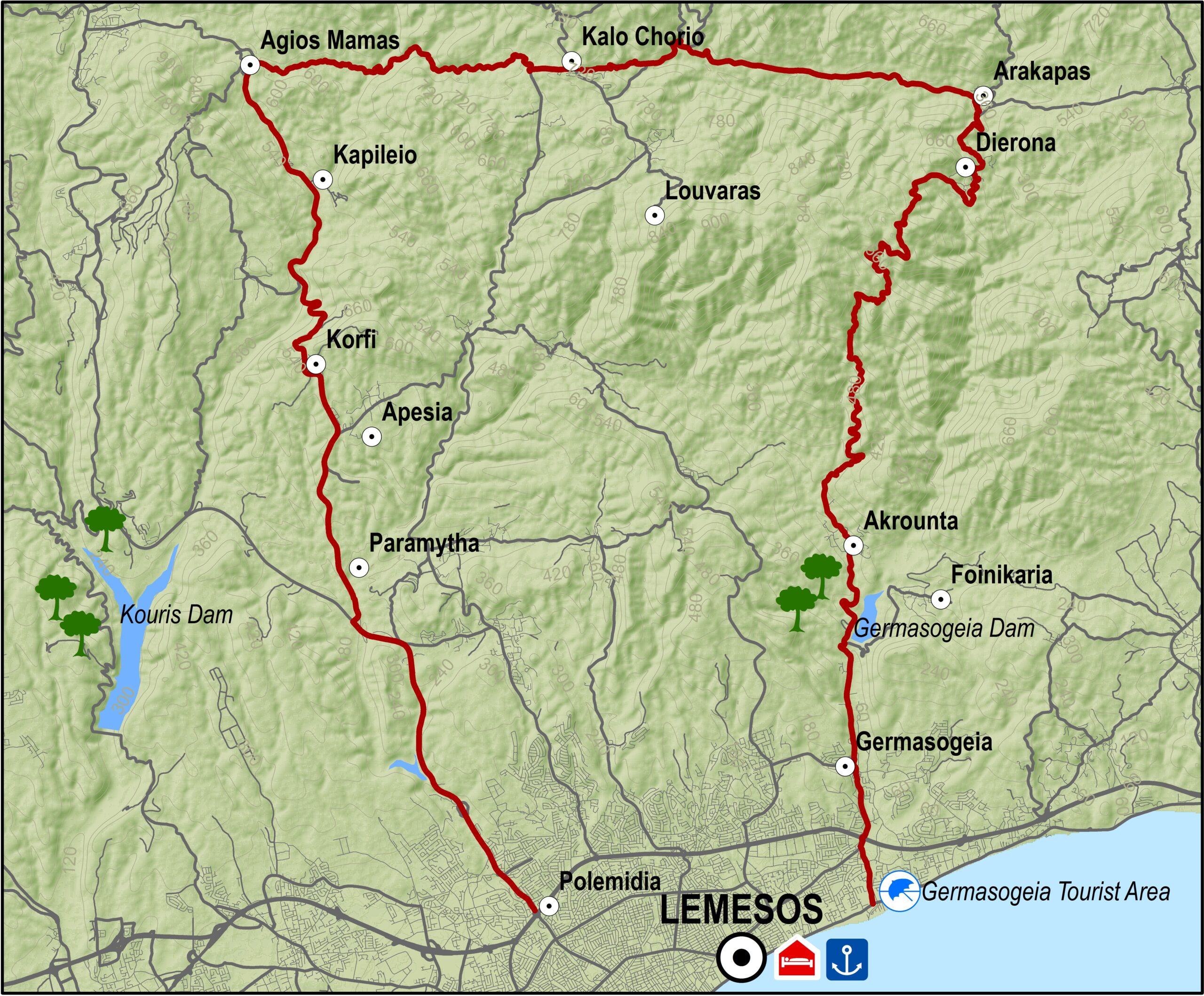
This excursion goes through the eastern villages of the Lemesos (Limassol) district as well as some of the mountain villages in the foothills of the Pitsylia region, such as Agros. You can also go down towards Palaichori along theroutes of the Lefkosia (Nicosia) district. The route heads north starting at the Germasogeia roundabout. It climbs through the village, goes past the Germasogeia dam and the villages of Akrounta, Dierona and Arakapas.

At Arakapas, the route turns west and continues climbing steadily to the village of Kalo Chorio where it meets the Lemesos – Pitsylia road. Heading in the direction of Lemesos, a short distance down the road and to the right, is the dirt road that leads to Agios Mamas. From Agios Mamas the route begins to descend along a paved road passing through the villages of Kapileio and Korfi to reach the roundabout of Polemidia on the outskirts of Lemesos.

Difficulty rate: Average.It requires a road bike with at least 20 speeds.
Road condition: Entirely paved roads.

To download the route in gpx format click here

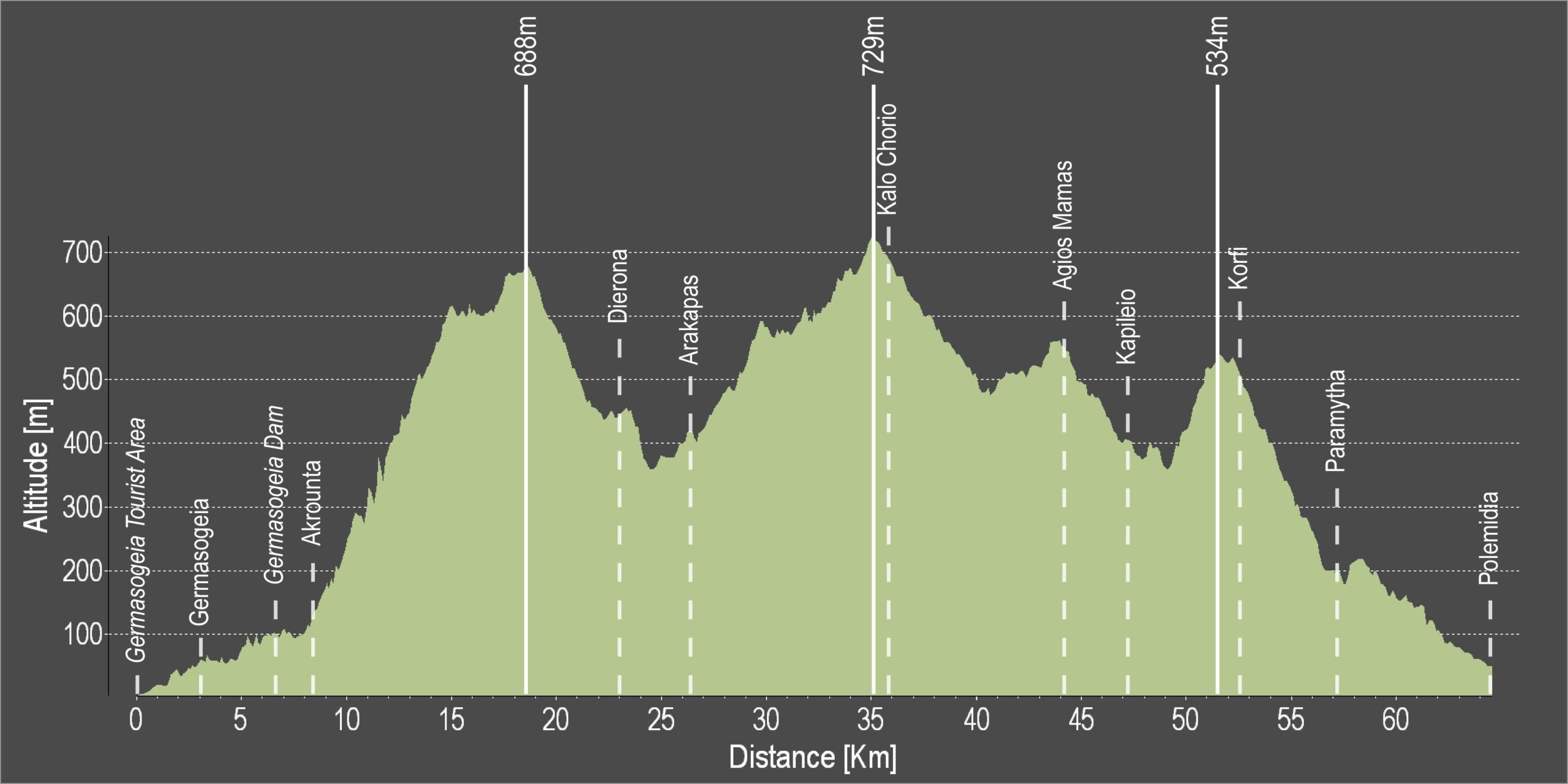
Distance: 65.9km
Elevation Gain: 2007m
Highest point: 729m
Lowest point: 7m
Loop: NO
Terrain: Mountain
Road surface: Paved
Section Distance (km) Total Distance (km)
Germasogeia Tourist Area 0,0 0,0
Germasogeia 3,0 3,0
Germasogeia Dam 3,6 6,6
Akrounta 1,7 8,3
Dierona 15,6 23,9
Arakapas 2,3 26,2
Kalo Chorio 9,5 35,7
Agios Mamas 8,4 44,1
Kapileio 3,1 47,2
Korfi 5,4 52,6
Paramytha 4,6 57,2
Polemidia 8,7 65,9

Lemesos 2 – Ancient Amathous – Governor’s Beach Cycling Route

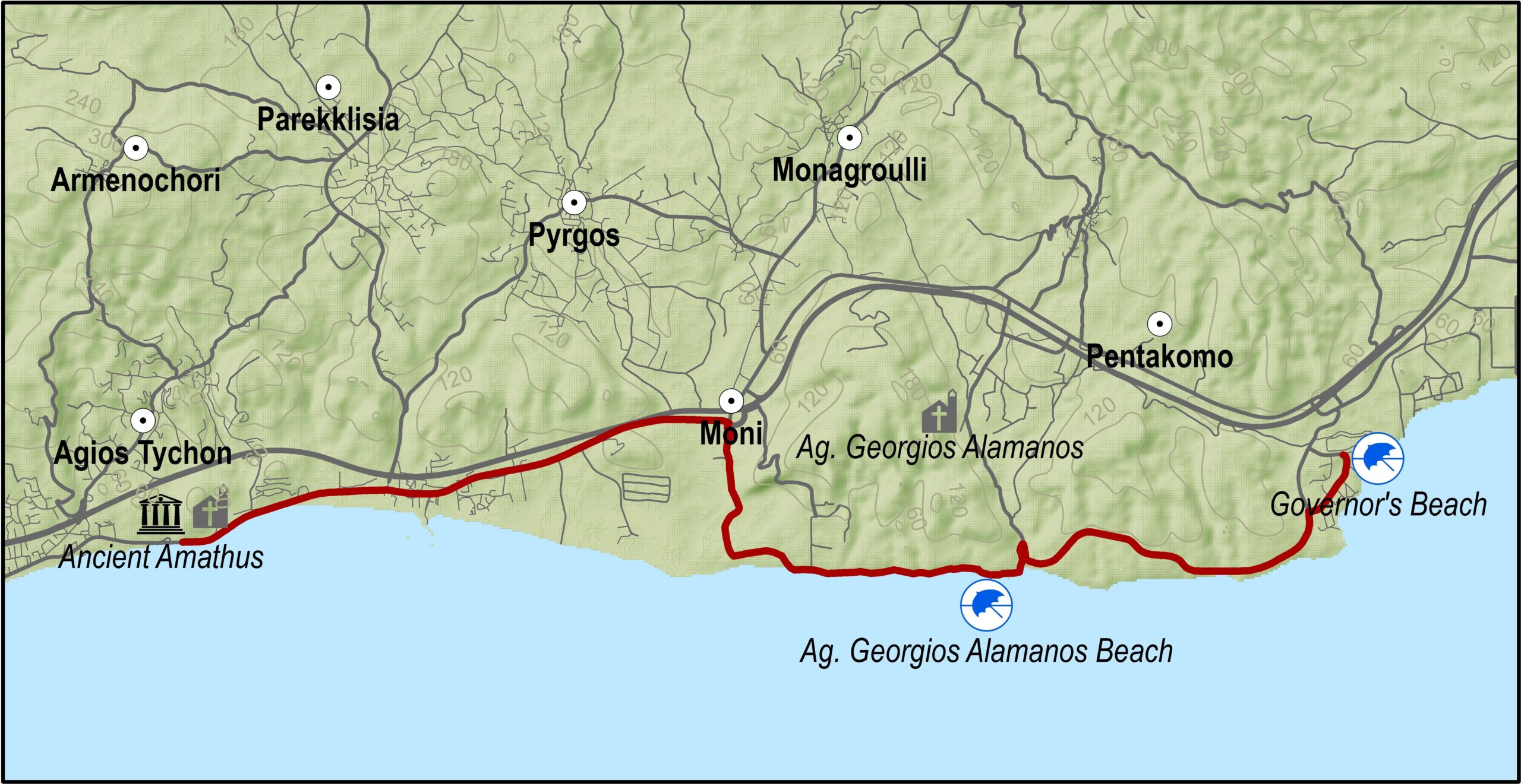
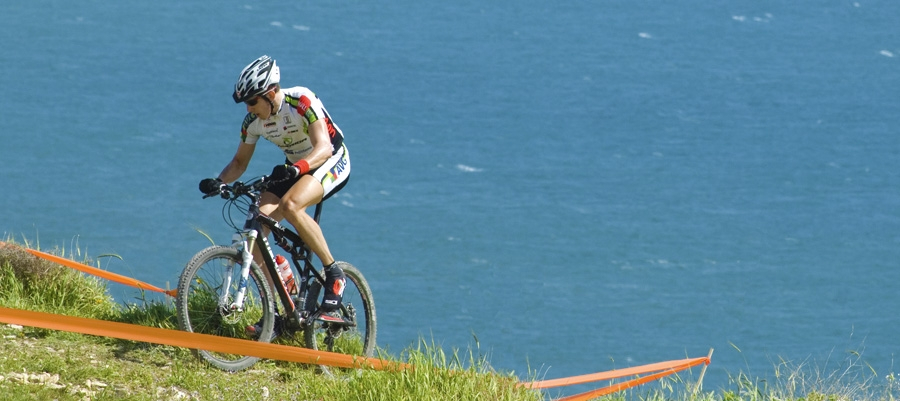
This excursion is for mountain bike fanatics who will appreciate the technical difficulties involved. Although there are few level changes, the fact that a large part is on rocky ground calls for a good sense of balance and technical skills.

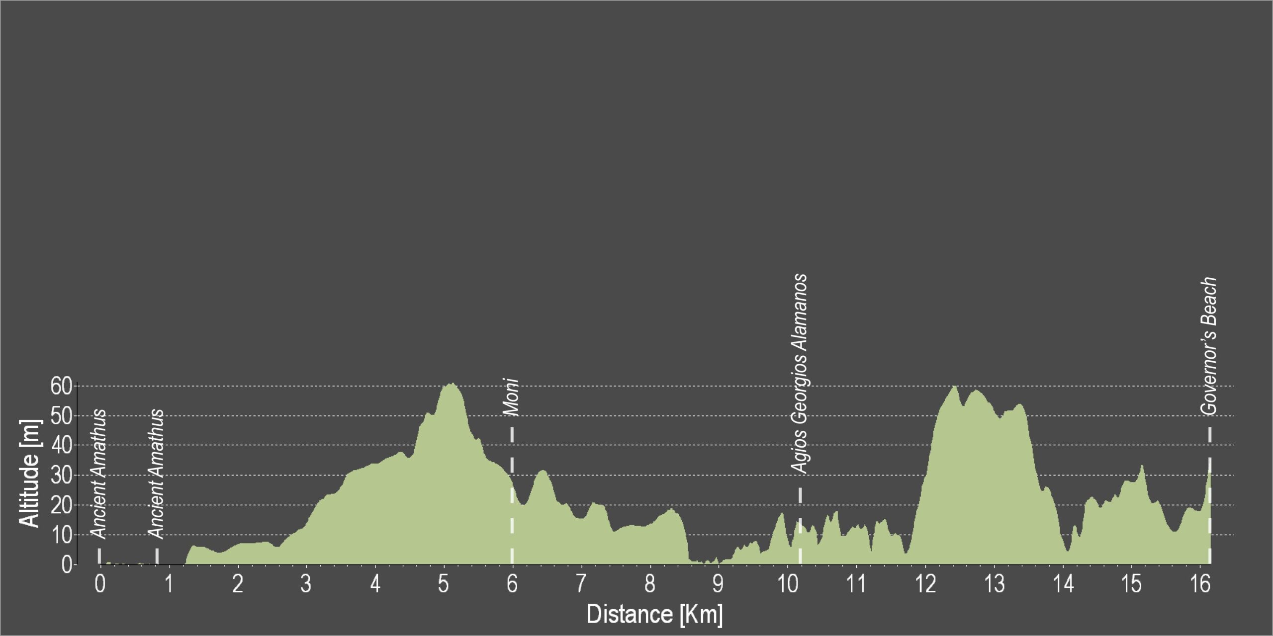
This route starts where the Lemesos-ancient Amathous route ends and goes in the same direction along the old Lemesos-Lefkosia road for 5km until it reaches the Moni flyover. There it turns off onto a dirt road to the right and heads south towards the coast. It goes past a number of industrial units as well as the Moni quarry where it turns left heading east.This part of the route is full of cycling thrills, ending up at Governor’s Beach.

Difficulty rate: Hard and uneven surface.It requires a good quality mountain bike with 24 speeds and front fork suspension.
Road condition: Apart from the first 5km of paved roads, the rest of the route is on an uneven surface.

To download the route in gpx format click here

Distance: 15.4km
Elevation Gain: 214m
Highest point: 67m
Lowest point: 2m
Loop: NO
Terrain: Flat
Road surface: Paved
Section Distance (km) Total Distance (km)
Ancient Amathus 0,0 0,0
Agia Varvara 0,9 0,9
Moni 5,1 6,0
Agios Georgis Alamanos 4,9 10,9
Governor’s Beach 4,5 15,4

Voroklini Hill Cycling Route

Gerakomoutis Hill is situated 207m above sea level and has a chapel dedicated to Profitis Ilias. It offers exciting cycle routes, as well as magnificent views over Larnaka (Larnaca) Bay.

Start Point: Voroklini Hill
End Point: Voroklini Hill
Height Gain: 207m
Difficulty Rating: Various levels of difficulty. Requires a mountain bike with at least 21 speeds and front fork suspension.
Road Conditions: Unpaved territory.