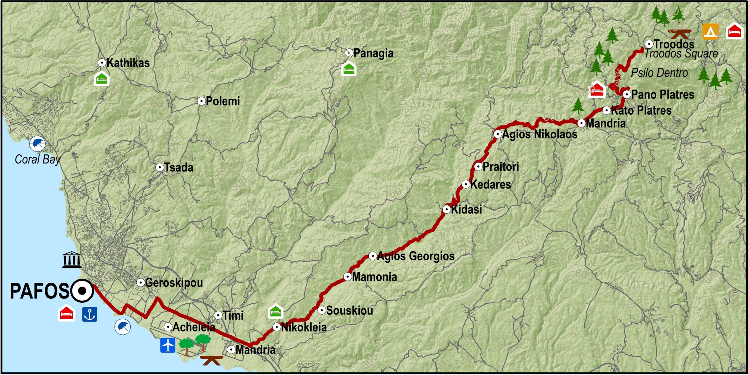
Die 65 kilometer lange Strecke verbindet das Gebiet rund um das Troodos-Gebirge mit Pafos (Paphos) und führt vorbei an den malerischen Dörfern des Diarizos-Flusstals.
Vom Troodos-Platz aus geht es Richtung Süden entlang der Hauptstraße zwischen Lemesos (Limassol) und Troodos. Bei Psilo Dentro führt der Weg nach rechts Richtung Pano Platres und anschließend nach Kato Platres. Unmittelbar vor dem Dorf führt die Strecke rechts nach Mandria und Paphos und weiter in südwestlicher Richtung durch Mandria zum Diarizos-Tal und durch die Dörfer Agios Nikolaos, Praitori, Kedares, Kidasi, Agios Georgios, Mamonia, Fasoula und Nikokleia, bevor sie schließlich die alte Straße zwischen Limassol und Paphos erreicht. Von dort aus geht es Richtung Westen über die Dörfer Mandria, Timi, Acheleia und Geroskipou nach Paphos.
| Ausgangspunkt: | Troodos-Platz |
| Ziel: | Pafos |
| Gesamtstrecke: | 65 kilometer |
| Höhenunterschied: | 20 meter |
| Schwierigkeitsgrad: | Leicht. Hauptsächlich bergab. Das Fahrrad, egal ob Tourenrad oder Mountainbike, sollte gute Bremsen haben. |
| Straßenbedingungen: | Durchgängig asphaltierte Straßen. |
Road condition: Paved road throughout.
Route Description: This excursion links the Troodos area to Pafos via the picturesque villages in the valley of the Diarizos river.
To download the route in gpx format click here
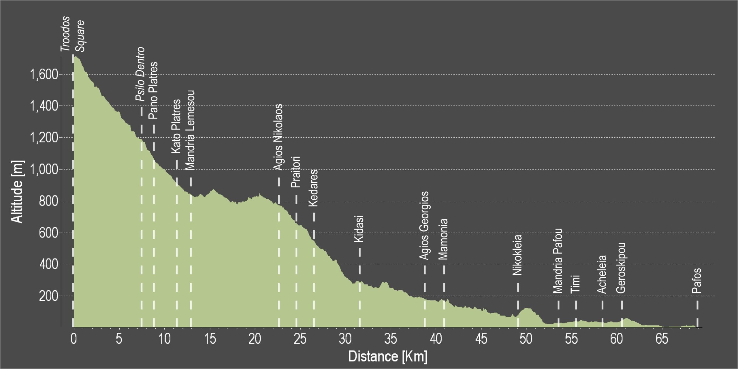
| Distance: | 68.6km |
| Elevation Gain: | 614m |
| Highest point: | 1735m |
| Lowest point: | 1m |
| Loop: | NO |
| Terrain: | Mountain |
| Road surface: | Paved |
| Section Distance (km) | Total Distance (km) | |
| Troodos square | 0,0 | 0,0 |
| Psilo Dendro | 7,6 | 7,6 |
| Pano Platres | 1,3 | 8,9 |
| Kato Platres | 2,6 | 11,5 |
| Mandria | 1,5 | 13,0 |
| Agios Nikolaos | 9,7 | 22,7 |
| Praitori | 1,9 | 24,6 |
| Kedares | 1,7 | 26,3 |
| Kidasi | 5,3 | 31,6 |
| Agios Georgios | 7,2 | 38,8 |
| Mamonia | 2,0 | 40,8 |
| Nikokleia | 8,2 | 49,0 |
| Mandria | 4,6 | 53,6 |
| Timi | 2,1 | 55,7 |
| Acheleia | 2,9 | 58,6 |
| Geroskipou | 1,8 | 60,4 |
| Pafos | 8,2 | 68,6 |