Le monastère d’Agia Napa – Audio Tour

Introduction
Le poème de Georges Seféris «Ayanapa»
Allons maintenant faire le tour du monument
Territoire de la municipalité d’Agia Napa

Pour lire la visit écrit de la Monastère d’Agia Napa, s’il vous plaît cliquez ici.

Pour écouter l’ensemble de la visit de la Monastère d’Agia Napa, s’il vous plaît cliquez ici.

Posted in Uncategorized

Découvrez la beauté de Chypre à EuroVelo8

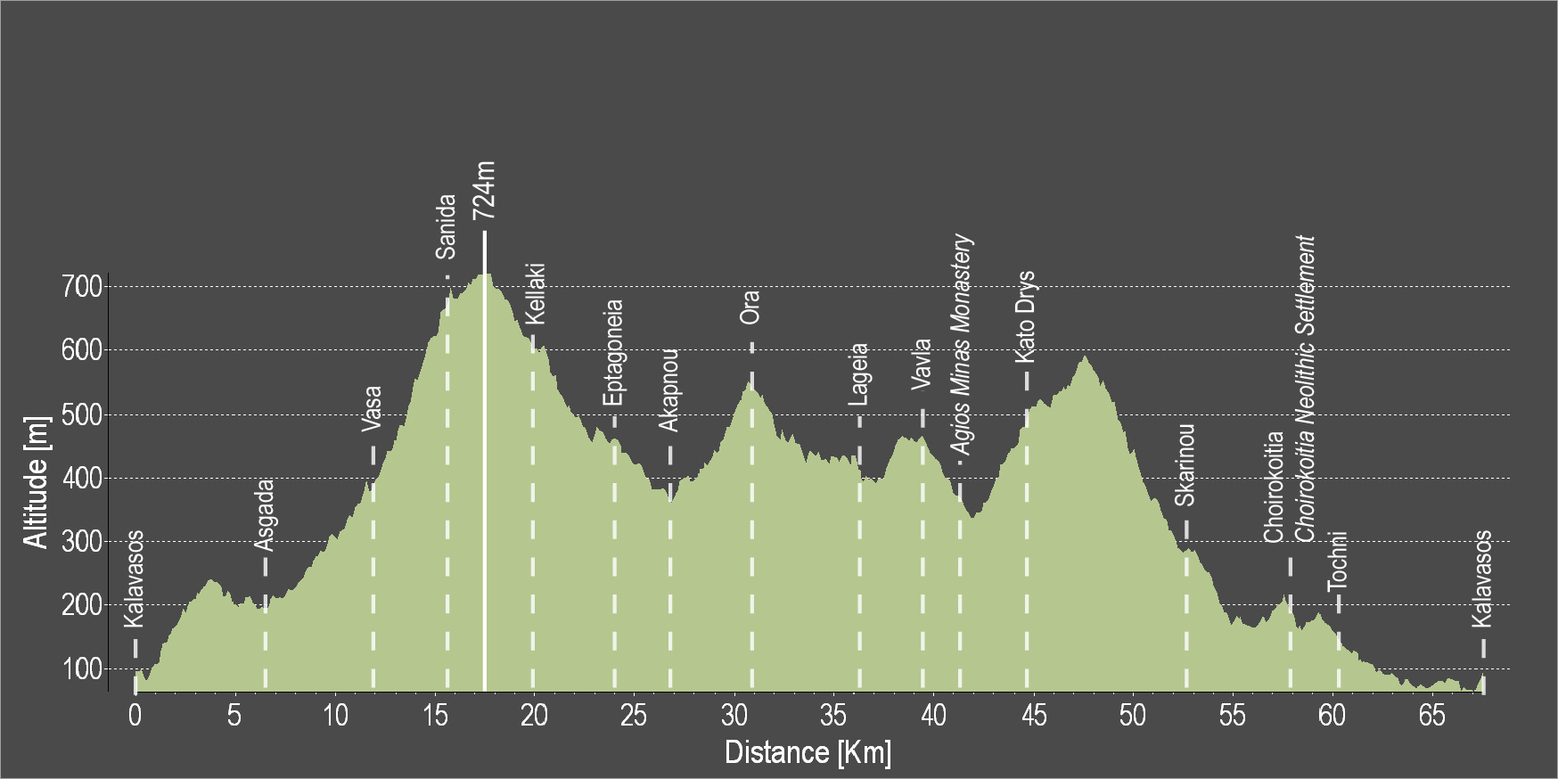
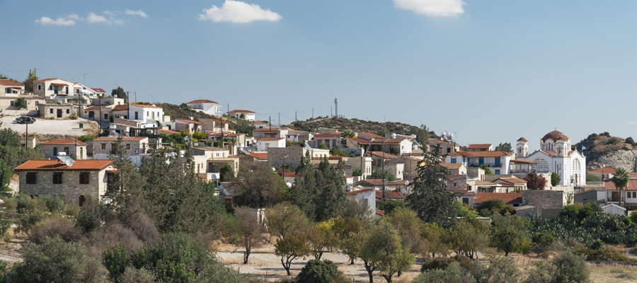
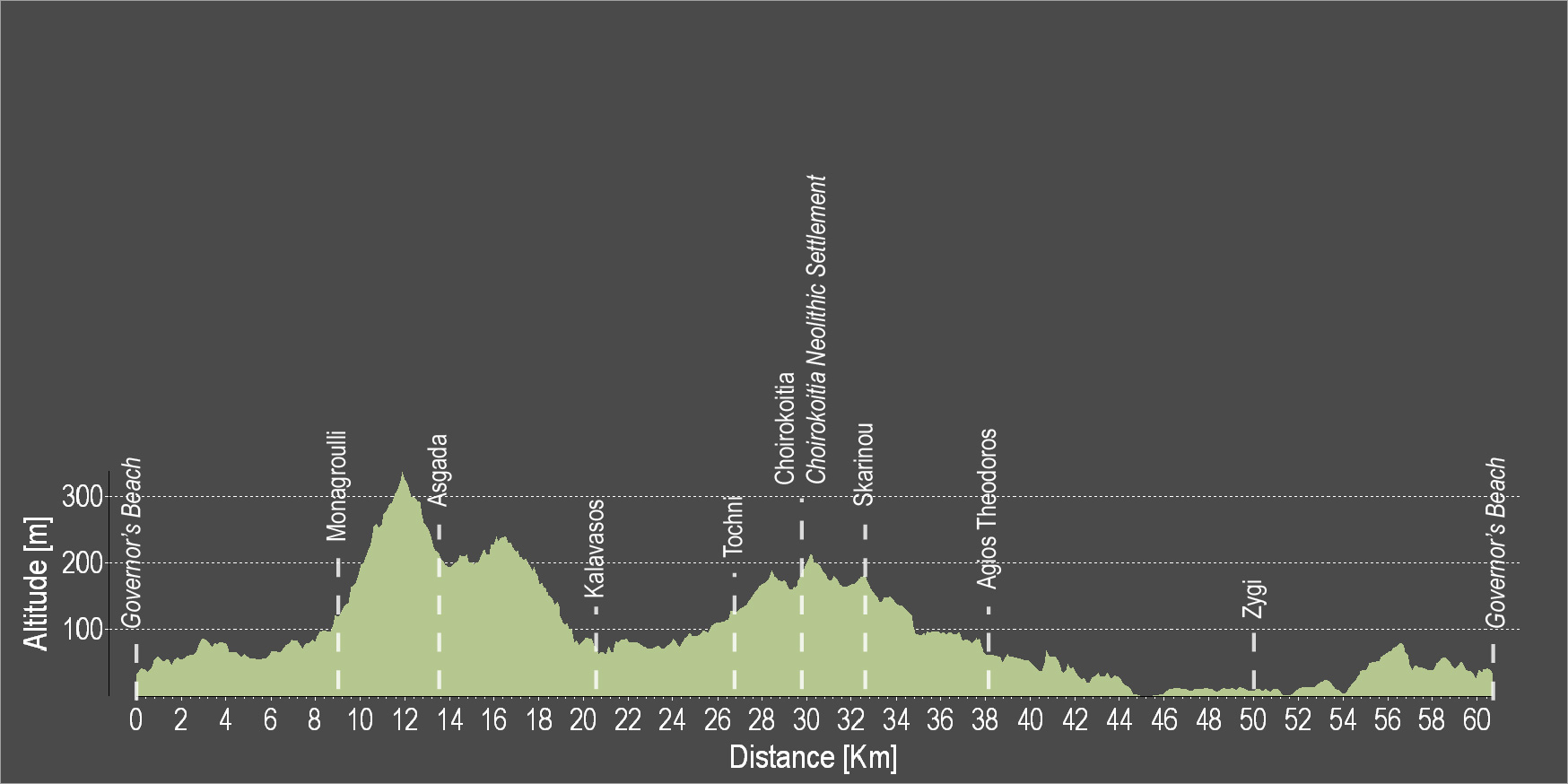
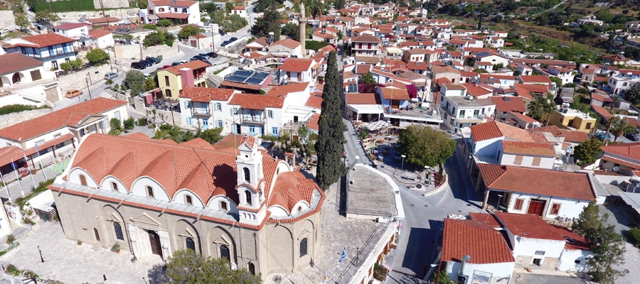
Offrez vous le plaisir d’explorer, à vélo, la beauté naturelle de l’île, en empruntant nos itinéraires et excursions conseillés, tous pensés dans le souci de vous «mettre sur la bonne voie» et vous faire découvrir les paysages époustouflants de l’île.

Les excursions peuvent être choisies telles que présentées, ou être personnalisées selon vos préférences et envies avec l’aide d’agences de voyages agréées. Pour plus d’informations, suivez ce lien.

Chypre fait également partie du projet cofinancé «Eurovélo 8». Ce projet conduit l’aménagement et la promotion de circuits organisés de cyclotourisme, tant sur un plan national, régional que transnational, le long de la «Route de la Méditerranée européenne Eurovelo 8», qui est l’une des 14 véloroutes formant le réseau «Eurovélo» reliant 11 pays.

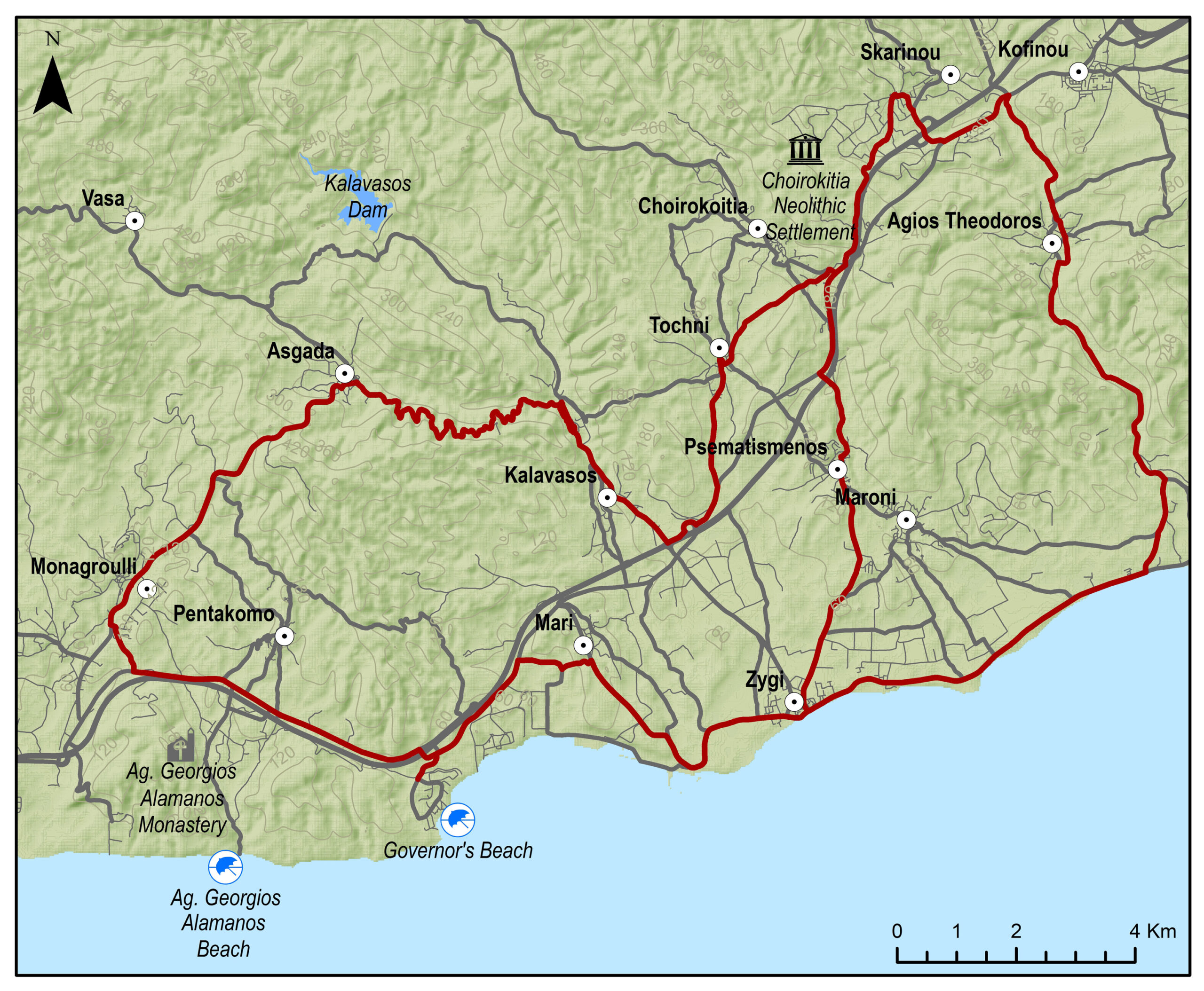
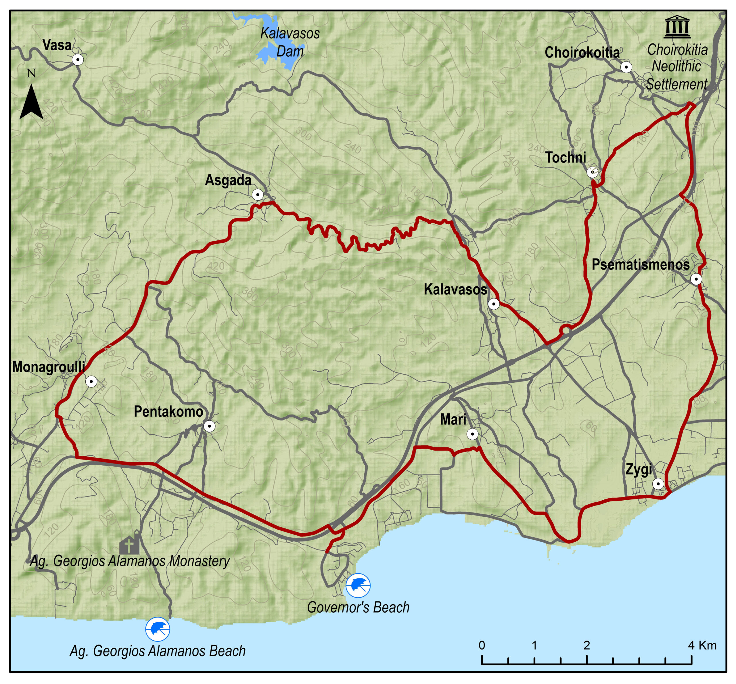
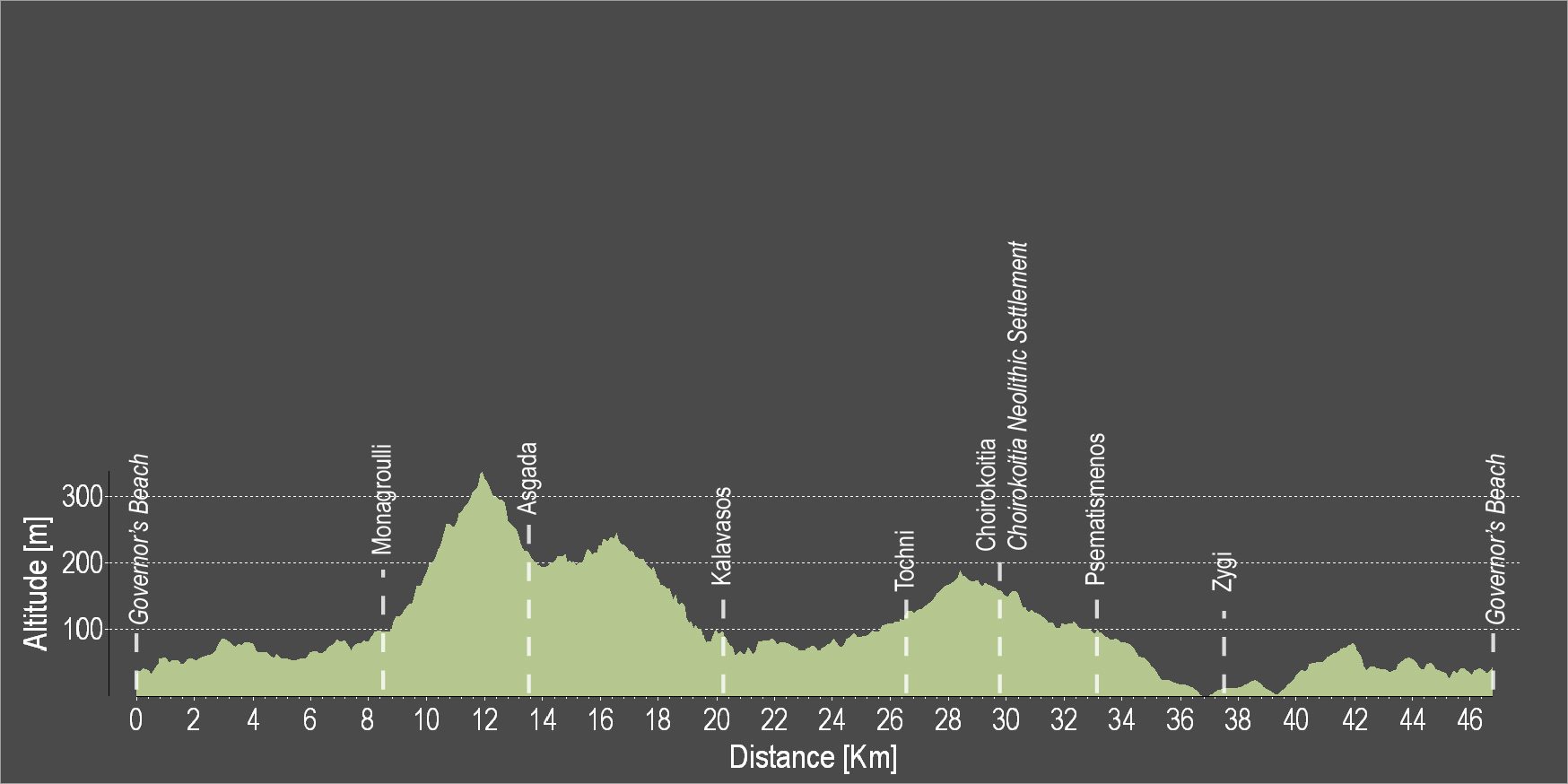
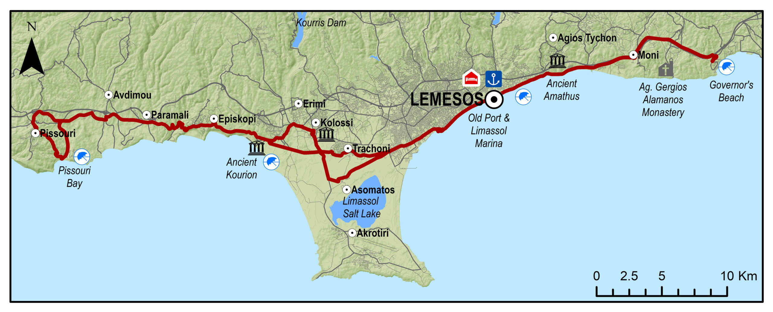
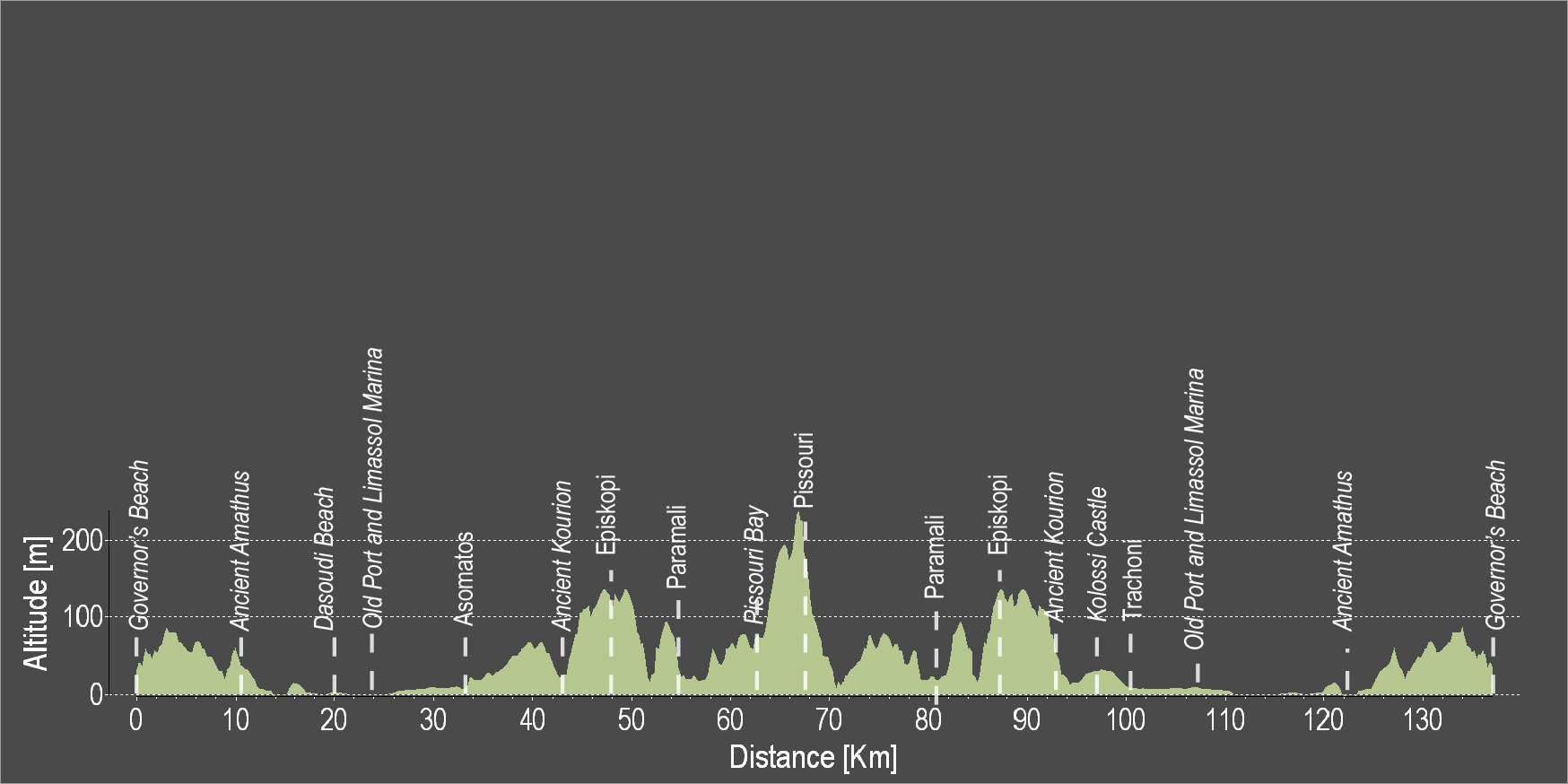
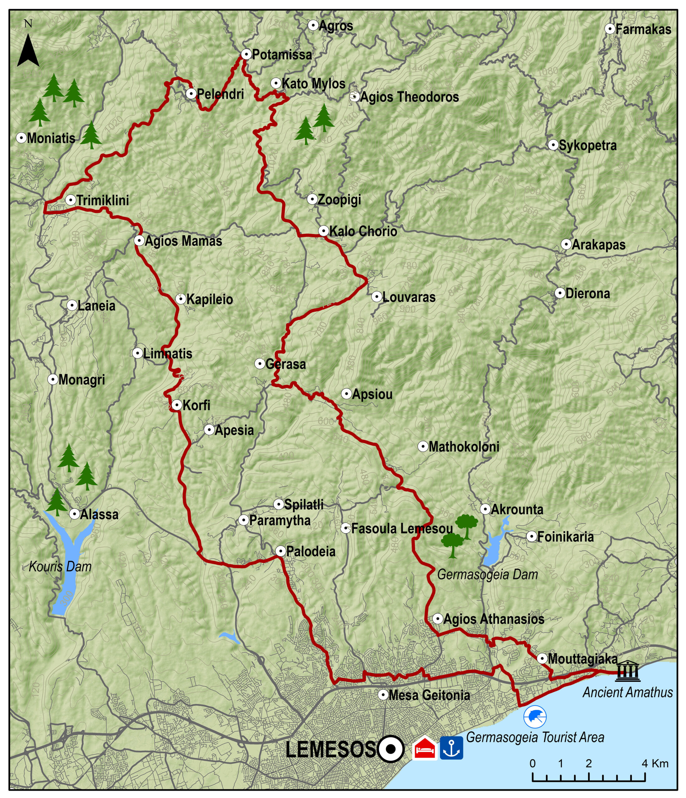
L’itinéraire du tronçon Lemesos (Limassol)/Cap Gkreko a été cartographié et les données géographiques GPSdes deux parties de la route –  Marina de Lemesos/Larnaka et Larnaka/Cap Gkreko – peuvent être téléchargées ici. Quant au dossier contenant les étapes des parcours, il peut également être téléchargé ici.

Pour plus d’informations sur EuroVelo, veuillez visiter: www.eurovelo.com

 
Pour plus d’informations sur EuroVelo 8, veuillez visiter: www.eurovelo8.com
 
Pour plus d’informations sur le projet MedCycleTour, veuillez visiter: https://medcycletour.interreg-med.eu/ ou veuillez contacter Thalia Christodoulidou à [email protected].

Bonne balade à vélo !


Vasilikos Maroni Panorama

The route starts from the village of Kalavasos with a slight uphill ascent towards the village of Asgata. Pass through the narrow streets of the village and continue uphill to Vasa, Sanida and then to Kellaki. Woodland areas and unique views will be encountered along the way. Ride downhill to reach the Eptagoneia Village and the small picturesque village of Akapnou. Continue towards Ora, Lageia, Vavla and ride further downhill to Choirokoitia. Pass through the village of the picturesque and beautiful Tochni to reach the starting point in Kalavasos.

To download the route in gpx format click here

Distance: 57.6km
Elevation Gain: 1169m
Highest point: 724m
Lowest point: 65m
Loop: YES
Terrain: Mountain
Road surface: Paved
Section Distance (km) Total Distance (km)
Kalavasos 0,0 0,0
Asgada 6.6 6.6
Vasa 5.1 11.7
Sanida 3.6 15.3
Kellaki 4.1 19.4
Eptagonia 4.5 23.9
Akapnou 3.0 26.9
Ora 3.5 30.4
Lageia 6.3 36.7
Vavla 2.4 39.1
Choirokoitia 9.7 48.8
Choirokoitia Neolithic Settlement 0.0 48.8
Tochni 2.8 51.6
Kalavasos 6.0 57.6

Vasilikos Maroni Panorama Intense

The route starts from the village of Kalavasos with a slight uphill ascent towards the village of Asgata. Pass through the narrow streets of the village and continue uphill to Vasa, Sanida and then to Kellaki. Woodland areas and unique views will be encountered along the way. Ride downhill to reach the Eptagoneia Village and the small picturesque village of Akapnou. Continue towards Ora, Lageia, Vavla and then ride uphill to Kato Drys village. A big downhill ride will follow which leads to the village of Skarinou. Pass through the village and continue to Choirokoitia and then to beautiful Tochni. Continue straight ahead to reach the starting point of the route in Kalavasos.

To download the route in gpx format click here

Distance: 67.3km
Elevation Gain: 1484m
Highest point: 724m
Lowest point: 65m
Loop: YES
Terrain: Mountain
Road surface: Paved
Section Distance (km) Total Distance (km)
Kalavasos 0.0 0.0
Asgada 6.6 6.6
Vasa 5.1 11.7
Sanida 3.6 15.3
Kellaki 4.1 19.4
Eptagoneia 4.5 23.9
Akapnou 3.0 26.9
Ora 3.5 30.4
Lageia 6.3 36.7
Vavla 2.4 39.1
Agios Minas Monastery 2.4 41.5
Kato Drys 3.1 44.6
Skarinou 9.0 53.6
Choirokoitia 4.1 57.7
Choirokoitia Neolithic Settlement 0.0 57.7
Tochni 2.7 60.4
Kalavasos 6.9 67.3

Ancient Vasilikos Extended

The route starts at the Governor’s Beach heading west to Monagroulli. A three kilometre uphill ride will lead to the beautiful village of Asgata. Pass through the narrow streets of the village and go downward to Kalavasos. The paved traditional streets, the grand church of the Virgin Mary and the Mosque are some of the many things to admire in Kalavasos. Then, head south and discover the village of Tochni where the ancient church of the village is bound to impress. The village of Choirokoitia is next, where the Neolithic Settlement of Choirokoitia is located, which has been listed as a UNESCO World Heritage Site since 1998. Skarinou and Agios Theodoros are the villages to follow before reaching Zygi and the Zygi Marina. Continue towards Vasiliko to finish the circular route at Governor’s Beach.

To download the route in gpx format click here

Distance: 60.2km
Elevation Gain: 806m
Highest point: 336m
Lowest point: 3m
Loop: YES
Terrain: Mixed
Road surface: Paved
Section Distance (km) Total Distance (km)
Governor’s Beach 0.0 0.0
Monagrouli 8.5 8.5
Asgada 5.1 13.6
Kalavasos 6.7 20.3
Tochni 6.1 26.4
Choirokoitia 3.0 29.4
Choirokoitia Neolithic Settlement 0.0 29.4
Skarinou 3.1 32.5
Agios Theodoros 5.3 37.8
Zygi 12.4 50.2
Governor’s Beach 10.0 60.2

Ancient Vasilikos

The route starts at the Governor’s Beach and heads westward to Monagroulli. A three kilometre uphill ride will lead to the beautiful village of Asgata. Pass  through the narrow streets of the village and go downward to Kalavasos. The paved traditional streets, the grand church of the Virgin Mary and the Mosque are some of the many things to admire in Kalavasos. Then, head south and discover the village of Tochni where the ancient church of the village is bound to impress. Choirokoitia and Psematismenos are the villages to follow before reaching Zygi and the Zygi Marina. Continue towards Vasiliko to finish the circular route at Governor’s Beach.

To download the route in gpx format click here

Distance: 47.2km
Elevation Gain: 677m
Highest point: 338m
Lowest point: 3m
Loop: YES
Terrain: Mixed
Road surface: Paved
Section Distance (km) Total Distance (km)
Governor’s Beach 0,0 0,0
Monagroulli 8.5 8.5
Asgada 5.1 13.6
Kalavasos 6.7 20.3
Tochni 6.1 26.4
Choirokoitia 3.0 29.4
Choirokoitia Neollithic Settlement 0.0 29.4
Psematismenos 3.3 32.7
Zygi 4.5 37.2
Governor’s Beach 10.0 47.2

Divine Coast

The route starts from Governor’s Beach and heads towards the coast and westward towards Lemesos. Cross Lemesos by going along the entire coastline of the city, from the Molos area, to the old port, to Limassol Marina, etc. Continue west and pass through the archaeological site of Kourion where the ancient theatre of Kourion is located. Ride uphill to the Sanctuary of Apollon Hylates and continue to reach the Episkopi and the Happy Valley. Pass through the Paramali village and end the route in Pissouri and Pissouri Bay.

To download the route in gpx format click here

Distance: 131.2km
Elevation Gain: 1191m
Highest point: 241m
Lowest point: 2m
Loop: YES
Terrain: Mixed
Road surface: Paved
Section Distance (km) Total Distance (km)
Governor’s Beach 0,0 0,0
Ancient Amathus 10.5 10.5
Dasoudi Beach 9.5 20.0
Old Port 4.3 24.3
Limassol Marina 0.6 24.9
asomatos 8.2 33.1
Ancient Kourion 9.5 42.6
Episkopi 4.9 47.5
Paramali 5.6 53.1
Pissouri Bay 10.5 63.6
Pissouri 3.3 66.9
Paramali 11.5 78.4
Episkopi 5.5 83.9
Ancient Kourion 5 88.9
Kolossi Castle 5.5 94.4
Trachoni 4.6 99
Limassol Marina 7.2 106.2
Old Port 0.6 106.8
Dasoudi Beach 4.3 111.1
Ancient Amathus 10.5 121.6
Governor’s Beach 9.6 131.2

Η καρδιά της κουμανταρίας

Η διαδρομή ξεκινά από Αμαθούντα, περνά από Γερμασόγεια και ανηφορίζει για Μαθηκολώνη. Αψιού και Γεράσα είναι τα επόμενα δύο χωριά για να φτάσουμε στο Καλό Χωριό. Η διαδρομή οδηγεί μέσα από την πευκόφυτη περιοχή όλο και πιο βόρεια στο γραφικό χωριό Ποταμίτισσα και στην συνέχεια στο μεγαλύτερο χωριό της περιοχής, το Πελένδρι. Μεγάλο κατήφορο θα μας οδηγήσει στον Σαϊττά και από εκεί ανηφορίζουμε για Άγιο Μάμα, Καπηλιό, Κορφή, Παραμύθα. Παλώδια είναι το τελευταίο χωριό πριν να φτάσουμε στην Λεμεσό και να κατευθυνθούμε προς το σημείο εκκίνησης στην Αμαθούντα.

Για να κατεβάσετε σε μορφή gpx πατήστε εδώ

Distance: 97.2km
Elevation Gain: 2112m
Highest point: 964m
Lowest point: 1m
Loop: YES
Terrain: Mountain
Road surface: Paved
Section Distance (km) Total Distance (km)
Ancient Amathus 0,0 0,0
Mouttagiaka 4.0 4.0
Germasogia 2.1 6.1
Agios Athanasios 2.5 8.6
Mathikoloni 8.0 16.6
Apsiou 3.4 20.0
Gerasa 3.4 23.4
Louvaras 6.2 29.6
Kalo Chorio 2.7 32.3
Kato Mylos 8.8 41.1
Potamitissa 3 44.1
Pelendri 5.6 49.7
Trimiklini 8.5 58.2
Agios Mamas 3.6 61.8
Korifi 8.6 70.4
Apesia 1.5 71.9
Pallodia 6 77.9
Agia Fylaxis 3.5 81.4
Mesa Geitonia 3.5 84.9
Ancient Amathus 12.3 97.2