Einleitung
Gedicht Agia Napa von Georgios Seferis
Eine virtuelle Besichtigungstour
Innerhalb des Bezirks von Agia Napa
Zum Lesen der schriftlichen Tour klicken Sie bitte hier.
Zum Anhören der gesamten Tour klicken Sie bitte hier.
Einleitung
Gedicht Agia Napa von Georgios Seferis
Eine virtuelle Besichtigungstour
Innerhalb des Bezirks von Agia Napa
Zum Lesen der schriftlichen Tour klicken Sie bitte hier.
Zum Anhören der gesamten Tour klicken Sie bitte hier.

Discover and enjoy the natural beauty of the island from the pedal of a bike with our suggested itineraries, all created to put you on the ‘right track’ and showcase Cyprus’ stunning landscape.
Cyprus is also part of the cofunded project ‘MedCycleTour’, which is based on the ‘European Mediterranean Route – EuroVelo 8’, one of the 15 long distance cycle routes in the network ‘EuroVelo’ that connects 11 countries. ‘MedCycleTour’ aims to develop cycle tourism in the Mediterranean region by providing transnational tools to attract visitors. The project is cofunded by the Interreg Mediterranean Programme, the project has a budget of over €2,5 million.
The MedCycleRoute project will contribute to the development of the EuroVelo 8 – Mediterranean Route by exchanging good practices; surveying the existing cycle route; developing regional and transnational action plans; preparing and publishing promotional material related to EuroVelo 8; and implementing pilot projects such as signposting, promotional tools (web sites, apps, etc.) and cycle friendly schemes.
Lead by the Andalusian Government – Agency of Public Works, Andalusian Ministry of Development and Housing (Spain) -, the project has 10 other partners from 7 countries, besides the Deputy Ministry of Tourism. The European Cyclists´ Federation (Belgium), Alpes Maritimes (France), Catalonia Region (Spain), Western Greece (Greece), Friuli Venezia Giulia Region (Italy), Province of Mantova (Italy), Regional Development Center of Koper (Slovenia), Croatian National Tourism Board (Croatia) and the Cluster for Eco-Social Innovation and Development (Croatia).
For more information about EuroVelo please visit: www.eurovelo.com
For more information about EuroVelo 8 please visit: www.eurovelo8.com
For more information about MedCycleTour project please visit: https://medcycletour.interreg-med.eu/ or please contact Thalia Christodoulidou at [email protected].
Happy cycling!

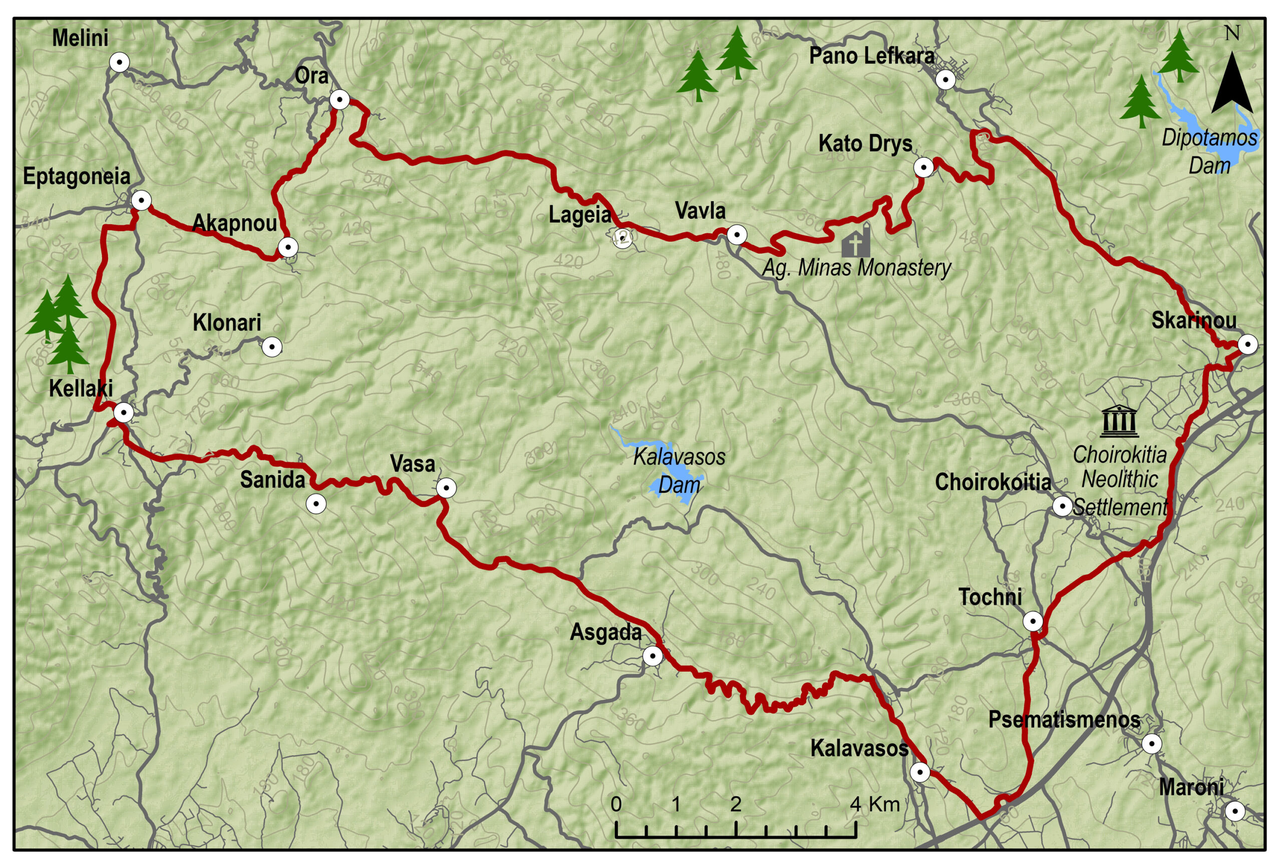
Amathus – Germasogia – Arakapas – Eptagonia – Kellaki – Sanida – Vasa – Asgata – Monagroulli – Moni – Pyrgos – Amathus
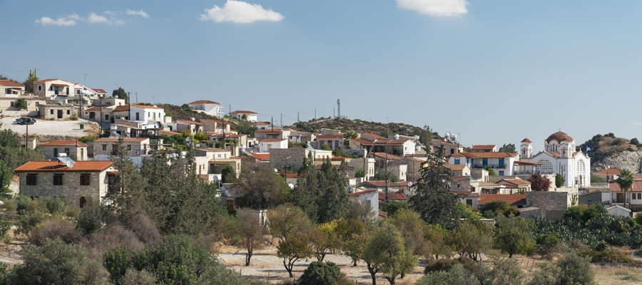
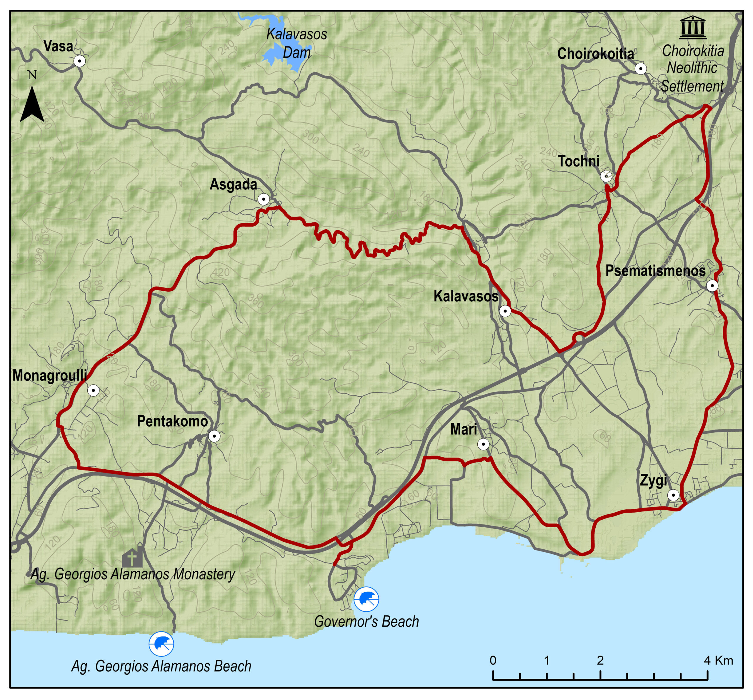
Eine fordernde Runde, die von Kalavasos entlang der Gebirgsstraße nach Kellaki führt und dabei herrliche Blicke auf den Mount Olympus im Nordwesten und das Vasilikos-Tal zur rechten eröffnet. Das Land zwischen Eptagonia und Vavla ist von Lavaböden und satten Wäldern geprägt. Dann ändert sich die Landschaft plötzlich Wieder zu Kalkstein. Nun geht es entlang des beeindruckenden Maroni-Tals einem schon in der späten Bronzezeit (1.650-1.050 v. Chr.) wichtigen Siedlungsraum – über Choirokoitia und Tochni zurück nach Kalavasos.
Bitte klicken sie hier zum download die beschreibung der route.
Bitte klicken sie hier zum download die route im gpx-format.
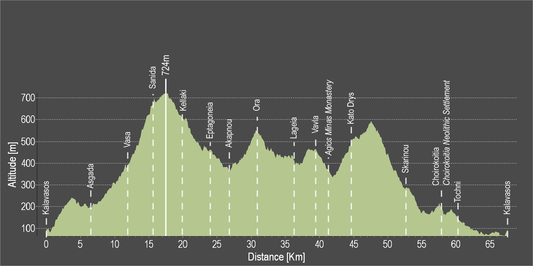
| Distance: | 57.6km |
| Elevation Gain: | 1169m |
| Highest point: | 724m |
| Lowest point: | 65m |
| Loop: | YES |
| Terrain: | Mountain |
| Road surface: | Paved |
| Section Distance (km) | Total Distance (km) | |
| Kalavasos | 0,0 | 0,0 |
| Asgada | 6.6 | 6.6 |
| Vasa | 5.1 | 11.7 |
| Sanida | 3.6 | 15.3 |
| Kellaki | 4.1 | 19.4 |
| Eptagonia | 4.5 | 23.9 |
| Akapnou | 3.0 | 26.9 |
| Ora | 3.5 | 30.4 |
| Lageia | 6.3 | 36.7 |
| Vavla | 2.4 | 39.1 |
| Choirokoitia | 9.7 | 48.8 |
| Choirokoitia Neolithic Settlement | 0.0 | 48.8 |
| Tochni | 2.8 | 51.6 |
| Kalavasos | 6.0 | 57.6 |
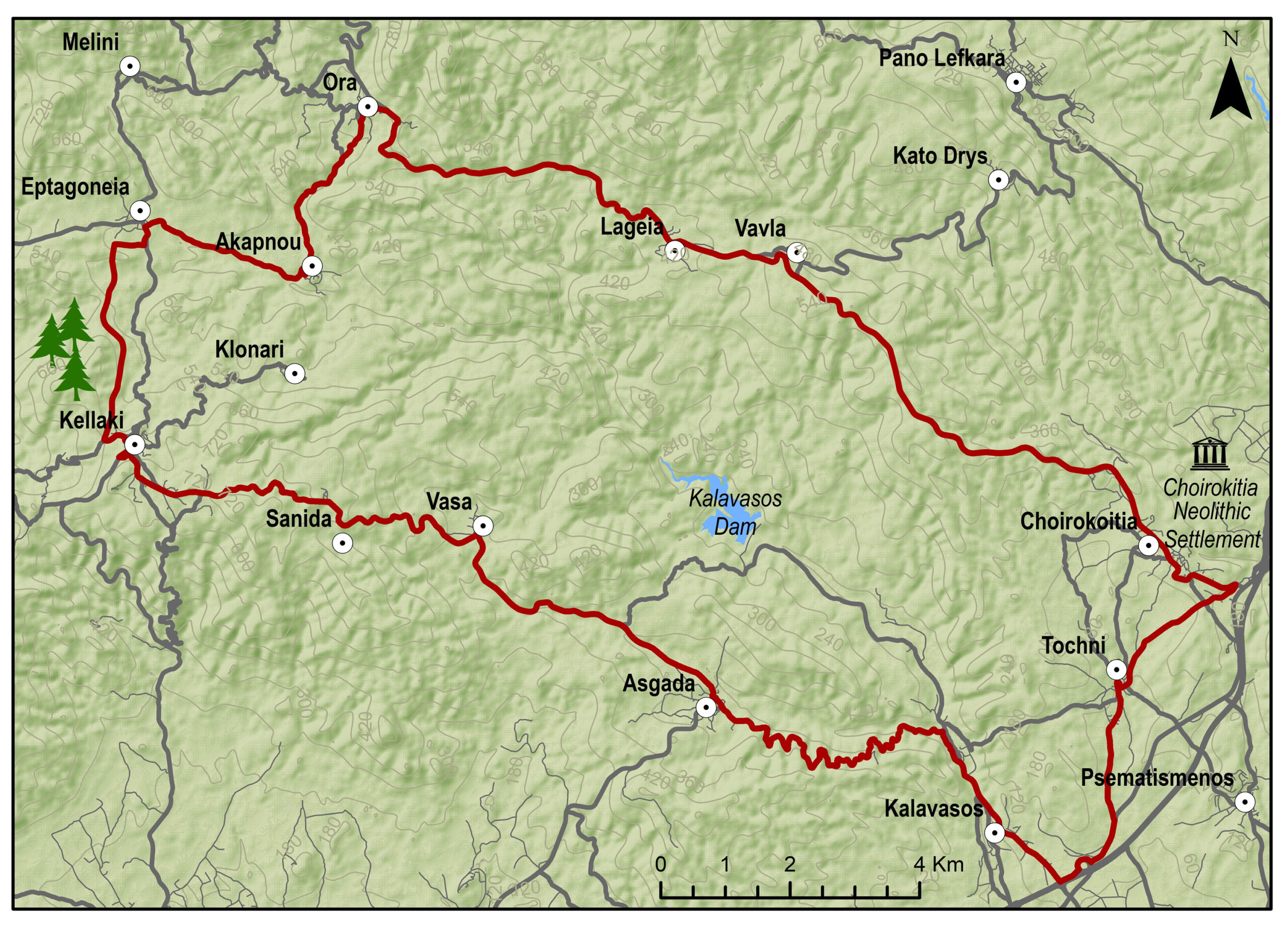

Kalavasos – Asgata – Kellaki – Eptagonia – Ora – Vavla – Kato Drys – Skarinou – Tochni – Kalavasos
Eine fordernde Runde, die von Kalavasos entlang der Gebirgsstraße nach Kellaki führt und dabei herrliche Blicke auf den Mount Olympus im Nordwesten und das Vasilikos-Tal zur rechten eröffnet. Das Land zwischen Eptagonia und Vavla ist von Lavaböden und satten Wäldern geprägt. Dann ändert sich die Landschaft plötzlich Wieder zu Kalkstein. Von hier geht es hinab in das beeindruckende Maroni-Tal und vorbei am Agios Minas Kloster wieder aufwärts ins reizende Dörfchen Kato Drys. Die temporeiche Abfahrt nach Skarinou und die Fahrt durch Tochni sind weitere Highlights auf dem Rückweg nach Kalavasos.
Bitte klicken sie hier zum download die beschreibung der route.
Bitte klicken sie hier zum download die route im gpx-format.
| Distance: | 67.3km |
| Elevation Gain: | 1484m |
| Highest point: | 724m |
| Lowest point: | 65m |
| Loop: | YES |
| Terrain: | Mountain |
| Road surface: | Paved |
| Section Distance (km) | Total Distance (km) | |
| Kalavasos | 0.0 | 0.0 |
| Asgada | 6.6 | 6.6 |
| Vasa | 5.1 | 11.7 |
| Sanida | 3.6 | 15.3 |
| Kellaki | 4.1 | 19.4 |
| Eptagoneia | 4.5 | 23.9 |
| Akapnou | 3.0 | 26.9 |
| Ora | 3.5 | 30.4 |
| Lageia | 6.3 | 36.7 |
| Vavla | 2.4 | 39.1 |
| Agios Minas Monastery | 2.4 | 41.5 |
| Kato Drys | 3.1 | 44.6 |
| Skarinou | 9.0 | 53.6 |
| Choirokoitia | 4.1 | 57.7 |
| Choirokoitia Neolithic Settlement | 0.0 | 57.7 |
| Tochni | 2.7 | 60.4 |
| Kalavasos | 6.9 | 67.3 |
Governor’s Beach – Monagroulli – Asgata – Kalavasos – Tochni – Skarinou – Agios Theodoros – Zygi – Governor’s Beach
Von Governor’s Beach führt diese Runde über Asgata hinab in das Vasilikos-Tal, in dem seit Jahrtausenden Menschen siedeln und unzählige archäologische Funde gemacht wurden. Vorbei an den Dörfern Kalavasos, Tochni und Skarinou wendet sich die Tour nach Agios Theodoros und weiter bis zur Küste. Durch das Fischerdorf Zygi geht es an der Küste entlang zurück nach Governor’s Beach.
Bitte klicken sie hier zum download die beschreibung der route.
Bitte klicken sie hier zum download die route im gpx-format.
| Distance: | 60.2km |
| Elevation Gain: | 806m |
| Highest point: | 336m |
| Lowest point: | 3m |
| Loop: | YES |
| Terrain: | Mixed |
| Road surface: | Paved |
| Section Distance (km) | Total Distance (km) | |
| Governor’s Beach | 0.0 | 0.0 |
| Monagrouli | 8.5 | 8.5 |
| Asgada | 5.1 | 13.6 |
| Kalavasos | 6.7 | 20.3 |
| Tochni | 6.1 | 26.4 |
| Choirokoitia | 3.0 | 29.4 |
| Choirokoitia Neolithic Settlement | 0.0 | 29.4 |
| Skarinou | 3.1 | 32.5 |
| Agios Theodoros | 5.3 | 37.8 |
| Zygi | 12.4 | 50.2 |
| Governor’s Beach | 10.0 | 60.2 |
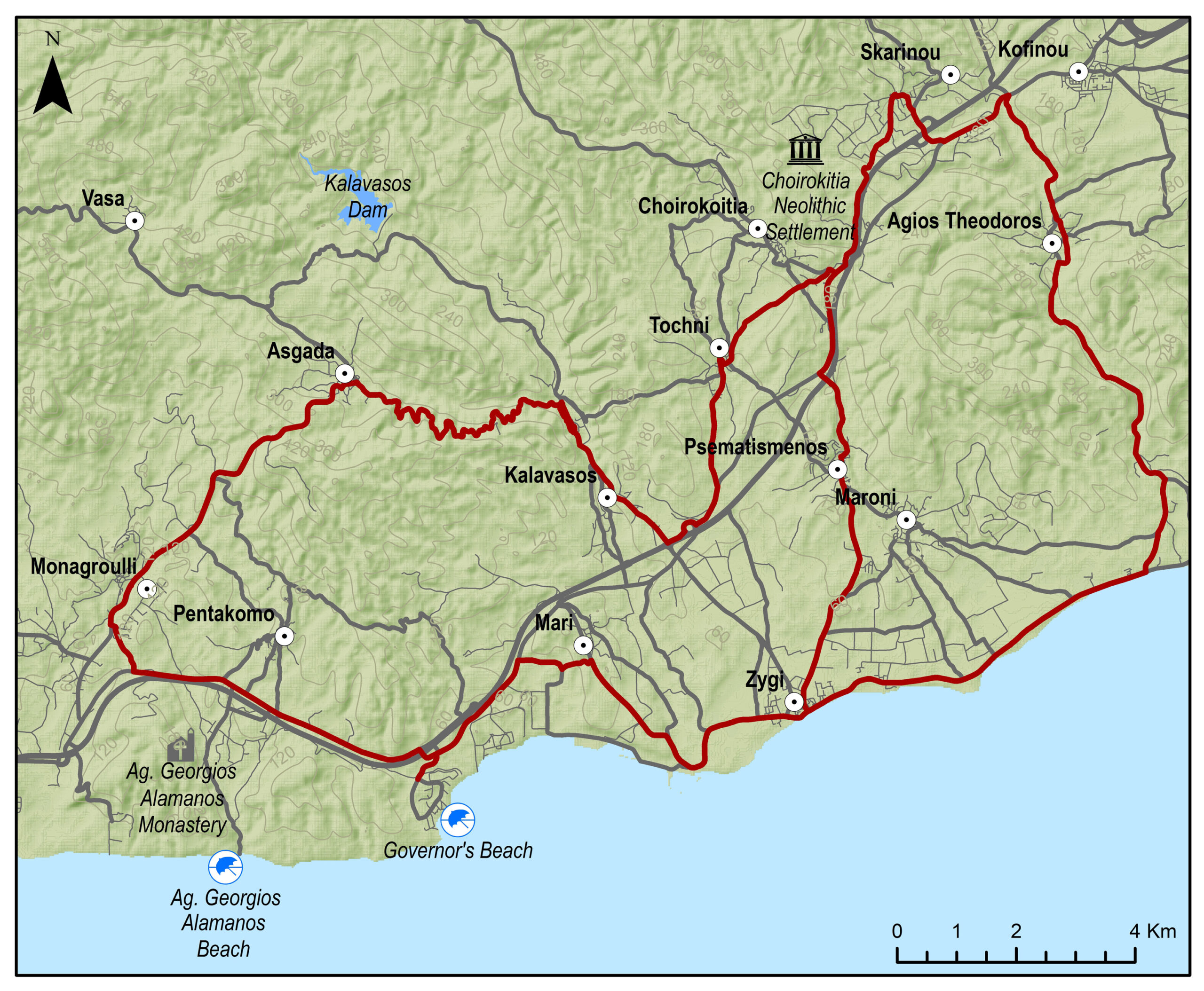
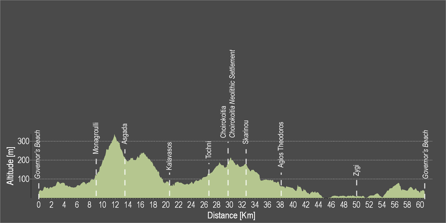
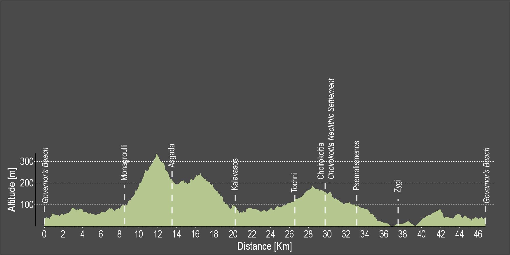
Governor’s Beach – Monagroulli – Asgata – Kalavasos – Tochni – Skarinou – Psematismenos – Zygi – Governor’s Beach
Von Governor’s Beach führt diese entspannte Runde zunächst nach Monagrouli und von dort in das Vasilikos-Tal, in dem seit Jahrtausenden Menschen siedeln und unzählige archäologische Funde gemacht wurden. Nach Kalavasos, Tochni und Choirokoitia wendet sich die Tour nach Süden Richtung Psematismenos und weiter durch den fruchtbaren Küstenstreifen nach Zygi, Mari und zurück zum Ausgangspunkt.
Bitte klicken sie hier zum download die beschreibung der route.
Bitte klicken sie hier zum download die route im gpx-format.
| Distance: | 47.2km |
| Elevation Gain: | 677m |
| Highest point: | 338m |
| Lowest point: | 3m |
| Loop: | YES |
| Terrain: | Mixed |
| Road surface: | Paved |
| Section Distance (km) | Total Distance (km) | |
| Governor’s Beach | 0,0 | 0,0 |
| Monagroulli | 8.5 | 8.5 |
| Asgada | 5.1 | 13.6 |
| Kalavasos | 6.7 | 20.3 |
| Tochni | 6.1 | 26.4 |
| Choirokoitia | 3.0 | 29.4 |
| Choirokoitia Neollithic Settlement | 0.0 | 29.4 |
| Psematismenos | 3.3 | 32.7 |
| Zygi | 4.5 | 37.2 |
| Governor’s Beach | 10.0 | 47.2 |
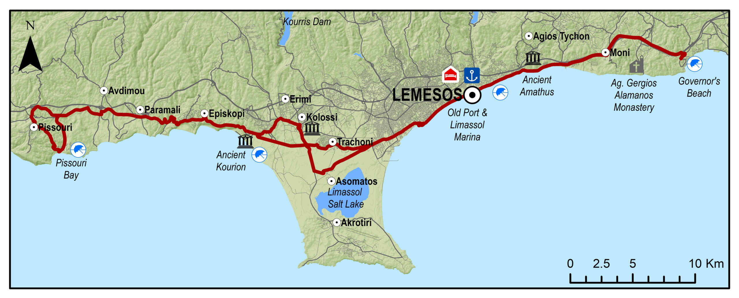
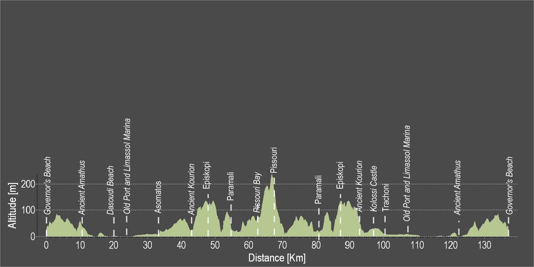
Governor’s Beach – Amathus – Lemesos (Limassol) – Episkopi – Pissouri Bay – Pissouri – Kolossi – Limassol – Amathus – Governor’s Beach
Von Govenor’s Beach führt diese Tour immer an der Küste entlang durch das legendäre, heute recht moderne Amathus bis zur Marina von Limassol. Vor dort führt die Strecke über die Akrotiri-Halbinsel durch die Zitrusplantagen nach Koúrion, einer der beeindruckensten archälogischen Stätten Zyperns. Auf halber Strecke lädt Pissouri Bay zu einer (Bade-)Pause ein. Endlos weite Blicke über das Meer und die Ebene bis hin zum Troodosgebirge lohnen den Aufstieg nach Pissouri. Auf dem Rückweg wartet die Kreuzfahrer-Hochburg Kolossi, wo Richard Löwenherz einst Hochzeit feierte und die später zu einem Zentrum der zypriotischen Zuckerindustrie aufstieg.
Bitte klicken sie hier zum download die beschreibung der route.
Bitte klicken sie hier zum download die route im gpx-format.
| Distance: | 131.2km |
| Elevation Gain: | 1191m |
| Highest point: | 241m |
| Lowest point: | 2m |
| Loop: | YES |
| Terrain: | Mixed |
| Road surface: | Paved |
| Section Distance (km) | Total Distance (km) | |
| Governor’s Beach | 0,0 | 0,0 |
| Ancient Amathus | 10.5 | 10.5 |
| Dasoudi Beach | 9.5 | 20.0 |
| Old Port | 4.3 | 24.3 |
| Limassol Marina | 0.6 | 24.9 |
| asomatos | 8.2 | 33.1 |
| Ancient Kourion | 9.5 | 42.6 |
| Episkopi | 4.9 | 47.5 |
| Paramali | 5.6 | 53.1 |
| Pissouri Bay | 10.5 | 63.6 |
| Pissouri | 3.3 | 66.9 |
| Paramali | 11.5 | 78.4 |
| Episkopi | 5.5 | 83.9 |
| Ancient Kourion | 5 | 88.9 |
| Kolossi Castle | 5.5 | 94.4 |
| Trachoni | 4.6 | 99 |
| Limassol Marina | 7.2 | 106.2 |
| Old Port | 0.6 | 106.8 |
| Dasoudi Beach | 4.3 | 111.1 |
| Ancient Amathus | 10.5 | 121.6 |
| Governor’s Beach | 9.6 | 131.2 |
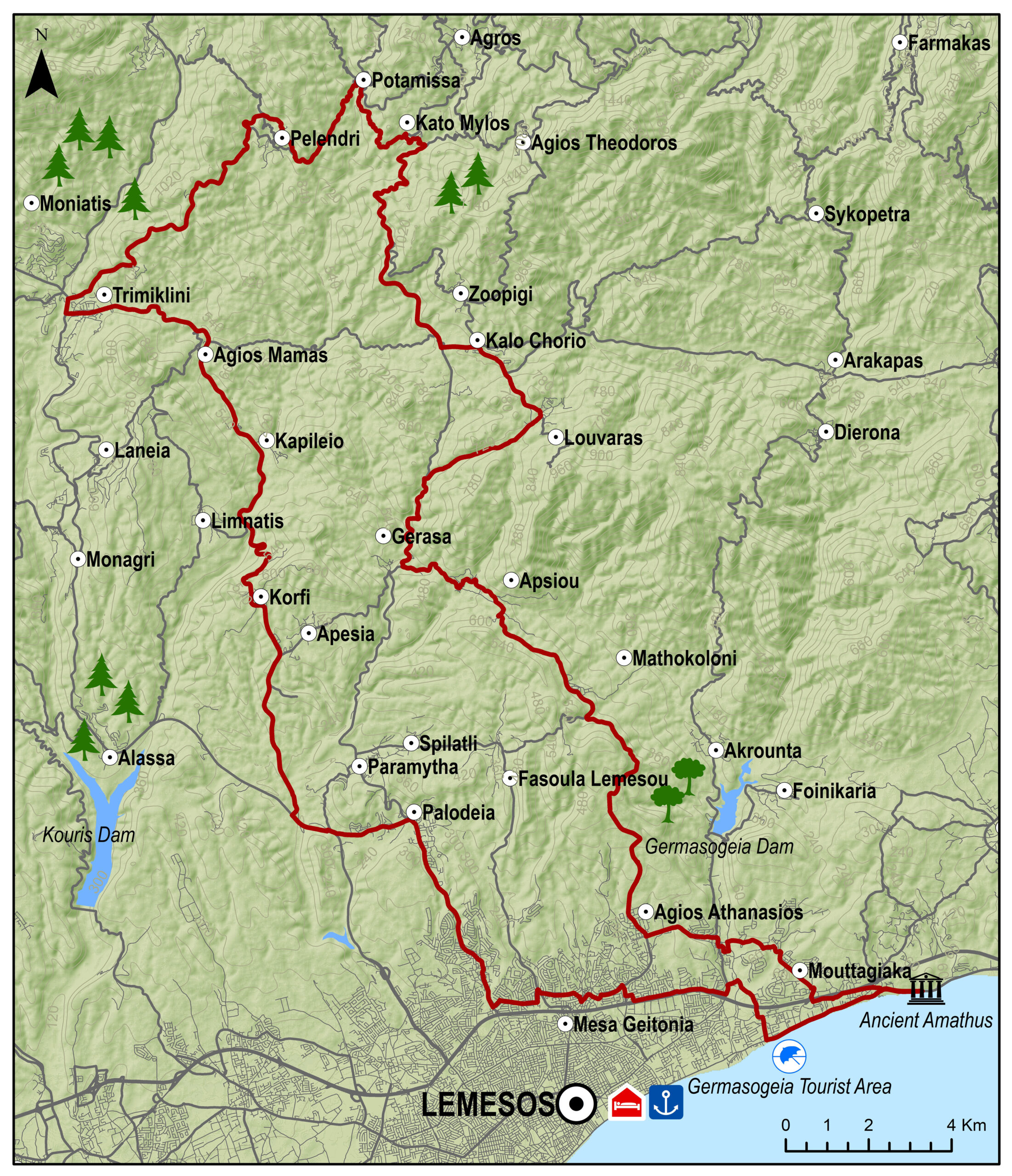
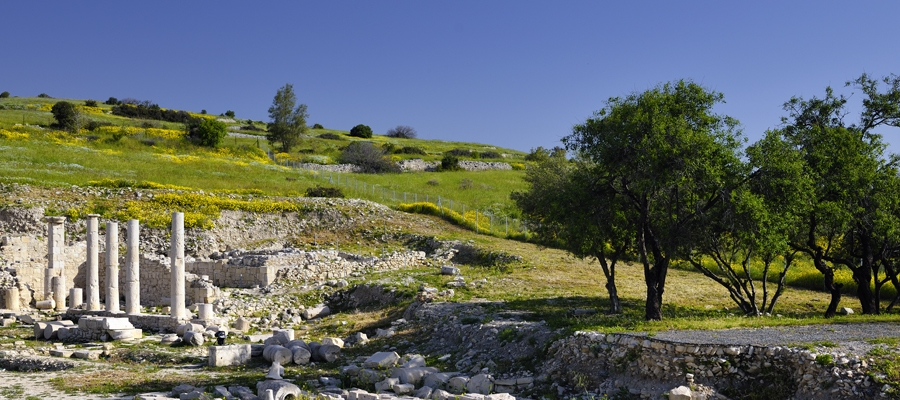
Amathus – Germasogia – Mathikoloni – Gerasa – Kalo Chorio – Kato Mylos – Potamitissa – Trimiklini – Agios Mamas – Pallodia – Agia Fylaxis – Amathus
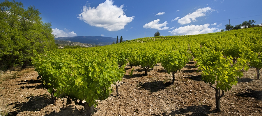
Bezwinge die Berge der Koumandaria – Ursprung einiger der besten zypriotischen Weine – und des dahinter liegendes schröffen Hochlandes auf dieser fordernden Tour. Es geht hoch hinauf bis nach Potamitissa im Herzen der lnsel, wo altehrwürdige Dörfer, byzantinische Klöster und Kirchen (einige von ihnen zählen sogar zum UNESCD-Weltkulturerbe) den Besucher willkommen heißen. Herrlich weite Ausblicke, Serpentinen und steile Abfahrten machen diese Runde zur einem unvergesslichen Abenteuer für erfahrene Fahrer.
Bitte klicken sie hier zum download die beschreibung der route.
Bitte klicken sie hier zum download die route im gpx-format.
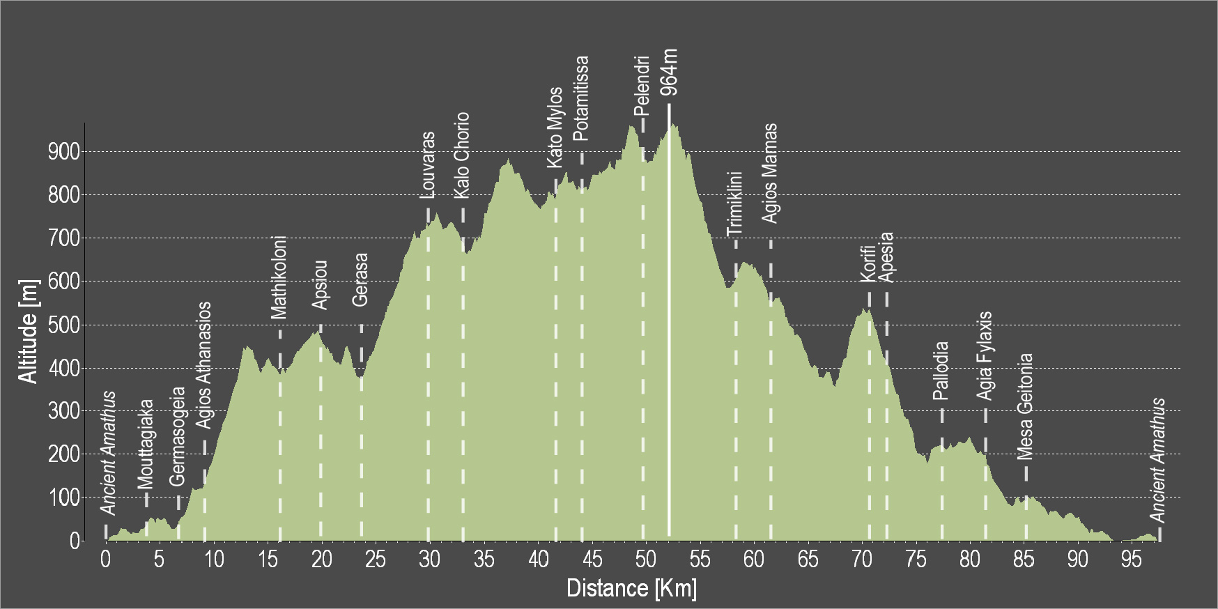
| Distance: | 97.2km |
| Elevation Gain: | 2112m |
| Highest point: | 964m |
| Lowest point: | 1m |
| Loop: | YES |
| Terrain: | Mountain |
| Road surface: | Paved |
| Section Distance (km) | Total Distance (km) | |
| Ancient Amathus | 0,0 | 0,0 |
| Mouttagiaka | 4.0 | 4.0 |
| Germasogia | 2.1 | 6.1 |
| Agios Athanasios | 2.5 | 8.6 |
| Mathikoloni | 8.0 | 16.6 |
| Apsiou | 3.4 | 20.0 |
| Gerasa | 3.4 | 23.4 |
| Louvaras | 6.2 | 29.6 |
| Kalo Chorio | 2.7 | 32.3 |
| Kato Mylos | 8.8 | 41.1 |
| Potamitissa | 3 | 44.1 |
| Pelendri | 5.6 | 49.7 |
| Trimiklini | 8.5 | 58.2 |
| Agios Mamas | 3.6 | 61.8 |
| Korifi | 8.6 | 70.4 |
| Apesia | 1.5 | 71.9 |
| Pallodia | 6 | 77.9 |
| Agia Fylaxis | 3.5 | 81.4 |
| Mesa Geitonia | 3.5 | 84.9 |
| Ancient Amathus | 12.3 | 97.2 |
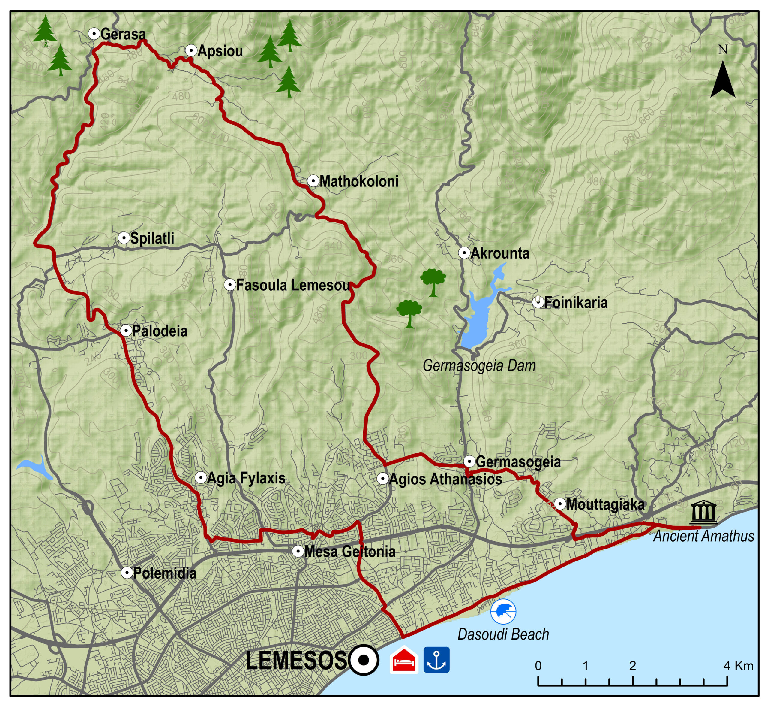
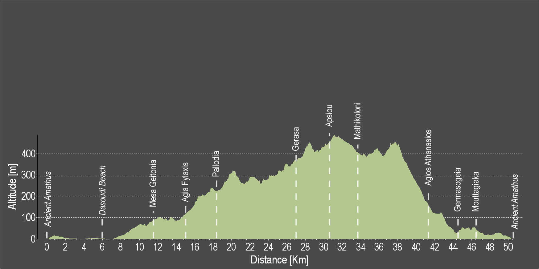
Amathus – Agia Fylaxis – Pallodia – Gerasa – Mathikoloni – Germasogia – Mouttagiaka – Amathus
Eine leichte Tour, die von Amathus durch Randgebiete von Lemesos (Limassol) in die sanfte Berglandschaft Koumandaria, das Herz des zypriotischen Weinanbaus, führt. Nach der Geschäftigkeit der Stadt führt ein schmales Muschelkalktalnach Gerasa. Die Straße wendet sich wieder nach Süden und eröffnet auf dem Rückweg um Mathikoloni atemberaubende Blicke auf Limassol und das Meer.
Bitte klicken sie hier zum download die beschreibung der route.
Bitte klicken sie hier zum download die route im gpx-format.
| Distance: | 50.3km |
| Elevation Gain: | 881m |
| Highest point: | 500m |
| Lowest point: | 1m |
| Loop: | YES |
| Terrain: | Mixed |
| Road surface: | Paved |
| Section Distance (km) | Total Distance (km) | |
| Ancient Amathus | 0,0 | 0,0 |
| Dasoudi Beach | 6.0 | 6.0 |
| Mesa Geitonia | 5.6 | 11.6 |
| Agia Fylaxis | 3.5 | 15.1 |
| Pallodia | 3.5 | 18.6 |
| Gerasa | 8.3 | 26.9 |
| Apsiou | 3.4 | 30.3 |
| Mathikoloni | 3.4 | 33.7 |
| Agios Athanasios | 8.0 | 41.7 |
| Germasogeia | 2.5 | 44.2 |
| Mouttagiaka | 2.1 | 46.3 |
| Ancient Amathus | 4.0 | 50.3 |