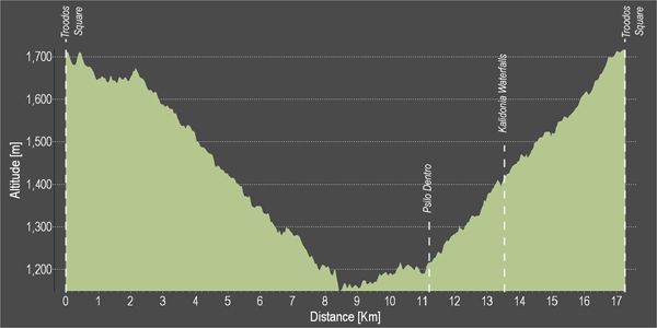
Troodos 1 – Troodos – Agios Nikolaos Stegis – Troodos Cycling Route

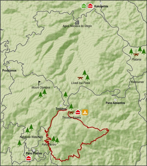
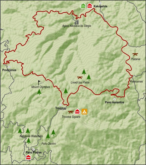
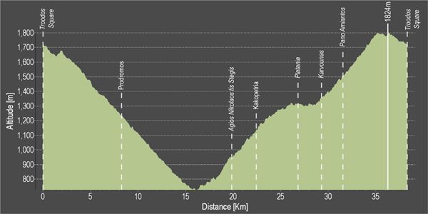
This route descends from Troodos square to the monastery of Agios Nikolaos tis Stegis and climbs steadily from the chromium quarry on the Troodos – Karvounas road, back to Troodos square.

After the Prodromos crossroads, the route goes along a forest road to Agios Nikolaos. From there the it goes along the paved road from Kakopetria to Karvounas, turns right and then climbs Troodos. After almost 9 kilometers of steep uphill the route goes past the Troodos Geopark Information Center in Amiantos. It then reaches the Troodos – Prodromos road and turns left to return to Troodos square.

Difficulty rate: A very difficult route. It requires a 20-speed road bike in good condition.
Road condition: Paved throughout.

To download the route in gpx format click here

Distance: 37.7km
Elevation Gain: 1635m
Highest point: 1824m
Lowest point: 726m
Loop: YES
Terrain: Mountain
Road surface: Paved
Section Distance (km) Total Distance (km)
Troodos Square 0,0 0,0
Prodromos 8,2 8,2
Ag. Nikolaos tis Stegis 11,6 19,8
Kakopetria 2,6 22,4
Platania 4,5 26,9
Karvounas 2,3 29,2
Pano Amiantos 2,3 31,5
Troodos Square 6,2 37,7

Ammochostos 1 – Agia Napa – Pyrgos Xylofagou Cycling Route

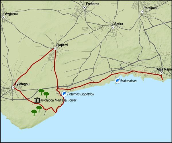
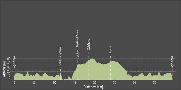
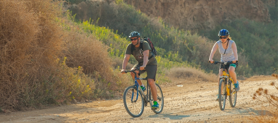
This excursion does the round from Agia Napa to Xylofagou and comes back along the Xylofagou – Agia Napa road.
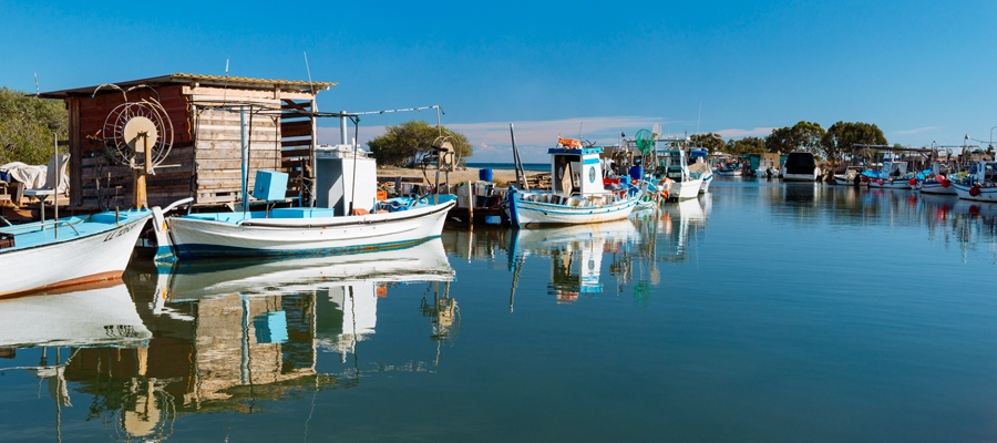
The route begins at the little harbour of Agia Napa and climbs towards the north until it reaches the traffic lights where it turns left and to the west, going along the bicycle path on the left hand side of the road. It then goes past Makronisos on the dirt road that leads to the Agia Thekla chapel and the fishing shelter by the Potamos Liopetriou.
Heading south it goes round Cape Pyla, until it reaches the Xylofagou Medieval Tower. From there it takes a northern course to reach the outskirts of Xylofagou and turns right and to the east taking the Xylofagou – Agia Napa road back to Agia Napa.

Difficulty rate: An easy route but it requires a 21-speed mountain bike.
Road condition: A combination of paved and unpaved roads.

To download the route in gpx format click here
Distance: 38.1Km
Elevation Gain: 78m
Highest point: 51m
Lowest point: 1m
Loop: YES
Terrain: Flat
Road surface: Mixed
Section Distance (km) Total Distance (km)
Agia Napa 0,0 0,0
Potamos Liopetriou 11,4 11,4
Xylofagou Medieval Tower 4,4 15,8
Xylofagou 2,8 18,6
Liopetri 5,4 24,0
Agia Napa 14,1 38,1

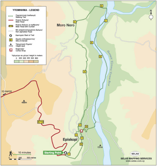
Ezousa Walking Trail (Circular), Pafos (Paphos) District

GPS coordinates of the starting point: Lat: 34.791653 Lon: 32.523179
GPS coordinates of the ending point: Lat: 34.791653 Lon: 32.523179
Altitude of the starting point: 247m
Altitude of the highest peak: 247m
Altitude of the end peak: 247m
Starting point: Environmental Information Centre of Episkopi Pafos.
Length: 7.6km
Estimated duration: 3 hours
Difficulty rate: 2 (downhill and uphill gradient around Ezousa Valley)


Points of interest: The Environmental Information Centre houses exhibition areas with scenes and exhibits, as well as showing documentaries about the natural environment and biodiversity of the surrounding area.

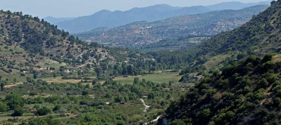
There are excellent views along the way but the most impressive view is from the “Rock” on which the village church, devoted Saint Ilarion the Great, is built. Here, you can enjoy uninterrupted views of the Ezousa Valley below as well as taking in the beauty of nature itself. From this particular point, visibility extends to the Pafos forest and the mountain range of Troodos. The trail crosses over the Ezousa Valley at a certain point with lush growth, especially Oriental Plane Tree and Oriental Alder which offer shade to travelers on hot summer days, making the walk a unique and pleasant experience.

Flora: While walking you can study these indigenous plants: Cyprus cyclamen (Cyclamen cyprium), Bosea (Bosea cypria), Oleander (Nerium oleander), Oriental alder (Alnus orientalis), Oriental plane tree (Platanus orientalis), Oak tree (Quercus infectoria), Locust tree (Ceratonia siliqua), Terebinths (Pistacia Terebinthus), Kermes oak (Quercus coccifera), Spiny broom (Calicotome villosa).

Das Kirchenmuseum in Sotira dorf

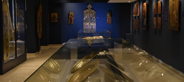
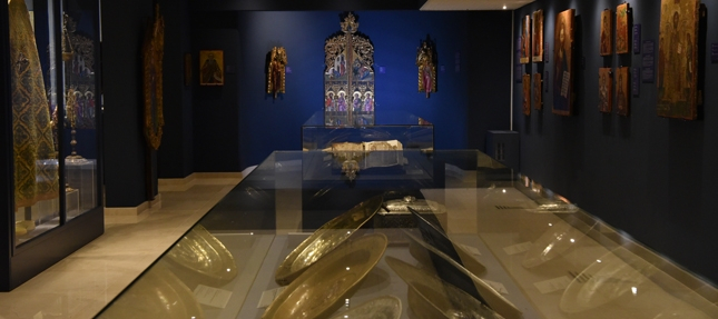
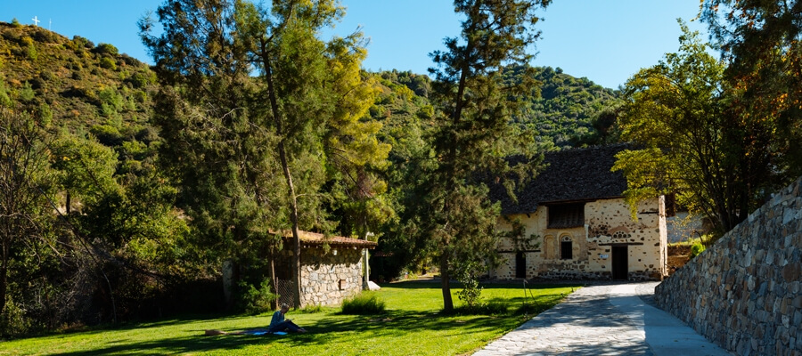
In der Kapelle des Heiligen Georg im Dorf Sotira befindet sich das Ecclesiastical Museum, in dem wichtige religiöse Schätze wie z. B. heilige Ikonen (darunter eine Christus-Ikone aus dem 15. Jahrhundert), alte Versionen des Evangeliums, liturgische Bücher, Kreuze, liturgische Gefäße und andere Artefakte ausgestellt werden. Das Museum beherbergt auch einen tragbaren Holzaltar aus dem 16. Jahrhundert – einer von nur dreien dieser Art auf ganz Zypern.

Neben dem Museum befindet sich die Kirche der Verklärung des Erlösers (Metamórfosis tou Sotíros). Die einschiffige, überwölbte und aus Stein gebaute Kirche wurde auf dem Fundament einer früheren byzantinischen Basilika errichtet.

Das Dorf selbst war in der byzantinischen Epoche von großer Bedeutung, was sich in der Anzahl alter Kirchen in und um das Dorf widerspiegelt.

Bezirk: Ammochostos (Famagusta)
Adresse: Sotira dorf
Kontakt: Telefon: +357 23 823 932
Öffnungszeiten: Besuche nur nach Voranmeldung.
Wann: Das ganze Jahr über.
An gesetzlichen Feiertagen geschlossen.
Eintrittspreis: Kostenlos (Spenden werden dankbar entgegen genommen).
Webseite: www.sotira.org.cy
  Die Öffnungs- und Schließzeiten sowie der Eintrittspreis können sich ohne Vorankündigung ändern. Besuchern wird daher empfohlen, sich im Vorfeld zu informieren.


Das Kulturzentrum der Gemeinde Famagusta (Ammochostos)

Das Cultural Centre von der okkupierten Stadt Ammochostos (Famagusta) wurde für regelmäßig stattfindende Vorträge und Informationssitzungen zum bestehenden Zypernkonflikt (die Teilung der Insel nach der türkischen Invasion im Jahr 1974) geschaffen.

Zur Betrachtung der okkupierten Stadt Famagusta (griechisch Ammochostos) stehen Ferngläser zur Verfügung. Besucher können sich außerdem eine kleine Fotoausstellung ansehen.

Bezirk: Ammochostos
Adresse: Evagorou 35, Deryneia
Kontakt: Telefon: +357 23 740 860; Fax: +357 23 740 861
Öffnungszeiten: Sommer Öffnungszeiten (8.5 – 1.11):
Montag Freitag: 07:30 – 17:00 Uhr
Samstag: 07:30-15:00 Uhr

Winter Öffnungszeiten (4.11 – 5.5):
Montag – Samstag: 07:30 – 15:00 Uhr
Während dieser Zeiten ist das Kulturzentrum für die Öffentlichkeit zugänglich. Für organisierte und geführte Touren können Sie +357 23740860 anrufen oder eine E-Mail an [email protected] senden

Wann: Das ganze Jahr über.
An gesetzlichen Feiertagen geschlossen.
Eintrittspreis: Kostenlos
Barrierefreier Zugang: Rollstuhlgerecht.
Webseite: www.famagusta.org.cy
  Die Öffnungs- und Schließzeiten sowie der Eintrittspreis können sich ohne Vorankündigung ändern. Besuchern wird daher empfohlen, sich im Vorfeld zu informieren.


Die archäologische Ausgrabungsstätte des antiken Idalion

In der Nähe des Dorfes Dali befindet sich einer der wichtigsten Orte Zyperns: die archäologische Ausgrabungsstätte des antiken Idalion. Viele der hier gemachten Funde sind heute in einigen der renommiertesten Museen der Welt ausgestellt.

Das antike Stadtkönigreich Idalion wurde von Chalkanor, Held des trojanischen Krieges und Nachkomme von Teukros (dem Errichter von Salamis) gegründet. Der antiken Mythologie zufolge wurde Adonis, der Geliebte der Aphrodite, in der Gegend von Idalion von einem Eber getötet, der von Aphrodites eifersüchtigem Liebhaber Ares (olympischer Gott des Krieges) geschickt worden war.

Das Königreich blühte bis in die Mitte des 5. Jahrhunderts v. Chr., als seine Hauptstadt durch die phönizischen Könige von Kition belagert und eingenommen wurde. Von den zutage geförderten Fundstücken beider Siedlungen und Friedhöfe der Region lassen sich die ältesten, bei Agridi gefundenen Überreste auf das 7. und 5. Jahrhundert v. Chr. zurückdatieren.

Die archäologische Ausgrabungsstätte beherbergt ein Museum und Besucherzentrum mit ausgestellten Fundstücken und ist Teil des Aphrodite-Kulturwegs.

Bezirk: Lefkosia (Nicosia)
Adresse: Dali Dorf
Kontakt: Telefon: +357 22 444 818
Öffnungszeiten: 16. Montag – Freitag: 08:30 – 16:00 Uhr.
Am Wochenende geschlossen.
Wann: Das ganze Jahr über.
An gesetzlichen Feiertagen geschlossen.
Eintrittspreis: €2,50
Geführte Gruppen mit mehr als 10 Personen erhalten einen Nachlass von 20% auf den Eintrittspreis.
Spezielle Eintrittskarten, die für alle Museen und antiken Monumente gelten, sind bei der zyprischen Altertumsverwaltung erhältlich: Tageskarte (1 Tag): €8,50; Drei-Tages-Karte (3 Tage): €17,00; Wochenkarte (7 Tage): €25,00.
Barrierefreier Zugang: Rollstuhlgerecht.
Webseite: http://www.mcw.gov.cy/mcw/da
  Die Öffnungs- und Schließzeiten sowie der Eintrittspreis können sich ohne Vorankündigung ändern. Besuchern wird daher empfohlen, sich im Vorfeld zu informieren.


European Mediterranean Route EuroVelo 8

Discover and enjoy the natural beauty of the island from the pedal of a bike with our suggested itineraries, all created to put you on the ‘right track’ and showcase Cyprus’ stunning landscape.

Cyprus is also part of the cofunded project ‘MedCycleTour’, which is based on the ‘European Mediterranean Route – EuroVelo 8’, one of the 15 long distance cycle routes in the network ‘EuroVelo’ that connects 11 countries. ‘MedCycleTour’ aims to develop cycle tourism in the Mediterranean region by providing transnational tools to attract visitors. The project is cofunded by the Interreg Mediterranean Programme, the project has a budget of over €2,5 million.

The MedCycleRoute project will contribute to the development of the EuroVelo 8 – Mediterranean Route by exchanging good practices; surveying the existing cycle route; developing regional and transnational action plans; preparing and publishing promotional material related to EuroVelo 8; and implementing pilot projects such as signposting, promotional tools (web sites, apps, etc.) and cycle friendly schemes.

Lead by the Andalusian Government – Agency of Public Works, Andalusian Ministry of Development and Housing (Spain) -, the project has 10 other partners from 7 countries, besides the Deputy Ministry of Tourism. The European Cyclists´ Federation (Belgium), Alpes Maritimes (France), Catalonia Region (Spain), Western Greece (Greece), Friuli Venezia Giulia Region (Italy), Province of Mantova (Italy), Regional Development Center of Koper (Slovenia), Croatian National Tourism Board (Croatia) and the Cluster for Eco-Social Innovation and Development (Croatia).

For more information about EuroVelo please visit: www.eurovelo.com

For more information about EuroVelo 8 please visit: www.eurovelo8.com

For more information about MedCycleTour project please visit: https://medcycletour.interreg-med.eu/ or please contact Thalia Christodoulidou at [email protected].

Happy cycling!

Vasilikos-Maroni-Panorama

Amathus – Germasogia – Arakapas – Eptagonia – Kellaki – Sanida – Vasa – Asgata – Monagroulli – Moni – Pyrgos – Amathus

Eine fordernde Runde, die von Kalavasos entlang der Gebirgsstraße nach Kellaki führt und dabei herrliche Blicke auf den Mount Olympus im Nordwesten und das Vasilikos-Tal zur rechten eröffnet. Das Land zwischen Eptagonia und Vavla ist von Lavaböden und satten Wäldern geprägt. Dann ändert sich die Landschaft plötzlich Wieder zu Kalkstein. Nun geht es entlang des beeindruckenden Maroni-Tals ­ einem schon in der späten Bronzezeit (1.650-1.050 v. Chr.) wichtigen Siedlungsraum – über Choirokoitia und Tochni zurück nach Kalavasos.

Bitte klicken sie hier zum download die beschreibung der route.

Bitte klicken sie hier zum download die route im gpx-format.

Distance: 57.6km
Elevation Gain: 1169m
Highest point: 724m
Lowest point: 65m
Loop: YES
Terrain: Mountain
Road surface: Paved


Section Distance (km) Total Distance (km)
Kalavasos 0,0 0,0
Asgada 6.6 6.6
Vasa 5.1 11.7
Sanida 3.6 15.3
Kellaki 4.1 19.4
Eptagonia 4.5 23.9
Akapnou 3.0 26.9
Ora 3.5 30.4
Lageia 6.3 36.7
Vavla 2.4 39.1
Choirokoitia 9.7 48.8
Choirokoitia Neolithic Settlement 0.0 48.8
Tochni 2.8 51.6
Kalavasos 6.0 57.6

Vasilikos-Maroni-Panorama Intensiv

Kalavasos – Asgata – Kellaki – Eptagonia – Ora – Vavla – Kato Drys – ­ Skarinou – Tochni – Kalavasos

Eine fordernde Runde, die von Kalavasos entlang der Gebirgsstraße nach Kellaki führt und dabei herrliche Blicke auf den Mount Olympus im Nordwesten und das Vasilikos-Tal zur rechten eröffnet. Das Land zwischen Eptagonia und Vavla ist von Lavaböden und satten Wäldern geprägt. Dann ändert sich die Landschaft plötzlich Wieder zu Kalkstein. Von hier geht es hinab in das beeindruckende Maroni-Tal und vorbei am Agios Minas Kloster wieder aufwärts ins reizende Dörfchen Kato Drys. Die temporeiche Abfahrt nach Skarinou und die Fahrt durch Tochni sind weitere Highlights auf dem Rückweg nach Kalavasos.

Bitte klicken sie hier zum download die beschreibung der route.

Bitte klicken sie hier zum download die route im gpx-format.

Distance: 67.3km
Elevation Gain: 1484m
Highest point: 724m
Lowest point: 65m
Loop: YES
Terrain: Mountain
Road surface: Paved
Section Distance (km) Total Distance (km)
Kalavasos 0.0 0.0
Asgada 6.6 6.6
Vasa 5.1 11.7
Sanida 3.6 15.3
Kellaki 4.1 19.4
Eptagoneia 4.5 23.9
Akapnou 3.0 26.9
Ora 3.5 30.4
Lageia 6.3 36.7
Vavla 2.4 39.1
Agios Minas Monastery 2.4 41.5
Kato Drys 3.1 44.6
Skarinou 9.0 53.6
Choirokoitia 4.1 57.7
Choirokoitia Neolithic Settlement 0.0 57.7
Tochni 2.7 60.4
Kalavasos 6.9 67.3

Antikes Vasilikos (ausführlich)

Governor’s Beach – Monagroulli – Asgata – Kalavasos – Tochni – ­ Skarinou – Agios Theodoros – Zygi – Governor’s Beach

Von Governor’s Beach führt diese Runde über Asgata hinab in das Vasilikos-Tal, in dem seit Jahrtausenden Menschen siedeln und unzählige archäologische Funde gemacht wurden. Vorbei an den Dörfern Kalavasos, Tochni und Skarinou wendet sich die Tour nach Agios Theodoros und weiter bis zur Küste. Durch das Fischerdorf Zygi geht es an der Küste entlang zurück nach Governor’s Beach.

Bitte klicken sie hier zum download die beschreibung der route.

Bitte klicken sie hier zum download die route im gpx-format.

Distance: 60.2km
Elevation Gain: 806m
Highest point: 336m
Lowest point: 3m
Loop: YES
Terrain: Mixed
Road surface: Paved
Section Distance (km) Total Distance (km)
Governor’s Beach 0.0 0.0
Monagrouli 8.5 8.5
Asgada 5.1 13.6
Kalavasos 6.7 20.3
Tochni 6.1 26.4
Choirokoitia 3.0 29.4
Choirokoitia Neolithic Settlement 0.0 29.4
Skarinou 3.1 32.5
Agios Theodoros 5.3 37.8
Zygi 12.4 50.2
Governor’s Beach 10.0 60.2